
What to know about a tornado risk across Northern California
THIS VERY BUSY WEATHER DAY WITH OPHELIA. VERY BUSY. AND IT’S ONLY GOING TO GET BUSIER. YOU THOUGHT IT WAS ROWDY AND WINDY AND RAINY TODAY. I THINK THE NEXT 48 HOURS ARE GOING TO BE VERY INTERESTING. NOW THAT WE’RE SEEING THE SUN PEEK THROUGH THOSE CLOUDS, THERE’S A POTENTIAL FOR THUNDERSTORMS, NOT JUST LATER TODAY, BUT FOR CHRISTMAS AS WELL. BUT THIS MORNING THOUGH, WALKING OUT TO SOME STRONG WINDS GUSTING IN THE 40S IN SACRAMENTO, WE HAD EVEN STRONGER WINDS GUSTING IN THE 50S AND 60S IN THE FOOTHILLS. SOUTH LAKE TAHOE, YOUR STRONGEST WIND GUSTS AS OF ABOUT AN HOUR AGO, 35MPH. BUT I THINK THE STRONG WINDS ARE HEADED YOUR WAY. YOU’RE NOT OUT OF THE WOODS YET, BUT RIGHT NOW, WINDS ARE QUIET AROUND THE REGION. WE HAVE A BREEZE IN TRUCKEE, YUBA CITY AND IN FAIRFIELD. THAT’S ABOUT IT. AND EVEN LOOKING AT OUR SKIES LOOKING LIKE IT’S BACK TO NORMAL. BUT I’M SEEING THE SUN BREAK THROUGH THOSE CLOUDS. AND THAT IS AN INDICATOR THAT METEOROLOGISTS NEED TO BE ON THE LOOKOUT FOR THUNDERSTORMS LATER THIS AFTERNOON. IN FACT, THE STORM PREDICTION CENTER HAS HIGHLIGHTED ALL THE SACRAMENTO AND SAN JOAQUIN VALLEY FOR A MARGINAL RISK OF THUNDERSTORMS LATER ON TODAY. SO WHAT HAPPENS WHEN WE HAVE THE CLOUDS OVERHEAD RIGHT NOW, RIGHT. THEY CONTINUE TO BACK OFF. WE GET POCKETS OF SUNSHINE EARLY AFTERNOON AND THAT WARMS UP THE MOISTURE ON THE GROUND, ALLOWING THAT MOISTURE TO RISE REALLY QUICKLY, TURNING INTO THUNDERSTORMS LATER ON THIS AFTERNOON AND EVENING, WE GET A LINE OF SHOWERS MOVE THROUGH. THIS IS A COLD FRONT THAT WILL PASS CHRISTMAS MORNING, AND SAME STORY TOMORROW. SUNSHINE RETURNS IN THE MORNING, LATE MORNING, TURNING INTO MORE THUNDERSTORMS FOR YOUR CHRISTMAS AFTERNOON AND EVENING. SO CERTAINLY BE ON THE LOOKOUT FOR THUNDER AND LIGHTNING TOMORROW. IF YOU HAVE ANY OUTDOOR PLANS. WHEN THUNDER ROARS, GO INDOORS AND WE’RE GOING TO KEEP THINGS EVEN MORE INTERESTING WITH THOSE WINDS THAT ARE GOING TO PICK UP BY EVENING. YOU SEE THIS LINE RIGHT HERE, 20 MILE PER HOUR WINDS. THESE ARE SUSTAINED WINDS. WE’RE GOING TO HOLD ON TO THAT THROUGH THE NIGHT WITH WINDS GUSTING 40 TO 50MPH IN THE VALLEY. THAT COULD GET AS HIGH AS 100MPH IN THE SIERRA, IN THE VERY RIDGE TOPS. SO TOMORROW IS AN IMPACT DAY ACROSS THE REGION, ESPECIALLY IN THE SIERRA. NOT ONLY WILL IT BE WINDY FOR THEM, BUT BLIZZARD WITH HEAVY SNOW, THAT SNOW LEVEL NOW DROPPING TO ABOUT 5000FT AND THEN FURTHER DOWN TO 4000FT. ON FRIDAY. SEVEN-DAY FORECAST HERE IN THE VALLEY. IT IS A MESSY HOLIDAY AND YOU HAVE WEATHER IMPACTS ON FRIDAY AS WELL. IF YOU CAN WAIT UNTIL SATURDAY OR SUNDAY TO TRAVEL BY CAR TO WHEREVER YOU NEED TO GO BACK TO, I WOULD ABSOLUTELY DO IT BECAUSE THE WINDS W
What to know about a tornado risk across Northern California

Updated: 10:57 AM PST Dec 24, 2025
Thunderstorm chances increase on Wednesday and Thursday across Northern California. These storms could be strong, and a few funnel clouds or a tornado can’t be ruled out. Christmas EveThe Storm Prediction Center has a portion of the Central Valley under a marginal thunderstorm threat on Wednesday. This means conditions are ripe for a thunderstorm to develop. If a storm hits, it could produce downpours, gusty winds and lightning. Christmas DayThe Storm Prediction Center has much of the coast of Northern California under a marginal risk of thunderstorms on Thursday. An isolated thunderstorm or a brief spin-up can’t be ruled out across the region. Northern California has a 2% chance of a tornado on Thursday. Areas with the best chances for a tornado are San Jose, San Francisco, Oakland and Santa Rosa. Find a full forecast here.REAL-TIME TRAFFIC MAPClick here to see our interactive traffic map.TRACK INTERACTIVE, DOPPLER RADARClick here to see our interactive radar.DOWNLOAD OUR APP FOR THE LATESTHere is where you can download our app.Follow our KCRA weather team on social mediaMeteorologist Tamara Berg on Facebook and X.Meteorologist Dirk Verdoorn on FacebookMeteorologist/Climate Reporter Heather Waldman on Facebook and X.Meteorologist Kelly Curran on X.Meteorologist Ophelia Young on Facebook and X.Watch our forecasts on TV or onlineHere’s where to find our latest video forecast. You can also watch a livestream of our latest newscast here. The banner on our website turns red when we’re live.We’re also streaming on the Very Local app for Roku, Apple TV or Amazon Fire TV.See more coverage of top California stories here | Download our app | Subscribe to our morning newsletter | Find us on YouTube here and subscribe to our channel
SACRAMENTO, Calif. —
Thunderstorm chances increase on Wednesday and Thursday across Northern California. These storms could be strong, and a few funnel clouds or a tornado can’t be ruled out.
Christmas Eve
The Storm Prediction Center has a portion of the Central Valley under a marginal thunderstorm threat on Wednesday. This means conditions are ripe for a thunderstorm to develop. If a storm hits, it could produce downpours, gusty winds and lightning.

KCRA 3
Marginal thunderstorm threat for the central valley, including Sacramento on Wednesday December 24, 2025.
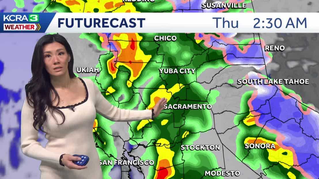
Christmas Day
The Storm Prediction Center has much of the coast of Northern California under a marginal risk of thunderstorms on Thursday. An isolated thunderstorm or a brief spin-up can’t be ruled out across the region. Northern California has a 2% chance of a tornado on Thursday. Areas with the best chances for a tornado are San Jose, San Francisco, Oakland and Santa Rosa.

KCRA 3
Christmas Day thunderstorm risk across Northern California.
REAL-TIME TRAFFIC MAP
Click here to see our interactive traffic map.
TRACK INTERACTIVE, DOPPLER RADAR
Click here to see our interactive radar.
DOWNLOAD OUR APP FOR THE LATEST
Here is where you can download our app.
Follow our KCRA weather team on social media
Meteorologist Tamara Berg on Facebook and X.Meteorologist Dirk Verdoorn on FacebookMeteorologist/Climate Reporter Heather Waldman on Facebook and X.Meteorologist Kelly Curran on X.Meteorologist Ophelia Young on Facebook and X.
Watch our forecasts on TV or online
Here’s where to find our latest video forecast. You can also watch a livestream of our latest newscast here. The banner on our website turns red when we’re live.
We’re also streaming on the Very Local app for Roku, Apple TV or Amazon Fire TV.
See more coverage of top California stories here | Download our app | Subscribe to our morning newsletter | Find us on YouTube here and subscribe to our channel