
TRY TO GET YOURSELF INDOORS AND AWAY FROM THE WINDOWS AND JUST WAIT FOR THIS STORM TO PASS. DON’T TRY TO DRIVE IN ANY STANDING WATER. TRY TO AVOID THAT AT ALL COSTS IF YOU CAN, BECAUSE YOU COULD SEE SOME PRETTY RAPID RISING AREAS OF WATER. NOW WE’RE TALKING MAINLY JUST IN THE STREETS IS WHERE WE’LL SEE THIS IN LOW LYING AREAS. BUT THIS IS GOING TO BE A CONCERN OVER THE NEXT HALF AN HOUR OR SO. WE’LL BE KEEPING YOU UP TO DATE WITH ANY DEVELOPMENTS THAT COME FROM THIS. BUT RIGHT NOW THERE IS A SEVERE THUNDERSTORM WARNING ISSUED BY THE NATIONAL WEATHER SERVICE FOR THE NORTHEAST CORNER OF SACRAMENTO COUNTY, AND IT DOES STRETCH INTO PORTIONS OF PLACER COUNTY AND EL DORADO COUNTY OVER THE FOLSOM LAKE AREA INTO GRANITE BAY AND THEN HEADING UP TOWARDS AUBURN. SO THAT’S THE LATEST. WITH
Severe thunderstorm warning issued in the greater Sacramento area

Updated: 2:48 PM PST Dec 25, 2025
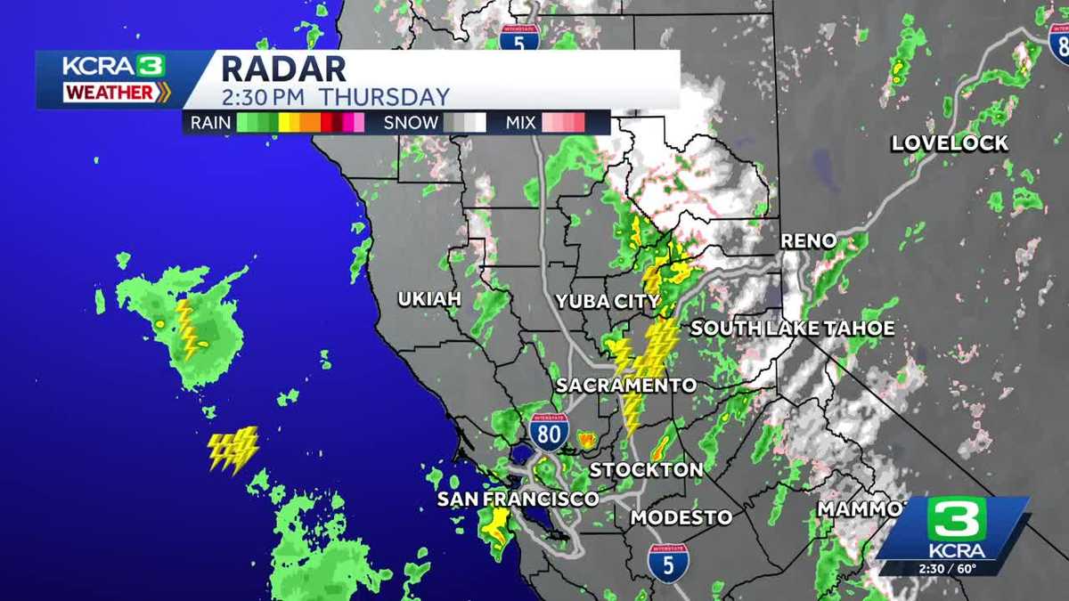
A severe thunderstorm warning was issued Thursday afternoon for parts of Northern California. The warning covered northeastern Sacramento, west-central El Dorado and south-central Placer counties through 3 p.m. Winds of 60 mph and quarter-sized hail are possible, the National Weather Service said.Impacted locations include: Roseville, Citrus Heights, Folsom, Rocklin, Auburn, Fair Oaks, El Dorado Hills, Loomis, Pilot Hill, Newcastle, Granite Bay, Natomas, and Orangevale.People should move to an interior room on the lowest floor of the building.See more coverage of top California stories here | Download our app | Subscribe to our morning newsletter | Find us on YouTube here and subscribe to our channel
SACRAMENTO, Calif. —
A severe thunderstorm warning was issued Thursday afternoon for parts of Northern California.
The warning covered northeastern Sacramento, west-central El Dorado and south-central Placer counties through 3 p.m. Winds of 60 mph and quarter-sized hail are possible, the National Weather Service said.
This content is imported from YouTube.
You may be able to find the same content in another format, or you may be able to find more information, at their web site.
Impacted locations include: Roseville, Citrus Heights, Folsom, Rocklin, Auburn, Fair Oaks, El Dorado Hills, Loomis, Pilot Hill, Newcastle, Granite Bay, Natomas, and Orangevale.
This content is imported from Twitter.
You may be able to find the same content in another format, or you may be able to find more information, at their web site.
People should move to an interior room on the lowest floor of the building.
See more coverage of top California stories here | Download our app | Subscribe to our morning newsletter | Find us on YouTube here and subscribe to our channel