
Time is running out! Your donation to Berkeleyside can be matched—but only until midnight on Dec. 31. Give now and double your support of our nonprofit journalism.
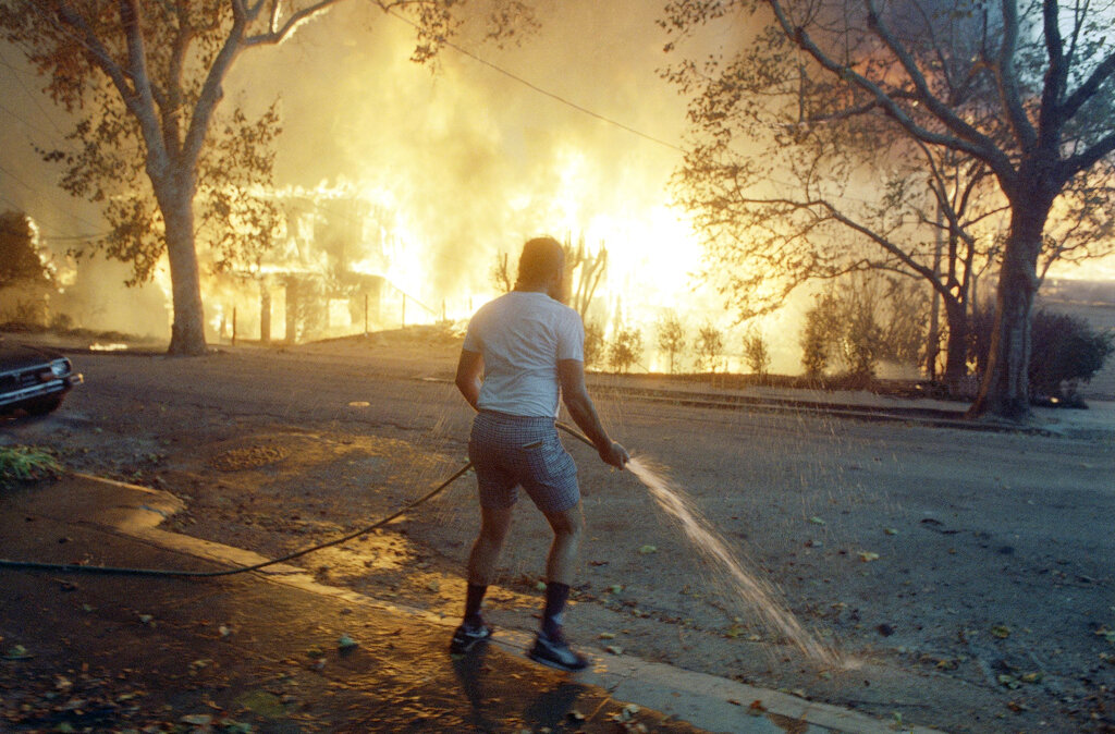
 Berkeley resident Jim Beatty stands hopelessly with a garden hose as homes burn out of control in the Berkeley Hills area on Sunday, Oct. 20, 1991. File photo: AP/Kevin Rice
Editors’ note: This week we’re republishing some of our favorite stories of 2025. This story was first published on July 17.
Some people who live, work and study in Berkeley may not be able to get out of danger zones fast enough the next time a wildfire or tsunami threatens the city, according to a long-awaited new study.
An evacuation of the Berkeley Hills for a wind-driven wildfire could take longer than four hours, by which point a fast-moving fire could easily begin to overtake evacuees stuck in traffic, according to the study.
“The really, really fast winds and really, really low humidity can push a fire so fast that even if you do everything perfectly and you’re set up to get the notifications, and you can leave your house really, really fast, the spread of fire could still outpace evacuation,” Berkeley Emergency Services Manager Sarah Lana told Berkeleyside in an interview Wednesday. “We’ve seen this time and time again, we’ve seen it in L.A., we’ve seen it in Maui, we’ve seen it in Paradise. We saw it here in 1991.”
Berkeley’s emergency officials have built a number of tools for residents to streamline their evacuation plans in connection with the two-year study by New York-based KLD Associates. And the city has renewed its plea for residents in the Berkeley Hills to leave the area preemptively when weather conditions are most conducive to wind-driven wildfires.
Evacuating during a disaster
The study found that evacuating the Berkeley waterfront for a tsunami could take over 2 hours.
The city is asking that Berkeleyans consider evacuating on foot or by bicycle rather than by car during a tsunami.
In a wildfire, the city says leaving the hills in a vehicle is usually safest.
Some other details of what the consultants determined:
People might take as long as three and a half hours to get on the road to evacuate.
Evacuees may need to use smaller and side roads in addition to main ones during a major event.
More than one in five households have school-age children within the city; of those, nearly all of them plan to pick up children themselves “or send a trusted guardian,” all of which is likelier to increase traffic near schools and wider evacuation areas.
Nearly everyone in Berkeley, 89% of households, plans on evacuating in their own cars — in some households, in several cars. The city recommends considering carpools whenever possible.
Most of Berkeley’s carless residents plan to rideshare with neighbors and friends, but there are still roughly 1,686 residents “who will rely on transportation assistance from the government.”
A tiny fraction of people who live, work and study in Berkeley plan to evacuate on foot (2.2%) or by bicycle (1.4%). The city recommends people consider non-vehicle evacuation plans for tsunami alerts.
Roughly 1% of people will simply ignore evacuation orders and stay in place, even in an emergency evacuation.
Traffic calming measures make roads safer day to day, but could slow down evacuation traffic.
Evacuating in phases for a wildfire, starting with those closest to the fireline, “results in similar or worse evacuation times.”
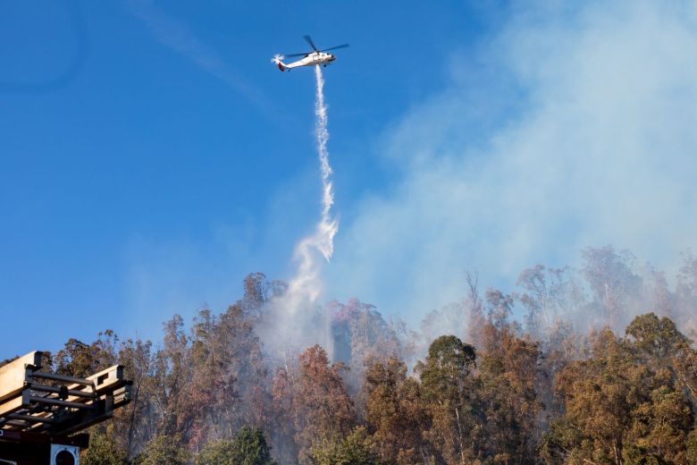 A firefighting helicopter performs a water drop over the Keller fire in Oakland on Friday, Oct. 18, 2024. Credit: Estefany Gonzalez
The city first hired the consultants in March 2023 for $400,000. That figure increased to $600,000 the next year when the city asked for additional reports to comply with state requirements and an analysis on how increasing housing density in the Berkeley Hills could affect neighborhoods at highest risk from wildfires.
Evacuating Berkeley disaster zones takes hours
Projected evacuation times, during the busiest times the week, were:
Up to or more than 4 hours in a repeat of the 1923 fire that left thousands homeless
Up to 1 hour 45 minutes for a fire on Panoramic Hill.
Up to 1 hour 45 minutes for a “phase 3 tsunami warning,” or a tsunami mostly putting the Berkeley Marina and outermost bayshore at risk.
Up to 2 hours 15 minutes for a “max phase tsunami warning,” where everything as far east as Seventh Street is at risk.
The estimates include both the time needed for people to actually leave their homes and how long it would take to get to safety. (They are worst-case estimates. The process can move a lot faster overnight and on weekends, and during the summer when children are not in school, according to the study.)
Those tsunami evacuation times may be enough to get to safety if one is set off near the Aleutian Islands or another faraway fault line. But a subduction earthquake on a nearby fault line could drive a tsunami onshore in Berkeley in less time than it would take to evacuate. (A strike-slip earthquake prompted an evacuation in December, but the alert was later canceled. It is not usually immediately apparent what sort of quake has occurred.)
“Although near-source tsunamis on local faults with only minutes of notice are possible, scientists consider this unlikely,” according to a memo to the City Council from City Manager Paul Buddenhagen.
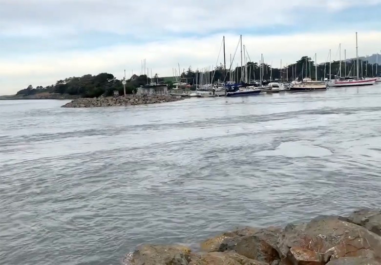 On Jan. 15, 2022, seawater from a tsunami surged into the Berkeley Marina following an underwater volcano eruption in Tonga. Credit: Jacqueline Bott, California Geological Survey
A worst-case tsunami could flood parts of the city’s waterfront up to an 18-foot elevation. Because of how narrow the tsunami evacuation zone is, walking or biking eastward could be quicker than trying to drive, according to a city guide to the study results.
Conversely, in the case of a wildfire in the Berkeley Hills, emergency officials do not recommend walking or biking, as “pedestrians and cyclists in the hills are especially exposed — not just to heat, smoke and dangerous gases, but also to traffic collisions.” The consultants acknowledged that leaving by foot or bike may seem faster, but that their study stopped short of analyzing whether that was true.
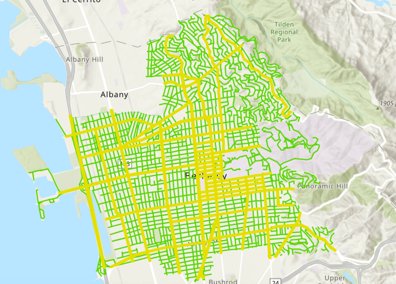 Berkeley’s highest-capacity roadways for evacuation are shown in yellow. Credit: City of Berkeley
The consultants projected evacuations under a number of hypothetical disasters, such as if a fire came into Berkeley from the northeast as it did in the 1923 fire that left thousands homeless, or if a fire were to threaten the Panoramic Hill neighborhood, which poses particular challenges due to its narrow, winding roads and single egress route.
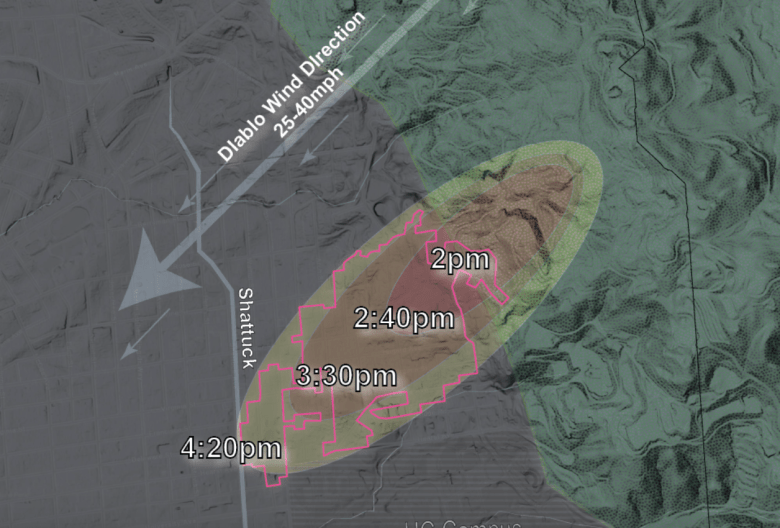 Visualizing the speed the 1923 fire spread downhill in Berkeley. Credit: City of Berkeley
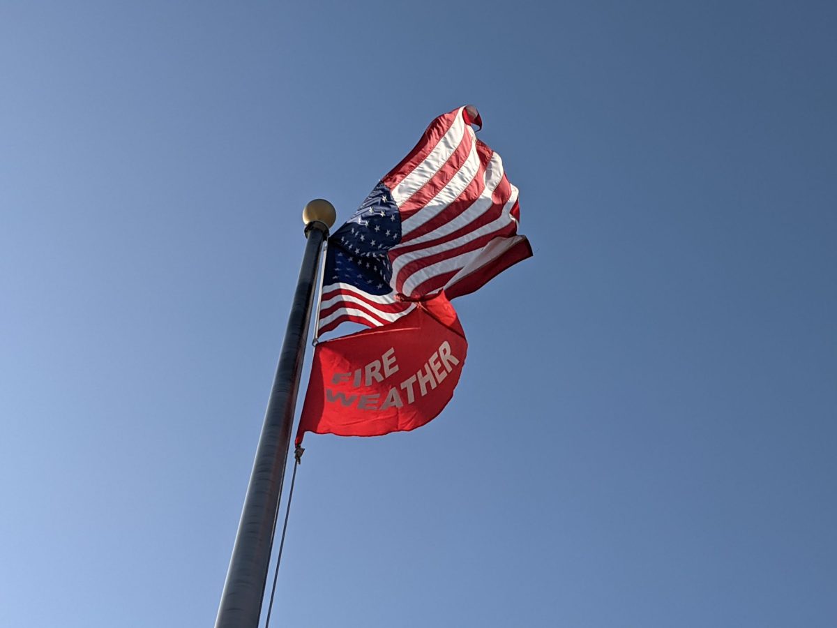
Extreme fire weather
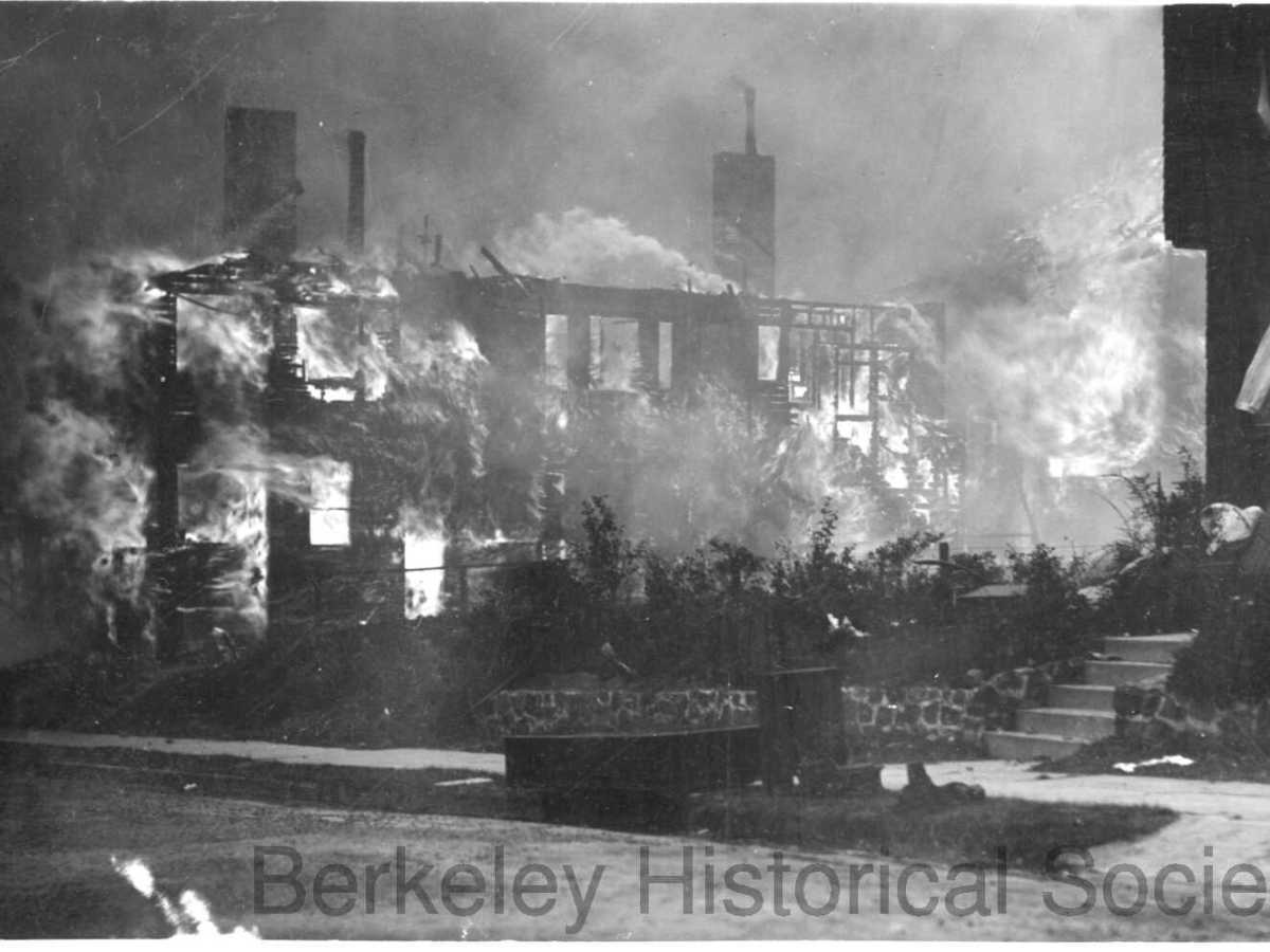
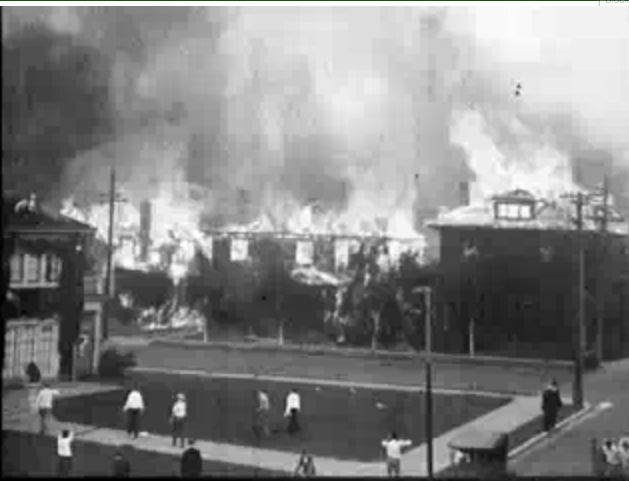 The 1923 fire in Berkeley. Credit: Prelinger Archives/Wikimedia
Given how long it could take the Berkeley Hills to evacuate for a fire, Berkeleyans could very easily be overtaken by a fire they are trying to flee.
For that reason, among others, Berkeley’s emergency officials have pleaded that hills residents take a cautious, proactive approach, and evacuate preemptively when humidity and wind conditions are ripe for a firestorm, conditions the city refers to as “extreme fire weather.”
“Berkeley officials expect — and the evacuation study has validated — that in extreme fire weather, flames could outpace evacuation efforts,” according to the announcement. “Evacuees may be caught in fire before they can escape.”
Extreme fire weather is a rare phenomenon. The city asked that hills residents proactively evacuate in October, after the National Weather Service forecast strong offshore winds and high temperatures. Before that, the last time BFD asked for people to preemptively evacuate was in 2020.
“Under current development levels, we know that in a wind-driven fire, people may be stuck on the roads as they try to evacuate,” Lana said. “That’s why we’re pushing really hard on leaving early during extreme fire weather.”
Cutting down on the time it takes to actually get on the road to evacuate is critical, officials say. For that reason emergency workers have asked Berkeleyans to download the Genasys Protect app, which gets realtime evacuation information from Berkeley first responders, and to sign up for AC Alert, which can provide more detailed information.
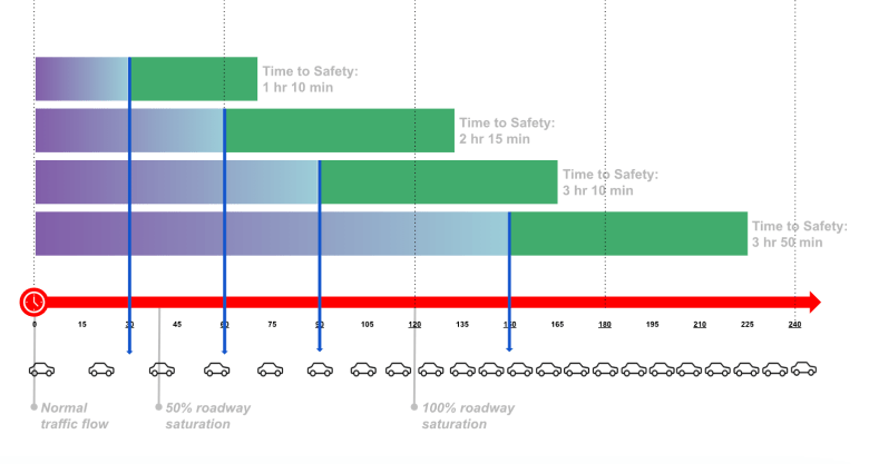 Household evacuation times during a repeat of the 1923 fire. The chart’s purple bars show the amount of time before leaving the house. If you take longer to get ready, your total evacuation time rapidly increases. Times could differ based on how many additional areas must evacuate and what time of day the fire occurs. Credit: City of Berkeley
Not everyone gets alerts as soon as the alerts go out, and different households have different steps — gathering pets, picking up children, packing medications — before they can actually get on the road. The longer you take to leave, “your time on the roadway increases exponentially, and the reason for that is just that, over time, more and more people get on the road, and the slower the traffic goes,” Lana said.
“If you have kids in school, identify someone who can pick them up while you do your evacuation from home,” Lana said, and “make sure that you have a plan that you can enact even if people are away from the household.”
The study also took a look at the possibility of parking restrictions in the hills. Fewer parked cars means more space in driving lanes, so motorists could theoretically drive faster, but once traffic volume increases, the intersections in the hills will become choke points anyway, according to the study.
But some restrictions, if enacted in the right places, could leave room for fire engines, ambulances and other emergency vehicles to get by. Those vehicles would hit traffic at intersections too but, as they would be moving against the prevailing direction, they would not be mired in gridlocked traffic like people trying to get out.
The city has scheduled a series of emergency planning workshops beginning in August. Registration is required and information is available on the city’s website.
Read the full report:
Related stories
Many Berkeley residents are not prepared for a tsunami, survey shows
February 27, 2025Feb. 27, 2025, 2:36 p.m.
100 years after Berkeley’s 1923 fire, another tragedy could be even likelier
September 16, 2023Oct. 4, 2023, 11:10 a.m.
Red Flag and Extreme Fire Weather warnings: What they are and why they matter
September 1, 2021Aug. 4, 2022, 10:52 a.m.

Let’s be real …
These are uncertain times. Democracy is under threat in myriad ways, including the right of a free press to report the truth without fear of repercussions.
One thing is certain, however: Berkeleyside was built for moments like these. We believe wholeheartedly that an informed community is a strong community, so we’re doubling down on our mission of reporting the stories that empower and connect you when it matters most.
If you value the news you read in this article, please help us keep it going strong in 2026.
We’ve set a goal to raise $180,000 by year-end and we’re counting on our readers to help us get there. And a bonus: Any gift you make will be matched through Dec. 31 — so $50 becomes $100, $200 becomes $400. Will you make a donation now in support of nonprofit journalism for Berkeley?

Tracey Taylor
Co-founder, Berkeleyside
“*” indicates required fields