
Northern California forecast: Cool and quiet start to the week
We will hold onto similar weather—areas of patchy morning fog will clear for sunny afternoon skies.
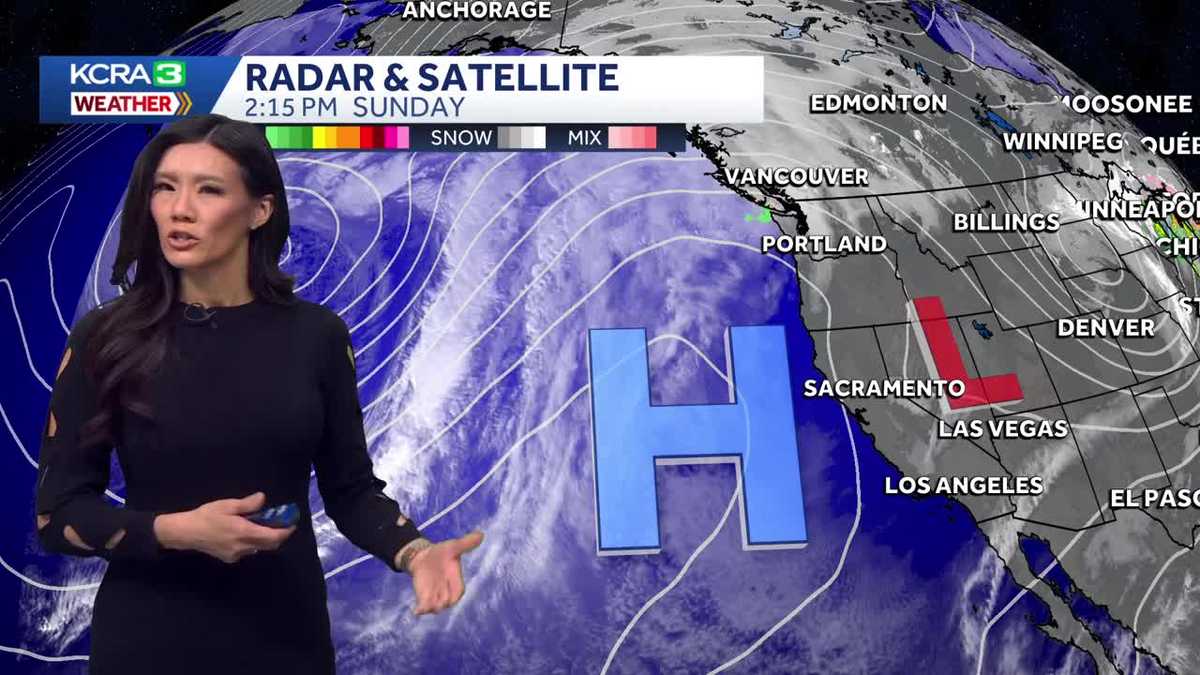
WE’RE HOPING A NEW YEAR, A NEW FORECAST. OPHELIA. NOT SO MUCH RAIN. I’M SORRY TO BE THE BEARER OF BAD NEWS, BUT YEAH, IT’S LOOKING MORE AND MORE LIKE THE SEQUENCE THAT WE SAW ON CHRISTMAS. SO CHRISTMAS WAS WET. LOOKS LIKE NEW YEAR’S EVE IS GOING TO BE WET. WE’RE GOING TO BE RINGING IN THE NEW YEAR WITH SOME BREEZES AND SOME RAINY WEATHER. AS FOR RIGHT NOW, ENJOY THE DRY STRETCH. EVEN THOUGH IT WAS A LITTLE COOLER THAN THE NORMAL. WE GOT UP TO 51 DEGREES TODAY. THE NORMAL FOR DECEMBER 28TH WITH WAS 55 AND OUR 34 DEGREES. THAT WAS COOLER THAN WHAT WE WOULD EXPECT ON A NORMAL DECEMBER 28TH. THAT’S 38 DEGREES RIGHT NOW. TEMPERATURES ARE STILL RELATIVELY COMFORTABLE. WE’RE STILL IN THE 40S AND SACRAMENTO DOWN TO MODESTO. AUBURN DROPPING IN THE 30S NOW, AND TRUCKEE AND SOUTH LAKE TAHOE. YOU’RE IN THE 20S. WE DO HAVE A WIND COMING OUT OF THE NORTH. IT’S NOT VERY STRONG, BUT IT WAS ENOUGH TO HELP KEEP THE FOG AT BAY. THE FOG WILL RETURN TOMORROW MORNING, HOWEVER, BUT NOT UNTIL AFTER WE’VE HAD CLEAR SKIES ALL OF THE NIGHT BEFORE. THAT DOES ALLOW HEAT TO ESCAPE. TEMPERATURES ARE GOING TO DIP INTO THE 30S AND STAY THERE THROUGH THE MORNING HOURS. WE’RE LOOKING AT LOWS NEAR 36 DEGREES TOMORROW. SOME OF THE COLDEST TEMPERATURES THAT WE’VE HAD OVERNIGHT SINCE MARCH. SO WE ARE UNDER A FROST ADVISORY IN THE VALLEY. THIS STRETCHES ALL THE WAY INTO THE FOOTHILLS FOR VERY COLD TEMPERATURES OVERNIGHT. THIS FROST ADVISORY IN EFFECT UNTIL NINE IN THE MORNING. WE’RE GOING TO STAY ABOVE FREEZING. MOST SPOTS OF THE VALLEY, BUT YOUR SENSITIVE PLANTS, THEY MIGHT BE AFFECTED. SO IF YOU CAN BRING THEM INDOORS, I WOULD. HIGH PRESSURE. THAT’S RESPONSIBLE FOR THE CLEAR SKIES. AND THAT’S WHAT ALLOWS ALL OF OUR HEAT TO ESCAPE. RIGHT. WELL, IT’S GOING TO MOVE OVER US TOMORROW. EXPECT SIMILAR WEATHER FOR YOUR MONDAY TUESDAY. HOWEVER, WE’RE GOING TO NOTICE SOME CLOUDS ROLLING UP FROM THE SOUTH THAT IS AHEAD OF A DISTURBANCE THAT WILL BE MOVING IN ON NEW YEAR’S EVE. AND THIS IS WHAT MIDNIGHT LOOKS LIKE. THERE’S A GOOD CHANCE THAT IT WILL BE RAINY AS WE TRANSITION FROM 25 TO 26, AND THE START OF THE YEAR WILL CONTINUE TO BE RAINY AS A COLD FRONT MOVES IN RIGHT BEHIND THAT. IF YOU REMEMBER THE SEQUENCE OF THE STORMS ON CHRISTMAS DAY, THIS IS VERY SIMILAR. SO WE’VE GOT A WET START TO 2026. IT IS A PACIFIC STORM SYSTEM AND THEN A FRONT BACK TO BACK. IT WILL IMPACT US ALL THE WAY THROUGH NEXT WEEKEND. EXPECT WIDESPREAD SHOWERS, BREEZY WIND AND SIERRA SNOW STARTING NEW YEAR’S EVE IN THE FOOTHILLS. NICE COUPLE OF DAYS AND THEN IT GETS MESSY WITH STORMS RETURNING AS EARLY AS LATE WEDNESDAY EVENING. SAME IN THE SIERRA. COULD BE A WET START, BUT I THINK SNOW LEVELS AREN’T GOING TO DROP UNTIL NEXT WEEKEND. HOWEVER, IT WILL BE MAINLY RAIN ALL THE WAY THROUGH AT LEAST THURSDAY. HERE IN THE VALLEY. WE’VE GOT FOG IN THE MORNINGS. NICE AFTERNOON SUNSHINE AND AFTERNOON AFTERNOON SUN WILL TURN INTO SOME FOG ON TUESDAY, OR RATHER SOME CLOUDS ON TUESDAY. AND THEN ON WEDNESDAY WE CAN EXPECT THOSE SHOWERS TO MOVE IN.
Northern California forecast: Cool and quiet start to the week
We will hold onto similar weather—areas of patchy morning fog will clear for sunny afternoon skies.

Updated: 7:54 PM PST Dec 28, 2025
We will hold onto similar weather—areas of patchy morning fog will clear for sunny afternoon skies.After a chilly morning, valley highs will be near 53 degrees. In the foothills, temperatures will also peak in the low 50s, with Sierra highs near 40 degrees.As high pressure continues to move overhead, weather remains quiet all day Monday.On Tuesday, we’ll notice clouds moving up from the south as high pressure shifts east and a low moves up from Southern California.The clouds will be followed by rain on Wednesday. Forecast models now agree that rain will arrive in the evening, and New Year’s Eve will likely be wet. In fact, this storm will jumpstart our next stretch of stormy weather. Winds will pick up behind the New Year’s Eve showers as a cold front moves in. This second system will likely bring higher rain totals and good snowfall for the Sierra.Snow levels will start off high, so precipitation will begin as rain for much of the Sierra. Snow levels will fall to pass level on Friday, with snow forecast for much of the Sierra through next weekend.
SACRAMENTO, Calif. —
We will hold onto similar weather—areas of patchy morning fog will clear for sunny afternoon skies.
After a chilly morning, valley highs will be near 53 degrees. In the foothills, temperatures will also peak in the low 50s, with Sierra highs near 40 degrees.
As high pressure continues to move overhead, weather remains quiet all day Monday.
On Tuesday, we’ll notice clouds moving up from the south as high pressure shifts east and a low moves up from Southern California.
The clouds will be followed by rain on Wednesday. Forecast models now agree that rain will arrive in the evening, and New Year’s Eve will likely be wet. In fact, this storm will jumpstart our next stretch of stormy weather. Winds will pick up behind the New Year’s Eve showers as a cold front moves in. This second system will likely bring higher rain totals and good snowfall for the Sierra.
Snow levels will start off high, so precipitation will begin as rain for much of the Sierra. Snow levels will fall to pass level on Friday, with snow forecast for much of the Sierra through next weekend.