
More fog then rain in the Forecast for Northern California
KCRA 3 Weather meteorologist Dirk Verdoorn looks at when the foggy weather will give way to more rain.
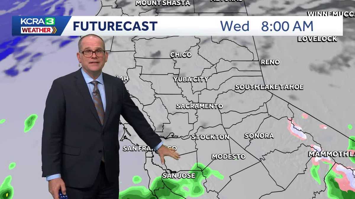
DIRK. PRETTY NICE CALM EVENING OUT THERE. YEAH, YOU KNOW, IT’S ALMOST A TEASE. YOU KNOW, THE SUN SAYS, YEAH, I’M OUT THERE. THE FOG CLEARS AWAY AND WE GET A GLIMPSE OF THE SUNSHINE FROM THE VALLEY. AND THEN TONIGHT WE’RE GOING TO HAVE MORE FOG DEVELOPING AS WE HAVE CLEAR SKIES AND LIGHT WINDS. AS YOU CAN SEE, THE FLAG HERE, THIS IS IN STOCKTON NEAR HAMMER LANE, AND YOU HAVE NO WINDS. IT’S PRETTY CALM RIGHT NOW AND TEMPERATURES ARE GOING TO BE DROPPING. WE MADE IT INTO THE 50S IN STOCKTON, NOW 47 DEGREES STOCKTON SACRAMENTO 4743 IN AUBURN AND 29 DEGREES CURRENTLY AT LAKE TAHOE. HIGH TEMPERATURES TODAY MADE THEIR WAY INTO THE 40S FOR SACRAMENTO 50 IN STOCKTON AND MODESTO 51 YUBA CITY, 54, IN FAIRFIELD, 60 FOR LAKEPORT AND SAN FRANCISCO. 50S. AUBURN AND PLACERVILLE, 30 TRUCKEE AND LAKE TAHOE. SO HIGH PRESSURE IT’S OUT THERE. THAT’S WHY WE DON’T HAVE ANY WIND RIGHT NOW. CLOUD COVER IS AT A MINIMUM, BUT WE’RE GOING TO BE WATCHING SOME CLOUDS THAT WILL BE COMING UP FROM THE SOUTH. SO THERE’S A LITTLE WEATHER SYSTEM THAT’S CURRENTLY OFF THE COAST OF BAJA CALIFORNIA THAT’S GOING TO BE MOVING NORTH. HIGH PRESSURE IS GOING TO MOVE OUT OF THE WAY, ALLOWING THE CLOUD COVER TO MOVE IN. WE’LL START TO NOTICE SOME OF THIS CLOUD COVER AS WE HEAD INTO TUESDAY. AS EARLY AS TUESDAY MORNING. HERE WE ARE 8 A.M. AGAIN. WE WILL HAVE THE FOG ON THE VALLEY FLOOR, AND EVEN IN SOME FOOTHILL LOCATIONS WHERE WE’RE EXPECTING SOME PRETTY DENSE FOG TO BEGIN THE DAY, AND THEN WE’LL JUST HAVE THE HIGH CLOUD COVER MOVING IN, AND THAT MAY HELP TO MIX OUT SOME OF THE FOG. I THINK SOME AREAS MAY BE STUCK IN THE FOG FOR A GOOD PORTION OF THE DAY, THOUGH. ON TUESDAY, KEEPING TEMPERATURES IN THE UPPER 40S TO AROUND 50 DEGREES. BUT WE WILL SEE INCREASING HIGH CLOUDS THROUGH THE AFTERNOON. AND SO IF YOU DO GET SOME SUNSHINE, IT’S NOT GOING TO BE AS CLEAR AS WHAT WE EXPERIENCED TODAY. THICKER CLOUDS WEDNESDAY MORNING AND THEN THE CHANCE FOR SOME RAIN MOVES IN. WE’LL SEE THIS AS EARLY AS 8 A.M. IN THE SOUTH PORTION OF THE BAY NEAR SAN JOSE, AND THEN WORKS ITS WAY WITH A FEW SCATTERED SHOWERS. AND SAN JOAQUIN COUNTY, SACRAMENTO COUNTY, BUT A LITTLE BIT MORE STEADY RAIN A LITTLE AFTER NOON TIME IN MODESTO AND ON INTO TURLOCK, WE’RE LOOKING AT THE RAIN THAT WILL CONTINUE TO COME THROUGH THESE SHOWERS THROUGH WEDNESDAY NIGHT INTO THURSDAY. SO CELEBRATING THE NEW YEAR WITH SOME RAIN IN THE FORECAST. AND THEN THAT WILL START TO EASE UP A LITTLE BIT, BUT NOT GO AWAY AS WE GO THROUGH FRIDAY. IN FACT, IT’S GOING TO PICK UP AGAIN ON FRIDAY. AND THEN SATURDAY WE HAVE SOME COLDER AIR COMING IN AND THERE’S A CHANCE FOR SOME SNOW. BUT RIGHT NOW WE’RE TALKING TEMPERATURES FOR TOMORROW IN THE SIERRA. AFTER A COLD START, TEMPERATURES WILL BE WARMING INTO THE 40S THROUGH THE AFTERNOON, SO IT’S GOING TO BE A LITTLE BIT WARMER THAN IT WAS TODAY. WE’RE LOOKING AT MID TO UPPER 50S IN AUBURN AND PLACERVILLE 60 DEGREES TOMORROW AFTERNOON IN GRASS VALLEY WITH JUST THAT HIGH CLOUD COVER MOVING THROUGH. SO WE’LL HAVE SOME HAZY SUNSHINE THERE. NAPA 56 DEGREES SAN FRANCISCO 58 DEGREES IN FAIRFIELD, WARMING UP TO 52 DEGREES FOR DAYTIME HIGH WITH A LITTLE BIT OF SUNSHINE. I THINK IN THE AFTERNOON AGAIN, CLOUD COVER WILL HAVE THE FOG THROUGH THE MORNING. MAY SEE THAT BREAK UP A LITTLE BIT IN THE AFTERNOON, BUT WE’LL STILL HAVE A LOT OF CLOUD COVER MOVING THROUGH. SO TEMPERATURES IN THE UPPER 40S TO UPPER 40S. I DON’T THINK WE’LL SEE TOO MANY AREAS IN THE LOWER 50S. WE MAY SEE DAVIS AND ROSEVILLE GETTING UP TO AROUND 50 DEGREES VACAVILLE A LITTLE BIT BETTER OF A CHANCE OF 52 SEVEN DAY FORECAST AND CONDITIONS ARE GOING TO BE DRY THROUGH TUESDAY. IT’S THE RAIN MOVES IN ON WEDNESDAY, AND THEN IT PICKS UP ON THURSDAY AND FRIDAY. AND THEN WE HAVE TH
More fog then rain in the Forecast for Northern California
KCRA 3 Weather meteorologist Dirk Verdoorn looks at when the foggy weather will give way to more rain.

Updated: 6:03 PM PST Dec 29, 2025
We are getting a little sun today before the sun goes down and more fog returns. Tuesday looks similar to today without the afternoon sunshine. Clouds increase as well as rain chances Wednesday with rain arriving by late afternoon. Clouds stick around as well as the rain chances for the rest of the week. While the Valley could get between 1-2 inches of rain, it will be spread out over five days with Thursday and Friday looking the wettest right now with over a half inch for Sac. Not much snow is expected until Saturday when cooler air arrives allowing for 6-12″ over the passes for the weekend. Winds are not expected to be an issue during this period.
We are getting a little sun today before the sun goes down and more fog returns. Tuesday looks similar to today without the afternoon sunshine. Clouds increase as well as rain chances Wednesday with rain arriving by late afternoon. Clouds stick around as well as the rain chances for the rest of the week. While the Valley could get between 1-2 inches of rain, it will be spread out over five days with Thursday and Friday looking the wettest right now with over a half inch for Sac. Not much snow is expected until Saturday when cooler air arrives allowing for 6-12″ over the passes for the weekend. Winds are not expected to be an issue during this period.