
Wet weather continues in Northern California to kick off the new year. Plan for wet roads through the morning on Thursday and light to moderate rain across the region. The heaviest rain will be in the morning through about 9 a.m., while the rest of the day will have off and on showers. An isolated thunderstorm can’t be ruled out, and storms may arrive through sunset. Areas south and east of Sacramento are in the best window for an isolated storm. Estimated rain totals are: Valley: 0.50-0.75”Foothills: 0.50-1.00”Sierra: 1.00-2.00”Friday is now looking to be mostly dry with isolated showers, before the next round of rain arrives overnight, Meteorologist Tamara Berg said. The KCRA 3 weather team is issuing Impact Days for both Thursday and then Saturday and Sunday because of how rainy conditions, and eventually snow, could affect travel and outdoor activities.Below are the forecast amounts of Valley rain from Wednesday through Monday: Sacramento: 2-3 inchesStockton: 1-2 inchesModesto: 1-2 inchesYuba City: 3-4 inchesPlacerville: 3-4 inchesSonora: 3-4 inchesSee rain totals so far in the graphic below.WindExpect Valley gusts of 25-30 mph by Saturday. SnowRain is expected in the Sierra through early Friday. By later Friday, snow levels will drop to the 7,000-foot elevation.When enough snow falls on the roads, chain controls could be put into effect. When that happens, vehicles without four-wheel drive or snow tires are required to install chains on their tires.The speed limit on Interstate 80 is also reduced to 30 mph, while it also reduces to 25 mph on Highway 50.Berg said by Saturday afternoon, snow levels will fall to 6,500 feet in the Sierra. On Sunday, snow levels could continue to drop to elevations above 5,000 feet.Snow and wind will make Sierra travel difficult through the weekend, Berg said. From Friday to Sunday, about 8-10 inches of snow could fall at Donner summit and 10-12 inches at Echo Summit. REAL-TIME TRAFFIC MAPClick here to see our interactive traffic map.TRACK INTERACTIVE, DOPPLER RADARClick here to see our interactive radar.DOWNLOAD OUR APP FOR THE LATESTHere is where you can download our app.Follow our KCRA weather team on social mediaMeteorologist Tamara Berg on Facebook and X.Meteorologist Dirk Verdoorn on FacebookMeteorologist/Climate Reporter Heather Waldman on Facebook and X.Meteorologist Kelly Curran on X.Meteorologist Ophelia Young on Facebook and X.Watch our forecasts on TV or onlineHere’s where to find our latest video forecast. You can also watch a livestream of our latest newscast here. The banner on our website turns red when we’re live.We’re also streaming on the Very Local app for Roku, Apple TV or Amazon Fire TV.See more coverage of top California stories here | Download our app | Subscribe to our morning newsletter | Find us on YouTube here and subscribe to our channel
Wet weather continues in Northern California to kick off the new year.
Plan for wet roads through the morning on Thursday and light to moderate rain across the region.
The heaviest rain will be in the morning through about 9 a.m., while the rest of the day will have off and on showers.
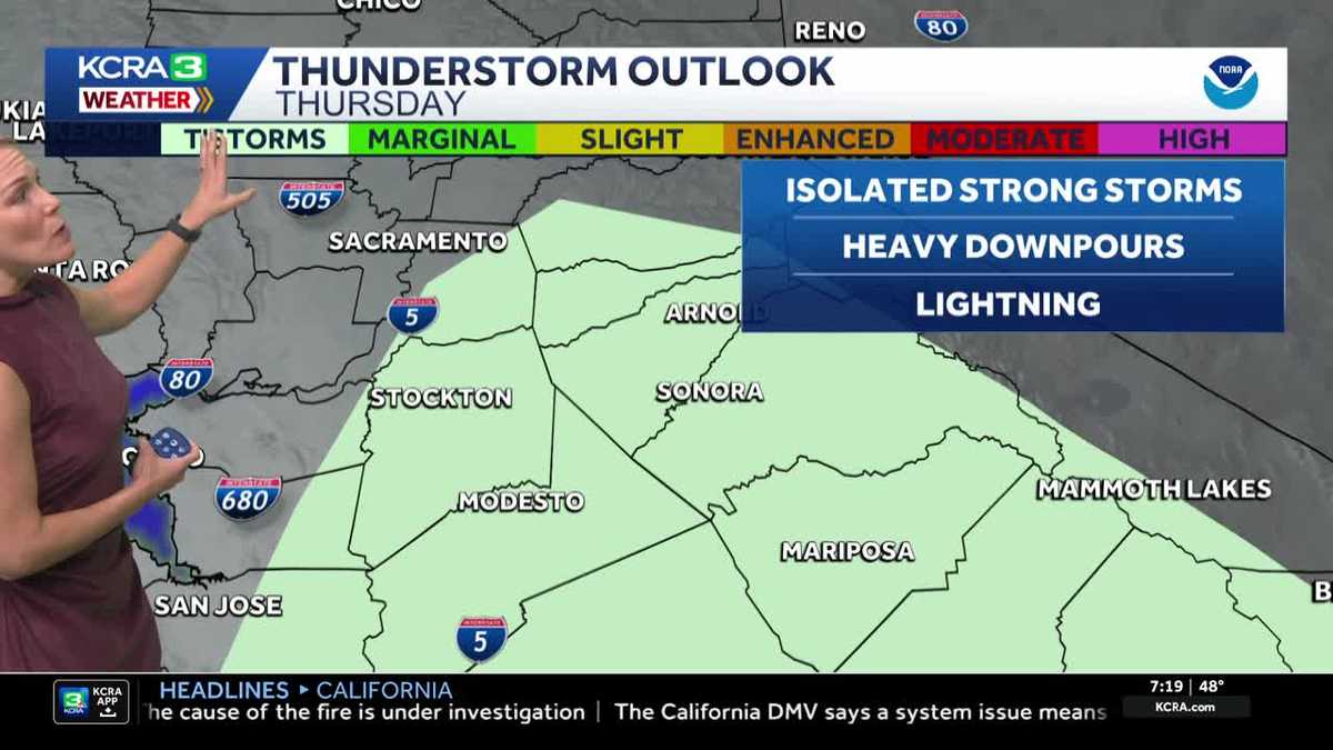
An isolated thunderstorm can’t be ruled out, and storms may arrive through sunset. Areas south and east of Sacramento are in the best window for an isolated storm.
Estimated rain totals are:
Valley: 0.50-0.75”Foothills: 0.50-1.00”Sierra: 1.00-2.00”
Friday is now looking to be mostly dry with isolated showers, before the next round of rain arrives overnight, Meteorologist Tamara Berg said.
The KCRA 3 weather team is issuing Impact Days for both Thursday and then Saturday and Sunday because of how rainy conditions, and eventually snow, could affect travel and outdoor activities.

Below are the forecast amounts of Valley rain from Wednesday through Monday:

Sacramento: 2-3 inchesStockton: 1-2 inchesModesto: 1-2 inchesYuba City: 3-4 inchesPlacerville: 3-4 inchesSonora: 3-4 inches
See rain totals so far in the graphic below.
Wind
Expect Valley gusts of 25-30 mph by Saturday.
Snow
Rain is expected in the Sierra through early Friday. By later Friday, snow levels will drop to the 7,000-foot elevation.

When enough snow falls on the roads, chain controls could be put into effect. When that happens, vehicles without four-wheel drive or snow tires are required to install chains on their tires.
The speed limit on Interstate 80 is also reduced to 30 mph, while it also reduces to 25 mph on Highway 50.
Berg said by Saturday afternoon, snow levels will fall to 6,500 feet in the Sierra. On Sunday, snow levels could continue to drop to elevations above 5,000 feet.
Snow and wind will make Sierra travel difficult through the weekend, Berg said.
From Friday to Sunday, about 8-10 inches of snow could fall at Donner summit and 10-12 inches at Echo Summit.

REAL-TIME TRAFFIC MAP
Click here to see our interactive traffic map.
TRACK INTERACTIVE, DOPPLER RADAR
Click here to see our interactive radar.
DOWNLOAD OUR APP FOR THE LATEST
Here is where you can download our app.
Follow our KCRA weather team on social media
Meteorologist Tamara Berg on Facebook and X.Meteorologist Dirk Verdoorn on FacebookMeteorologist/Climate Reporter Heather Waldman on Facebook and X.Meteorologist Kelly Curran on X.Meteorologist Ophelia Young on Facebook and X.
Watch our forecasts on TV or online
Here’s where to find our latest video forecast. You can also watch a livestream of our latest newscast here. The banner on our website turns red when we’re live.
We’re also streaming on the Very Local app for Roku, Apple TV or Amazon Fire TV.
See more coverage of top California stories here | Download our app | Subscribe to our morning newsletter | Find us on YouTube here and subscribe to our channel