Much of Friday will offer Northern California a break from wet weather, but more rain and snow are expected through the weekend.The KCRA 3 weather team is issuing Impact Days for Saturday and Sunday because of how wet conditions could affect travel and outdoor activities.Meteorologist Tamara Berg said rain is likely to return after sunset hours Friday. South winds could also bring gusts to the region.RainBerg said rain is expected to be on and off for both Saturday and Sunday. Below are the estimated rainfall totals from Friday evening through Monday.Valley: 1-3 inchesFoothills: 3-5 inchesSierra: 4-6 inchesIsolated thunderstorms are possible throughout this period, and Saturday is likely to see stronger storms. If any form, heavy downpours, lightning and funnel clouds could occur.SnowBerg said snow is expected at the Sierra passes level of 7,000 feet by early Saturday. When enough snow falls, road officials are likely to issue chain controls, which means cars without four-wheel drive and snow tires equipped will need chains installed on their tires.The speed limit on Sierra highways is also reduced during chain controls, with Interstate 80 set at 30 mph and Highway 50 at 25 mph.Elevations above 6,000 feet could see two to four feet of snow from Friday evening through Monday. The Carson and Sonora passes may see up to five feet of snow.The National Weather Service issued a Winter Storm Warning from 10 p.m. Friday through 4 p.m. Monday ahead of anticipated near-whiteout conditions and major travel delays. NWS is also discouraging mountain travel during that time.Wind Berg said wind gusts across the Sacramento Valley could range on Saturday from 30-40 mph.See rain totals from previous days in the graphic below.REAL-TIME TRAFFIC MAPClick here to see our interactive traffic map.TRACK INTERACTIVE, DOPPLER RADARClick here to see our interactive radar.DOWNLOAD OUR APP FOR THE LATESTHere is where you can download our app.Follow our KCRA weather team on social mediaMeteorologist Tamara Berg on Facebook and X.Meteorologist Dirk Verdoorn on FacebookMeteorologist/Climate Reporter Heather Waldman on Facebook and X.Meteorologist Kelly Curran on X.Meteorologist Ophelia Young on Facebook and X.Watch our forecasts on TV or onlineHere’s where to find our latest video forecast. You can also watch a livestream of our latest newscast here. The banner on our website turns red when we’re live.We’re also streaming on the Very Local app for Roku, Apple TV or Amazon Fire TV.See more coverage of top California stories here | Download our app | Subscribe to our morning newsletter | Find us on YouTube here and subscribe to our channel
Much of Friday will offer Northern California a break from wet weather, but more rain and snow are expected through the weekend.
The KCRA 3 weather team is issuing Impact Days for Saturday and Sunday because of how wet conditions could affect travel and outdoor activities.
Meteorologist Tamara Berg said rain is likely to return after sunset hours Friday. South winds could also bring gusts to the region.
Rain
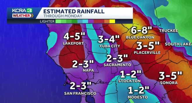
Berg said rain is expected to be on and off for both Saturday and Sunday. Below are the estimated rainfall totals from Friday evening through Monday.
Valley: 1-3 inchesFoothills: 3-5 inchesSierra: 4-6 inches

Isolated thunderstorms are possible throughout this period, and Saturday is likely to see stronger storms. If any form, heavy downpours, lightning and funnel clouds could occur.
Snow
Berg said snow is expected at the Sierra passes level of 7,000 feet by early Saturday.
When enough snow falls, road officials are likely to issue chain controls, which means cars without four-wheel drive and snow tires equipped will need chains installed on their tires.
The speed limit on Sierra highways is also reduced during chain controls, with Interstate 80 set at 30 mph and Highway 50 at 25 mph.
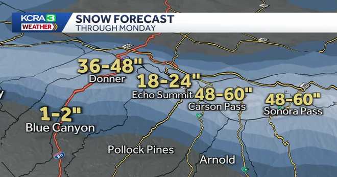
Elevations above 6,000 feet could see two to four feet of snow from Friday evening through Monday. The Carson and Sonora passes may see up to five feet of snow.

The National Weather Service issued a Winter Storm Warning from 10 p.m. Friday through 4 p.m. Monday ahead of anticipated near-whiteout conditions and major travel delays. NWS is also discouraging mountain travel during that time.
Wind
Berg said wind gusts across the Sacramento Valley could range on Saturday from 30-40 mph.
See rain totals from previous days in the graphic below.
REAL-TIME TRAFFIC MAP
Click here to see our interactive traffic map.
TRACK INTERACTIVE, DOPPLER RADAR
Click here to see our interactive radar.
DOWNLOAD OUR APP FOR THE LATEST
Here is where you can download our app.
Follow our KCRA weather team on social media
Meteorologist Tamara Berg on Facebook and X.Meteorologist Dirk Verdoorn on FacebookMeteorologist/Climate Reporter Heather Waldman on Facebook and X.Meteorologist Kelly Curran on X.Meteorologist Ophelia Young on Facebook and X.
Watch our forecasts on TV or online
Here’s where to find our latest video forecast. You can also watch a livestream of our latest newscast here. The banner on our website turns red when we’re live.
We’re also streaming on the Very Local app for Roku, Apple TV or Amazon Fire TV.
See more coverage of top California stories here | Download our app | Subscribe to our morning newsletter | Find us on YouTube here and subscribe to our channel

