
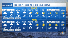
Another weather system will be approaching the region this weekend bringing periods of heavier showers and elevated southerly winds, according to the NWS, which added the wet weather pattern is expected to remain active with chances for showers across the region through Thursday. That will be followed by drier and warmer weather expected the end of next week.
“There is a beach hazard warning for minor coastal flooding in low- lying, flood-prone area for high King Tides expected to peak at 6 to 7 feet through the weekend and ending Monday morning,” said Chandler Price, an NWS forecaster.
Chandler said there will be a wet-weather pattern developing over the weekend that will persist into Monday. “We’re going to have several waves of pretty light showers moving through with one wave expected late tonight or early-morning on Saturday bringing light, off-and-on showers,” he said. “Then there will be a little break after that on Saturday, with an another wave of rain expected to come in Saturday night lingering through Sunday.”

Saturday is expected to be cloudy with a slight chance of showers in the afternoon with highs ranging from 65 to 68 with southerly winds at 10 mph becoming light in the evening. There will be a 50% chance of rain Saturday, the NWS stated.
On Sunday, coastal San Diego is expected to become mostly cloudy during the day with a chance of showers with highs of 64 to 68. Sunday night will be mostly cloudy with a slight chance of thunderstorms, then showers likely overnight with locally heavy rainfall possible overnight. Lows Sunday night along the coast will range from 51 to 55.
On Saturday, valleys will be cloudy with a slight chance of showers in the afternoon with highs of 66 to 69 in the western valleys, and 62 to 67 near the foothills. On Sunday, valleys will be mostly cloudy with a chance of showers and highs of 65 to 68 in the western valleys, and 60 to 65 near the foothills. There will be a slight chance of thunderstorms Sunday night, the NWS stated.
New Year’s Day storm
San Diego got a month’s worth of rain to start the new year.
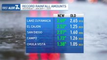
More than two inches of rain fell at San Diego’s airport between midnight and early Thursday afternoon, which surpassed average rainfall totals for the entire month of January at just under two inches, according to NBC 7 Meteorologist Greg Bledsoe.
“It’ll finish as one of the top 15 rainiest days ever in the history of San Diego, dating all the way back to the 1930s,” Bledsoe said.
The large amount of water fell so quickly, many areas up and down San Diego County became flooded, including Mission and Fashion Valleys and Mission Hills.
NBC 7 reporter Joe Little was in Mission Hills on Friday taking a look at the damage from Thursday’s rainstorm. Watch that in the video below:
Businesses were hit with mud and a flood on Thursday, reports NBC 7’s Joe Little.
Mission Valley is an area of San Diego that sees frequent flooding during rain events, and as expected — it got heavily flooded. NBC 7 reporter Brooke Martell was in Mission Valley on Friday assessing the mud, debris and flooded cars that were left on Camino de la Reina. Watch that in the video below:
Those who were in caught in Mission Valley during New Year’s Day’s rainstorm were still reeling from the damage on Friday, NBC 7’s Brooke Martell reports.
The National Weather Service issued a Beach Hazard Statement through Sunday due to the anticipated King Tides from this month’s full super moon. High tides are expected to be around 7 feet, and have the potential to cause minor coastal flooding, the NWS said.