

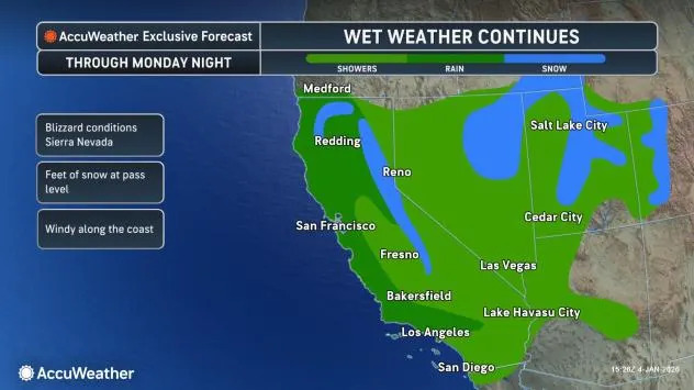
A nearly relentless wet pattern has soaked California and the West for weeks, but relief from the storminess is finally on the horizon. In the meantime, AccuWeather meteorologists are warning Californians and westerners not to put away the rain gear just yet.
“Rainy weather is expected to continue for much of coastal and Northern California through Monday night, as a series of storms continue to hit the state,” said AccuWeather Meteorologist Kai Kerkow.
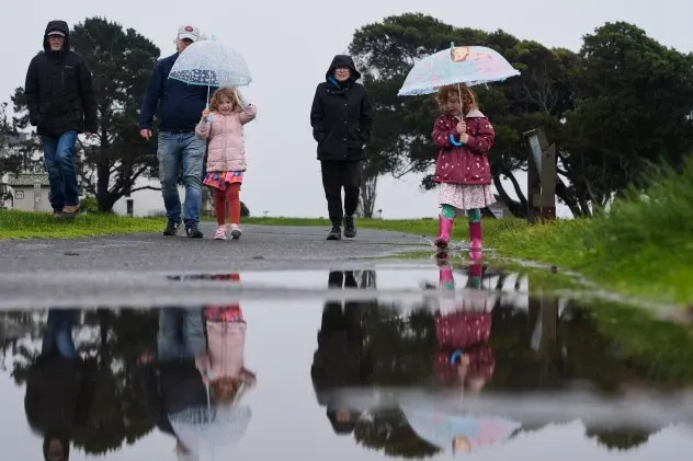
People walk on a trail at Robert W. Crown Memorial State Beach Park in Alameda, Calif., Thursday, Jan. 1, 2026. (AP Photo/Godofredo A. Vásquez)
Beyond Monday, the storm track is expected to shift north, aiming rain and mountain snow more at the Pacific Northwest. Eventually, a large enough area of high pressure will build into the West and help shut off the tap altogether for most through mid-January.
More rain, mountain snow in California early this week
After only a brief break in the days between Christmas and New Year’s, the Golden State has been in a soggy state. AccuWeather forecasters say that the downpours, and snow in the higher elevations, will continue as the first full week of January gets under way.
“Rain can be heavy at times across Central and Northern California through Monday,” said Kerkow. “This will bring the risk for flooding in the mountains as well as urban and poor-drainage areas.”
AccuWeather.com
The wet weather is expected to also impact parts of Southern California into early Monday, with up to another inch of rain possible around Los Angeles beginning late Sunday. The wet weather can slow the morning commute on busy highways such as the 5 and the 101.
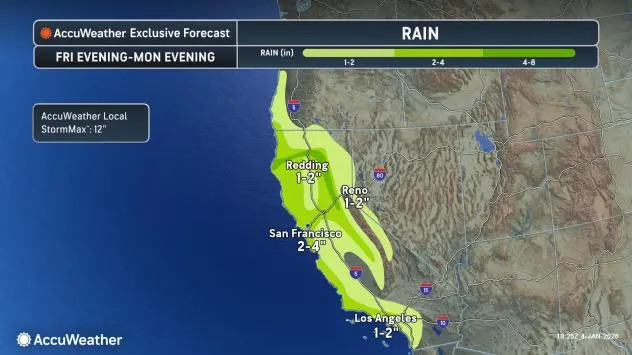
Rainfall totals of over 1 inch will be most common from the central coast into northern parts of the state, where amounts of 2-4 inches or more and localized flooding will be common through Monday night.
AccuWeather.com
To say California has been waterlogged so far this wet season may be an understatement.
Though the period from Oct. 1 to mid-November was rather dry, since Oct. 14, downtown Los Angeles has measured nearly 14 inches of rain, through Jan. 3 (343% of the historical average), while San Diego is at 232% of average. Even areas that typically see more rain over that period, including San Francisco, are also registering above-average totals (128% of average).
Have the app? Unlock AccuWeather Alerts™ with Premium+
In the higher elevations, the snow has proved a boon to the ski resorts, but an inconvenience for travelers. According to Kerkow, the white stuff will continue piling up early in the week. “Multiple feet of fresh powder will fall in the Sierra Nevada mountains through Monday,” he said. “This will cause significant impact to the passes, especially for along Interstate 80 where road closures could be possible.”
The heaviest accumulations will be above 6,000 feet in the Sierra. Donner Pass, which sits an elevation of just above 7,000 feet, was still open as of Sunday morning, local time, but snow chains were required to pass through it.
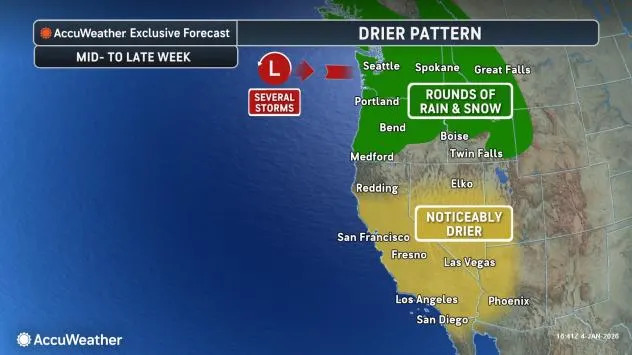
The focus for rain and snow will shift north through midweek
A prolonged break from the precipitation, not seen in California since mid-December, is expected to begin later in the week, according to the AccuWeather forecast.
AccuWeather.com
“From the middle to the end of the week, the storm track will begin to shift north, bringing a drier weather pattern to much of the state and a break in the wet weather,” said Kerkow.
The pattern shift will be driven by a building ridge of high pressure that will be especially felt during the second half of the week. While parts of Northern California may have to contend with some rain and higher-elevation snow on Tuesday and Wednesday, the Bay Area on south will dry out en masse.
That drier weather will not be afforded to the Northwest, as Washington and Oregon inland through northern portions of the Rockies will have to continue to contend with storminess for a few more days.
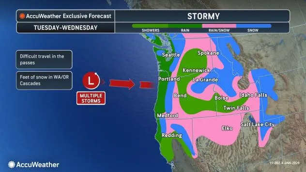
AccuWeather.com
Since the beginning of November, both Seattle and Portland have also been enduring above-average rainfall, with rain gauges reporting measurable precipitation more days than not. There was also historic and deadly flooding in December in parts of western Washington because of multiple atmospheric river events.
While the rain expected this week is not expected to cause widespread flooding, there can be instances of localized ponding and small-stream flooding. In addition, chillier air arriving midweek can also lower snow levels such that flakes could fly in some of the foothills of the Cascades.
By the second full week of January and beyond, the pattern may shift enough that even the majority of the Pacific Northwest can enjoy prolonged dry weather.
Want next-level safety, ad-free? Unlock advanced, hyperlocal severe weather alerts when you subscribe to Premium+ on the AccuWeather app. AccuWeather Alerts™ are prompted by our expert meteorologists who monitor and analyze dangerous weather risks 24/7 to keep you and your family safer.