
Two of the most destructive wildfires on record in California forever changed landscapes and lives when they burned into neighborhoods in the Palisades and Altadena one year ago in a ferocious windstorm.
As the flames from the Eaton and Palisades fires were contained weeks after they ignited Jan. 7, 2025 and large-scale evacuation orders were lifted, property owners returned to see first-hand what was left behind and grapple with the uncertainty what came next.
First came the two-phase cleanup process, which involved the clearing of household hazardous waste by the U.S. Environmental Protection Agency and the removal of structural debris, a task handled by the U.S. Army Corps of Engineers or through a contractor chosen by homeowners. According to the county, more than 10,000 properties opted in to the Corps of Engineers’ debris clearance program.
Once debris was cleared, property owners who sought to rebuild embarked on a permitting process handled by various local governments, including Los Angeles County, the city of Los Angeles, and the cities of Malibu and Pasadena. The city of Los Angeles alone received more than 3,000 permit applications, 1,440 of which have been issued at the start of January, according to the city. Nearly 2,900 applications for rebuilding permits were received by Los Angeles County, 1,153 of which have been issued as of Jan. 2, 2026.
Thousands of applications remain in review.
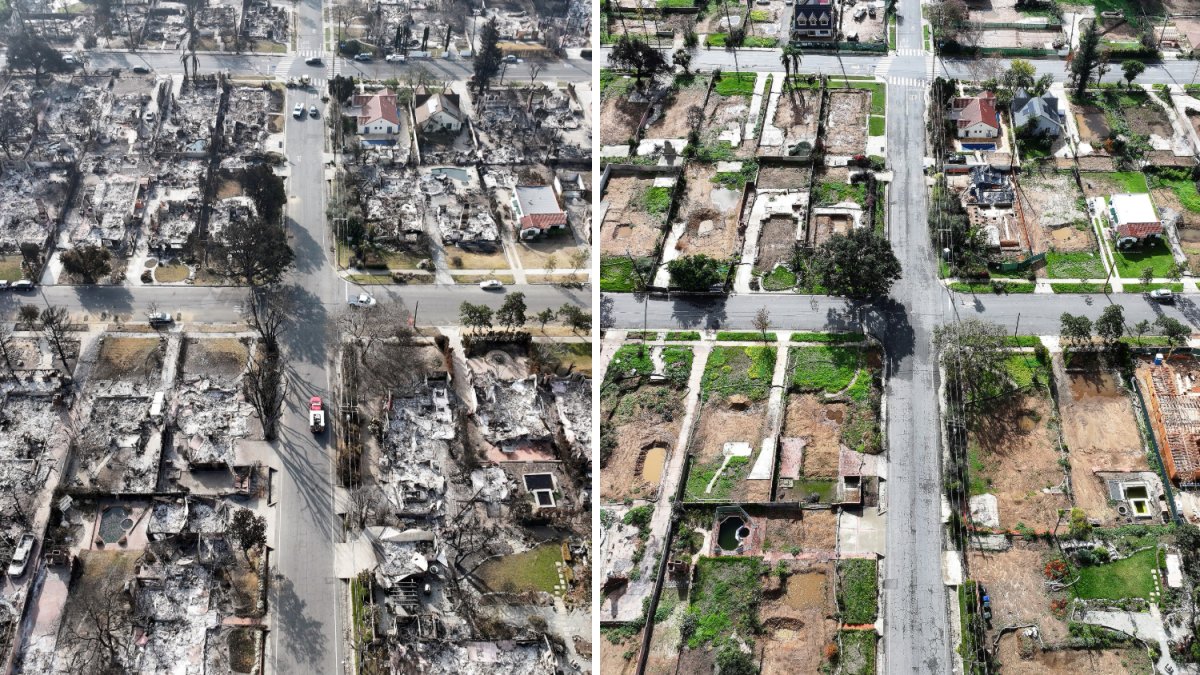
The aerial images below show parts of the Palisades and Altadena after the January Palisades Fire and roughly one year later in later December 2025. Use the slider tool to view images from then and now.
All images below are courtesy of Getty Images.
Altadena and the Palisades, then and now
Use the slider tool at the center of each image to switch views.
In this first aerial image, the rubble of homes that burned in the Eaton Fire and a surviving palm tree are pictured on Jan. 19, 2025 in Altadena. The same area is pictured in December 2025 with a cleared lot and a remaining pool.
In this aerial view, Bishop Charles Dorsey leads a prayer rally April 12, 2025 for the Altadena community and for his church in what remained of the Lifeline Fellowship Christian Center after the Eaton Fire. The same area is pictured in December 2025 with a cleared lot.
Below, an aerial view of homes that burned in the Eaton Fire on Feb. 5, 2025 in Altadena and the same area as rebuilding continues on Dec. 28, 2025.
An aerial view of an Altadena neighborhood that was mostly destroyed in the Eaton Fire on Jan. 19, 2025 and the same area with some homes rebuilt nearly one year later
An aerial view shows homes that burned near two that were not destroyed in the Eaton Fire on Jan. 19, 2025 in Altadena and how the neighborhood looked at the end of December 2025.
Below, an aerial view of homes near the Pacific Ocean that were destroyed in the Palisades Fire with some lots cleared of debris on March 15, 2025 in Pacific Palisades and the same area in December 2025.
Below, a view of destroyed homes veiled in wildfire smoke as the Palisades Fire continued to burn in Los Angeles County on January 10, 2025 and the same area with vibrant green hillsides in December 2025.
An aerial view of homes destroyed in the Palisades Fire on Jan. 27, 2025 in Pacific Palisades and the same area with cleared lots and construction in December 2025.
An aerial view shows homes destroyed in the Palisades Fire on Jan. 27, 2025 in Pacific Palisades and how the area looks nearly one year later.
An aerial view of trees and homes that burned in the Palisades Fire on Jan. 28, 2025 in Pacific Palisades with an aerial view of surviving trees and cleared lots on Dec. 22, 2025.
The 23,700-acre Palisades Fre became the ninth-deadliest and third-most destructive wildfire on record in California. Twelve deaths were reported in connection with the Palisades Fire, which destroyed more than 6,800 structures.
The Eaton Fire grew to 14,000 acres, leaving 19 people dead and destroying 9,400 structures. It is the fifth-deadliest and second-most destructive wildfire in California history.