
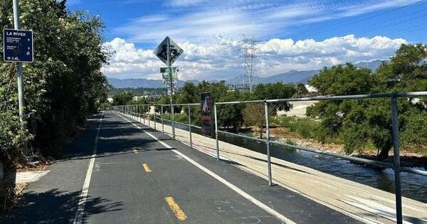

A stretch of the Los Angeles River Bike Path in Elysian Valley, part of the car-free route Metro hopes to extend south through Lincoln Heights, Boyle Heights, Vernon, and Maywood.
Photo by Katrina Alexy
Imagine riding a bicycle along the Los Angeles River all the way from the San Fernando Valley to Long Beach—a distance of more than 30 miles—and never sharing the road with cars.
The only thing preventing that along the Los Angeles River Bicycle Path is an eight-mile stretch of largely industrial areas between Riverside Drive in Elysian Valley and Atlantic Boulevard in Vernon and Maywood.
Success! An email has been sent to with a link to confirm list signup.
Error! There was an error processing your request.
After more than 10 years of study and community feedback, Metro has settled on a proposed plan and possible modifications to bridge that gap. Doing the entire length could cost up to $1.2 billion, while covering just parts of it could run as high as $690 million. Phased construction is scheduled for 2028 to 2031.
How to submit comments to the report.
Eastside Public Hearings
A Metro map showing the proposed LA River Bike Path route and design options between Elysian Valley, Downtown Los Angeles, Vernon, and Maywood.
Image from the EIR Draft by L.A. Metro
Success! An email has been sent to with a link to confirm list signup.
Error! There was an error processing your request.
The proposed project
The path would switch back and forth across the river between the west and east banks four times, with additional crossings at three of the nine new access points, including Lincoln Heights, Boyle Heights, the Arts District, and Vernon.
Alternative modifications
Option 1: More of the trail by Lincoln Heights and Boyle Heights would be on the east bank of the river instead of the west. There would be only six river crossings but 11 new access points, including Lincoln Heights, Chinatown, Little Tokyo, the Arts District, and Vernon.
Option 2: More of the trail for our area would be back on the west bank. It would have seven river crossings with nine new access points, including Lincoln Heights, Boyle Heights, the Arts District, and Vernon.
Mostly East Bank Alternative: With six new access points on the east bank of the river, and three on the west bank.
Mostly West Bank Alternative: With six new access points on the west bank of the river, and four on the east bank.
Shortened Northern Path Alternative: The southbound extension from Elysian Valley would end at 6th St.
Shortened Southern Path Alternative: The Eastside’s part of the trail would still end where it does in Frogtown, but the southern trail from Vernon and Maywood would extend north to 1st St.
Get more information and maps for the proposed paths.
397 Monthly Reader Sponsors and Counting!
Join the nearly 400 readers who make monthly contributions to The Eastsider..
Even a small monthly contribution will create a more stable source of revenue, giving us confidence to expand staff and provide you with more of the community news you can’t find anywhere else.
—Jesús Sanchez, Publisher