
California’s midwinter respite from storms is turning into a lengthy dry spell.
Los Angeles’ most recent rain came Jan. 4, San Francisco hasn’t picked up a drop since Jan. 7, and the Sierra Nevada snowpack is slowly slipping away. While a fortnight without rain isn’t uncommon in California in January, the dry weather shows no signs of significant change this week.
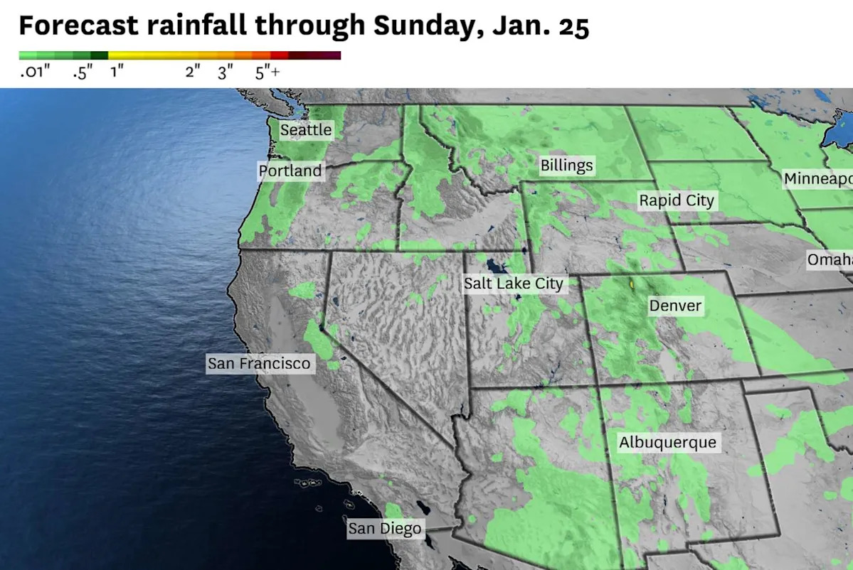
Below-normal precipitation is favored for the next 10 days as storms remain far away from California.
Without strong jet stream winds to push weather systems along, the current pattern will remain locked in place. Patchy fog will linger in the Central Valley, with partly to mostly sunny skies everywhere else. Monday’s Bay Area events honoring the Rev. Martin Luther King Jr. will feature tranquil weather with temperatures in the 60s.
The only difference from last week to this week will be the presence of a weak low-pressure system cut off from the storm track. It won’t have much moisture to work with, and its motion will primarily be in the middle levels of the atmosphere. Little change in winds is predicted at ground level.
While it will be weak, the cutoff low will be the closest thing to a weather disturbance California has contended with in nearly two weeks.
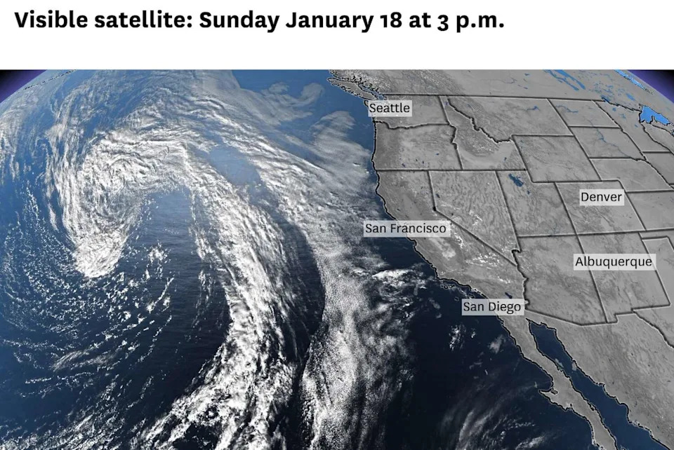
A low-pressure system over the eastern Pacific Ocean is predicted to cut off from the jet stream as it approaches California this week. It may generate a few light rain showers, most likely south of the Bay Area. (Baron/Lynx)
On Thursday, the cutoff low is forecast to nudge toward the California coast. If it spins close enough to San Francisco, the Bay Area could get hit by a light rain shower, but odds are low. Coastal areas from San Luis Obispo to San Diego have a better chance of picking up a tenth of an inch of rain through Friday.
While many people won’t see rain, the cooldown may be more noticeable. Temperatures will return closer to normal, in the upper 50s to low 60s in the Bay Area and 60s to low 70s in Southern California.
By the weekend, rain chances will fade as the cutoff low drifts away from California.
This extended spell of dry weather is not as dire as it would be in drought years. Fall and early winter brought an onslaught of storms and the state’s reservoirs are in good shape, but winter rain, and especially snow, are important buffers for wildfire season.
Stormy weather may finally return to California in the final few days of the month. The jet stream is predicted to strengthen around Jan. 28, which would bring a better chance of rain and mountain snow to the West Coast through early February.
Monday and Tuesday breakdown
San Francisco: Another 60-degree day is expected Monday, which would be San Francisco’s 10th conductive day of 60 degrees or warmer. The warmest parts of the city, around the Mission District and West Portal, could reach the upper 60s. A few high clouds may add some flair to the sky at sunrise and sunset. Lows will be in the upper 40s to low 50s. Shave a couple degrees off Monday’s high temperatures, and that will be the only change in the weather Tuesday.
North Bay: Monday will start with patchy fog in the morning before a mostly sunny afternoon. Highs will range from the mid-50s near the delta to the upper 60s at the coast. San Rafael, Napa and Santa Rosa should reach the low to mid-60s. Winds will be light out of the northeast at 5 to 15 mph, gusting up to 35 mph in the hills. Similar conditions are expected Tuesday, although morning fog may be more widespread.
East Bay: Mostly sunny skies will prevail along the bay shoreline, with high temperatures in the low to mid-60s west of Interstate 680 and mid- to upper 60s to the east. Tuesday’s temperatures will be similar. East of the Caldecott Tunnel, Monday will start with patchy fog near the delta, but sunshine is expected to prevail by late morning. Highs will be in the low to mid-60s. Fog may be more widespread Tuesday morning, which would cap temperatures in the 50s. Overnight lows will be in the 40s in the valleys and low 50s in the hills. Winds will be light out of the northeast Monday and Tuesday.
Pacific Coast and Peninsula: Temperatures will continue to be about 5 to 10 degrees above normal. Monday’s highs will be in the low to mid-60s in Daly City, San Bruno and South San Francisco and the mid- to upper 60s in San Mateo, Redwood CIty, Half Moon Bay and Pacifica. On Tuesday, temperatures are forecast to drop by a few degrees, but it’ll still be warmer than a typical January day. A mix of sun and clouds is expected both days, with winds out of the northeast. Overnight lows will be in the 40s.
South Bay and Santa Cruz:Another 70-degree day is expected in parts of the South Bay and Santa Cruz County on Monday. It’ll be gorgeous weather for hiking, beachgoing and other outdoor activities, with light winds and mostly sunny skies. Places that don’t hit 70 will still be plenty warm, in the mid- to upper 60s. Temperatures will cool 3 to 5 degrees Tuesday, especially along the coast as the offshore winds shut down, but highs will still be above normal for January. Nighttime temperatures will be in the 40s in Santa Clara Valley, with a big range from the upper 30s to upper 50s in the Santa Cruz Mountains.
This article originally published at California weather: How long will extended dry spell continue?.