
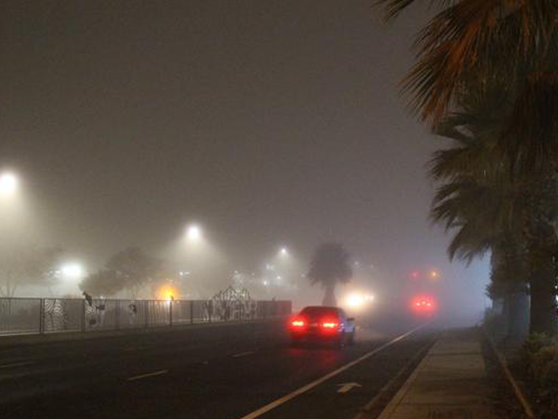
Drivers around Sacramento and the Central Valley have been unable to escape a particular weather phenomenon for the past couple weeks.
Blankets of dense grey fog have hung around the region bringing down the mood, obstructing visibility and creating potentially dangerous travel conditions.
But the fog has also been patchy at times, and higher-elevation areas like the foothills have largely been free from these low clouds and staying in the sunshine.
KCRA meteorologist Ophelia Young spoke with Insight Host Vicki Gonzalez about the conditions creating the gloom, and potential relief that could be on the horizon this weekend.
This interview has been edited for length and clarity.
Interview highlights
Is there a concrete definition for what’s considered “fog?”
Fog is basically a cloud that forms at the ground. [Fog] is officially defined as impacting visibility, reducing it down to a kilometer… about five-eighths of a mile. And dense fog is considered visibility down to a quarter-mile or less.
Why does fog sometimes get different names, like in the Bay Area or the valley?
The Bay Area fog that comes in at the coast, that is an “advection fog.” And the fog we have here in the valley is “radiation fog.” That kind of boils down to how the fog is formed. In the Bay Area their advection fog means warm and moist air coming in off the ocean… it travels horizontally from the ocean on-shore. And as that moist air travels on-shore, the base of that cools, condenses and it turns into fog.
The fog that we have here in the valley is air that’s already here. However it cools, especially overnight — that’s why fog is thickest in the morning. And when it reaches a point where it can no longer hold vapor all of that moisture condenses onto particulates, sometimes that could be pollution, and it turns into fog.
Sacramento has been reporting poor air quality in recent days. How does that potentially contribute to more fog?
It makes fog settle in earlier, lasts longer and also when it does develop, develops thicker. Pollution has built up day-after-day these last couple of weeks just from daily urban activities. That all produces surface faces for vapor to condense on and become fog. So when the air does cool to that dew point, there is just more of it.
Last weekend didn’t seem as foggy, and the sun did pop out for a while, but then it got thicker at the start of the week. What causes the conditions to change between days, and why does the fog burn off in the afternoons?
Cooler air can’t hold as much vapor. Warmer air can hold more water vapor, so that allows the fog droplets to evaporate.
When warm air is already up top, there isn’t much movement in-between the layers. You have the cool air sitting at the bottom, and it doesn’t mix out well. So, that warm air is also sinking down to the surface. It acts like a lid, it traps it in. We’re sitting in a valley, so of course this bowl makes it so that fog has nowhere to go.
That high pressure did weaken over the weekend, and allowed some minor disturbances in the atmosphere to move in. That sort of weakened the “lid” or the inversion, as we call it, and that allowed for that fog to more easily mix out during the afternoons.
If you drive from Sacramento into the foothills, for example, there’s a break from the fog. Why is that? Is it just because we’re at a lower elevation?
We talk a lot about this inversion. Temperatures normally cool as you go up in the atmosphere. What this inversion is, is that [air] warms instead as we go up in the atmosphere. So the air a little higher up is actually warmer than what we are experiencing here at the surface.
When you are driving into the foothills, and all of a sudden you see the fog disappear… that is because you have hit that layer of the atmosphere where it has started to warm. That warm air holds that cold air down to the surface; you’re just traveling from that cooler, denser layer into that warmer, lighter layer sitting up top.
Fog can make driving tricky. What are some safety tips for people getting on the road?
I think that’s why it’s important to pay attention to your local forecast, right? When we’re telling you there might be dense fog in the area, that doesn’t necessarily mean you’re going to walk out of the door and you’re going to hit dense fog right away. The area that you are in might be clear and as you’re driving, that fog is patchy. It’s crystal clear and maybe 15 minutes later we’re just completely socked in… that’s how quickly visibility can drop.
Maintain your following distance, make sure that you’re giving yourself enough room between you and the car in front of you. And it’s important to use your low beams. A lot of people think, “it’s bright now, we can turn off the low beams.” That’s not true because the low beams not only help you continue to see better in the fog, even during daylight hours, but it allows other people to see you and which direction you are headed.
Is any relief coming?
There are some changes in the atmosphere. We do have this area of low pressure, it is going to move out east… but here that is removing the “lid” that we have that’s responsible for the fog and the haze. And it’s the first of a couple disturbances that we’re anticipating these next couple of days.
What we really need now is some breezes to mix out that fog layer. I think that we’re going to get that Friday night through Saturday, and then on Sunday we’ll wake up to some clearer air in the morning.
CapRadio provides a trusted source of news because of you. As a nonprofit organization, donations from people like you sustain the journalism that allows us to discover stories that are important to our audience. If you believe in what we do and support our mission, please donate today.