
New York City, Long Island and Westchester County are under a state of emergency due to a powerful nor’easter that’s impacting the region through Monday.
The National Weather Service has issued Coastal Flood Warnings for Long Island, New York City and Westchester County through 8 p.m. Monday.
“As the Nor’easter continues making its way through New York, I’m declaring a State of Emergency across boroughs and counties most impacted by the storm,” Gov. Kathy Hochul said in a statement Sunday. “The safety of New Yorkers is my top priority, and I continue to urge extreme caution until the storm has passed through the state.”
The governor said the state had been working closely with county and city partners on storm preparations.
Mayor Eric Adams thanked the governor and her team in a post on X. He added, “All our teams here locally are working around the clock with our state partners to ensure New Yorkers are informed and safe. We’ll continue to keep you updated as new information is available.”
New Jersey has also declared a state of emergency, as the storm is causing high surf and coastal flooding along the Jersey Shore.
Storm takes down trees in NYC

Strong winds brought a tree crashing down onto a car in Queens on Oct. 12, 2025.
CBS News New York
New York City’s Office of Emergency Management posted on social media early Monday, saying 102 trees had fallen citywide, as wind gusts reached up to 46 mph.
Sunday’s winds brought down a massive tree in Laurelton, Queens. The tree, which appeared to be rotted out, collapsed onto Nora Garayua’s car on 228th Street between 137th and 138th avenues.
“I literally went food shopping, and I came back in a taxi and there was a tree on my car,” Garayua said. “Had it cracked a little farther, it would have hit either of the houses.”
Parts of the same tree landed on a vehicle in her neighbor’s driveway.
“Nobody’s hurt, but yeah, it sucks. I didn’t know the winds were that bad,” neighbor Alana Roberto said.
“All these trees around here are rotten. They have holes in them, all these trees. They don’t do nothing until– somebody have to die or something, injured or whatever,” neighbor Patrick Brown said.
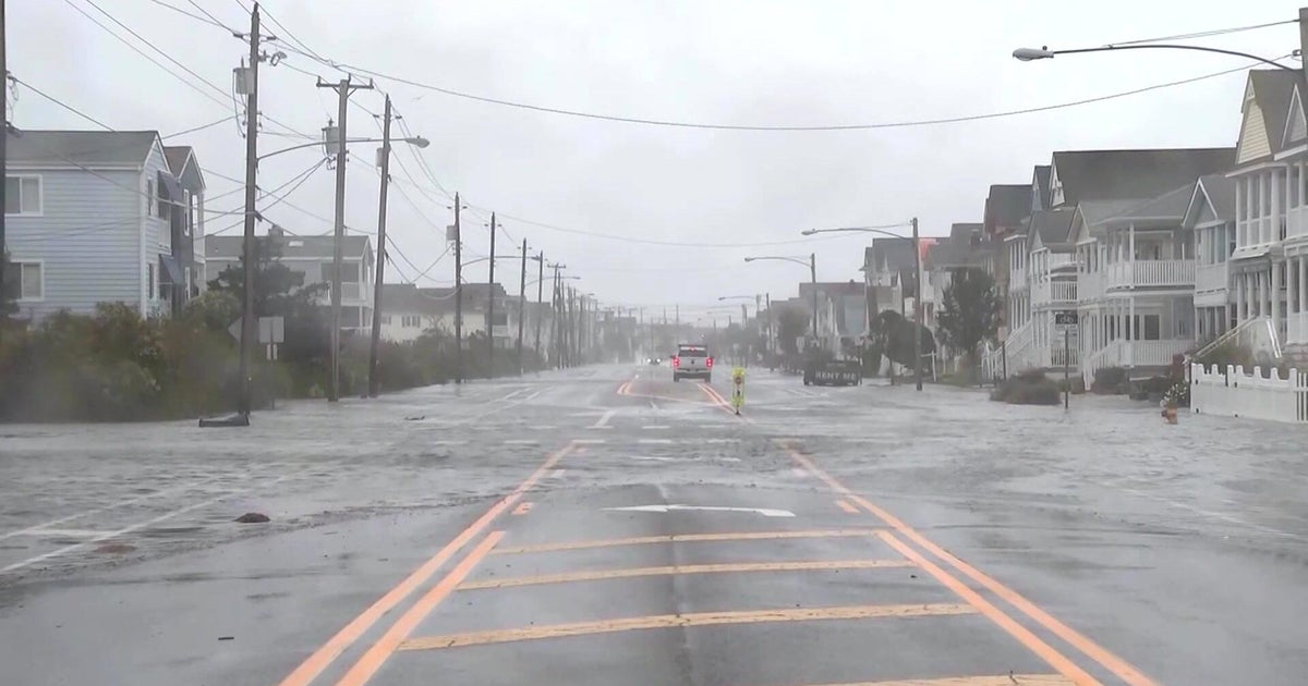
High winds, high tide concerns on Long Island

CBS News New York
Coastal communities on Long Island are bracing for a one-two punch of high winds and flooding. The next high tide cycle is expected around 1 p.m. Monday for south shore beaches, and then around 4 p.m. on the north shore.
Nassau County Executive Bruce Blakeman gave an update on the county’s storm response Monday, reminding residents it isn’t over yet. He said crews are keeping a eye on south shore communities, particularly in Freeport, Long Beach and Merrick.
“There will be flooding on both the north shore and the south shore — light to moderate on the north shore, could be major in some vulnerable areas. On the south shore, it will be moderate to heavy, ” Blakeman said.
The winds have been constant in Long Beach and the rain continues to pound down, creating dangerous conditions near the coast. The last high tide was reported between 1 and 4 a.m. overnight, leading to coastal flooding in some low-lying areas.
CBS News New York also spoke with Suffolk County Executive Ed Romaine for an update on conditions there Monday. He said coastal flooding remains a concern at high tide, as well as winds up to 60 mph out in Montauk.
“We know that the rain is going to continue. We know that the surf has been very hard and pounding away, which means erosion for us and beach loss,” Romaine said.
On Sunday, Romaine said the biggest area of concern was Fire Island, along with other low-lying areas in Mastic Beach, East Patchogue and Lindenhurst.
“The ferries stopped running to all of Fire Island as of noon [Sunday], and ferries will not run again ’til Tuesday, so if you’re on Fire Island and you need help, call 911,” he said.
He also urged drivers to stay off the roads, if possible.
“This is a storm that we’re holding our breath and hope it isn’t as bad as predicted,” said Romaine.
N.J. sees coastal flooding along the Jersey Shore

A nor’easter is causing some coastal flooding in communities along the Jersey Shore.
CBS News New York
Emergency officials warn portions of the Garden State are forecasted to experience moderate to major coastal flooding, along with sustained winds of up to 60 mph and high surf, potentially causing significant beach erosion and dune breaching.
Several hours after the first high tide Sunday in North Wildwood, water filled the beach, and it was almost up to the boardwalk at Lincoln Avenue. In Avalon, water poured into the streets, making them look like rivers. Many neighborhoods near the back bay remained flooded Monday morning.
CBS News New York checked in with officials from Hudson and Monmouth counties early Monday, who reported some downed trees and localized flooding in the usual places, but no major damage so far. They asked people to continue to use caution on the roads.
Fire departments along the coast have high water vehicles staged and ready to go in case rescues or evacuations are needed.
Families say they are ready for the worst – having stocked up on food and batteries, secured outside furniture and moved their vehicles to higher ground.
Live radar shows nor’easter moving through region  CBS New York Power outages across New York
Forecasters warned the high winds have the capability of bringing down branches and power lines.
Local utilities began reporting outages early Sunday evening, and thousands of customers remain without power Monday.
PSEG Long Island has approximately 3,271 customers without power in Nassau and Suffolk counties, Orange and Rockland has about 4,217 customers out in Westchester County, while JCP&L and PSE&G report about 14,381 combined outages in New Jersey.
According to Hochul’s office, more than 7,000 utility workers are available across the state in anticipation of power outages, and crews were prepared to work overnight if necessary.
To report an outage, call:
Central Hudson: 800-527-2714Con Edison: 800-752-6633National Grid: 800-867-5222NYSEG: 800-572-1131O&R: 877-434-4100PSEG-LI: 800-490-0075RG&E: 800-743-1701Travel impacts around NYC area
All three airports in the New York City area reported weather-related delays Sunday.
On the roads, video showed heavy flooding on parts of the Van Wyck Expressway early Monday morning.
The MTA says empty tractor-trailers and tandem trucks are banned across the city’s seven bridges and tunnels through 6 p.m.
The agency also prepared for possible flooding in the subway system, focusing on 20 stations. Crews put down vent covers since drains are not designed to hold large amounts of water. They said the covers prevent 80% of the water from getting in.
“We have overtime staff that’s gonna stay behind to help with the conditions, any water conditions that we have,” said Cylieah Tate, superintendent for facilities at the Department of Subways.
NJ Transit announced multiple changes to service in anticipation of the storm, including the suspension of the 319 bus route between New York, Atlantic City and Cape May. The North Jersey Coast Line is also suspended Monday between Bay Head and Long Branch, and the Atlantic City Line is suspended between Atlantic City and Philadelphia.
Meanwhile, the Montclair-Booton Line is running with 30-minute delays due to a tree on the tracks near Glen Ridge.
Metro-North is also suspended on the New Haven Branch due a a tree on the overhead wires near Springdale.
CLICK HERE for the latest MTA service changes, and HERE for updates from NJ Transit.