
Northern California forecast: Another warm day before the cooling trend begins
More sunshine and mild temperatures are forecast for Tuesday, but clouds and cooler air arrive tomorrow.
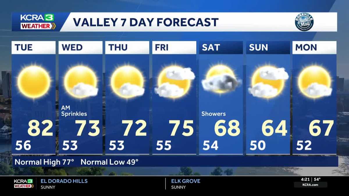
OR IF THERE ARE MORE THAN ONE. WELL, 14 IS YOUR TIME. TIME TO TALK WEATHER ONCE AGAIN, TAKING A LIVE LOOK OVER DOWNTOWN SACRAMENTO. LET’S HEAD BACK OVER TO METEOROLOGIST TAMARA BERG AND LET’S TAKE A TOUR NOW OF STOCKTON AREA. SO FROM SACRAMENTO INTO STOCKTON, YOU’LL NOTICE THAT THE SKIES AGAIN REALLY, REALLY CLEAR. THIS IS A GREAT VANTAGE POINT FOR YOU. AND ALSO NOTICE THAT THE FLAG GETTING A LITTLE BRUSH UP ON OCCASION. THAT IS DUE TO THAT LIGHT AND SUBTLE NORTH WIND. IT’S NICE COOL STRETCH OUT THERE FOR THE MORNING. YOU’RE WAKING UP INTO THE LOW 50S HERE IN THE VALLEY TO THE UPPER 20S IN THE SIERRA, AND THAT’S A BIT OF A DROP OFF COMPARED TO 24 HOURS AGO, ESPECIALLY YUBA CITY. YOU’RE DOWN TO EIGHT DEGREES COOLER THAN THIS TIME YESTERDAY MORNING. WE’RE RUNNING FOUR DEGREES COOLER IN SACRAMENTO, TWO DEGREES DOWN IN STOCKTON. THE ONLY SPOT I’M SEEING THOSE NUMBERS UP A LITTLE BIT IS ALONG THE FOOTHILLS. YOUR FORECAST FOR THE MORNING AGAIN, CLEAR SKIES, DAYBREAK. NOT UNTIL 721. SUNSET. TONIGHT IS AT 619. AND THAT SKY LOOKING AGAIN PRETTY MUCH PRETTY DARK FOR THE MORNING. THANKS IN PART TO THE NEW MOON PHASE WHERE THAT MOON IS SHRUNK DOWN QUITE A BIT, YOU CAN BARELY SEE THE SLIVER OF IT IN THAT EARLY MORNING SKY. IT’S ALSO A GREAT MORNING TO TRY TO CHECK OUT SOME OF THE SHOOTING STARS OR THE ORIONIDS METEOR SHOWER THAT’S TAKING PLACE BEFORE THE SUN COMES UP. TODAY WILL BE A BRIGHT DAY WITH WARM CONDITIONS, HIGHS PUSHING TOWARDS LOW 80S. WE STILL HAVE A LITTLE BIT OF THAT NORTH BREEZE AROUND FOR THE VALLEY TODAY. IN THE FOOTHILLS WE’LL HAVE LIGHT AND VARIABLE WIND CONDITIONS. TEMPERATURES WARM YET AGAIN. WE’RE GOING TO PUSH TOWARDS THE UPPER 70S CLOSE TO THAT 80 DEGREE MARK FOR MOST OF YOU. AND TODAY, IN THE FOOTHILLS, FROM THE FOOTHILLS TO THE SIERRA PLAN FOR SUNSHINE, AND WE’RE TOPPING OUT CLOSE TO 70 DEGREES, WE DO HAVE HIGH PRESSURE, WHICH HAS KIND OF BEEN THE DOMINANT FEATURE, KEEPING US HIGH AND DRY, KEEPING US WITH THOSE CLEAR SKIES. BUT THERE’S A DISTURBANCE SPINNING JUST OFF THE COAST HERE OF SOUTHERN CALIFORNIA, AND THAT’S GOING TO START TO WORK ITS WAY TO THE NORTH AND NORTHEAST AS IT STARTS TO SLIDE INTO OUR REGION, ESPECIALLY TONIGHT, WE’LL NOTICE A BIT MORE OF AN INFLUX OF CLOUD COVER. 11:00 TONIGHT, YOU CAN SEE THOSE CLOUDS STREAMING UP FROM THE SOUTH. AND I WOULD NOT BE SURPRISED IF SAN JOAQUIN COUNTY OR STANISLAUS COUNTY DOES SEE A FEW SPRINKLES IN THE OVERNIGHT. WE COULD SEE A BETTER CHANCE FOR MAYBE A FEW SPRINKLES BEFORE THE SUN COMES UP AROUND THE SACRAMENTO REGION TOMORROW MORNING. AND THEN ALSO NOTICE THAT BATCH OF MOISTURE ROTATES ACROSS THE SIERRA. SO AREAS ALONG AND SOUTH OF HIGHWAY 50, MAYBE THE BEST CHANCE TO SEE A POTENTIAL MEASURABLE RAINFALL 10TH OF AN INCH OR LESS. WE’RE EXPECTING DURING THE DAY TOMORROW AND THEN THURSDAY THAT DISTURBANCE SLIDES OUT OF HERE, MOVES OFF TO THE EAST. WE’RE DRY THURSDAY AND FRIDAY. OUR NEXT CHANCE FOR MEASURABLE RAINFALL. PRETTY MUCH MORE WIDESPREAD, IS GOING TO BE ON SATURDAY. AND THEN ON SUNDAY WE’VE GOT A CHANCE FOR MOUNTAIN SHOWERS CONTINUING. AND MONDAY IT LOOKS LIKE THAT SYSTEM KIND OF FALLS APART AS IT STREAMS OFF TO THE EAST. FORECAST TEMPERATURES AGAIN. THIS IS THE WARMEST OF IT. BRANDY AT 82. PLAN FOR A COUPLE OF SPRINKLES, BUT NOTHING MEASURABLE IN THE VALLEY TOMORROW. BUT LOOK AT THAT DROP OFF. WE’RE GOING TO GO DOWN ABOUT 10 TO 12 DEGREES COOLER AROUND THE REGION TOMORROW AFTERNOON. WE HANG ON TO THOSE 70 STRAIGHT THROUGH THE END OF THE WORKWEEK AGAIN. WE’RE DRY THURSDAY AND FRIDAY, BUT SATURDAY, LOOKING AT A CHANCE FOR SOME SHOWERS. SO IF YOU HAVE OUTDOOR PLANS SATURDAY, I WOULD SAY DON’T CANCEL THEM, BUT BE MINDFUL OF THE CHANGEABLE FORECAST
Northern California forecast: Another warm day before the cooling trend begins
More sunshine and mild temperatures are forecast for Tuesday, but clouds and cooler air arrive tomorrow.

Updated: 5:35 AM PDT Oct 21, 2025
More sunshine and mild temperatures are forecast for Tuesday. Afternoon highs in the Valley will reach the upper 70s and low 80 while the Foothills sees highs in the mid and upper 70s and low 70s are forecast for the Sierra. A weak system moves over the region Wednesday bringing clouds, cooler temperatures, and a few sprinkles, mainly in the Sierra and south of Hwy 50. Dry conditions will slightly below normal temperatures are expected Thursday and Friday. A stronger system pushes into the Pacific Northwest Friday night and into the weekend. We may see rain and snow for the southern end of this system though the exact timing and precipitation amounts are still uncertain. Check back for more updates throughout the week.
SACRAMENTO, Calif. —
More sunshine and mild temperatures are forecast for Tuesday. Afternoon highs in the Valley will reach the upper 70s and low 80 while the Foothills sees highs in the mid and upper 70s and low 70s are forecast for the Sierra.
A weak system moves over the region Wednesday bringing clouds, cooler temperatures, and a few sprinkles, mainly in the Sierra and south of Hwy 50.
Dry conditions will slightly below normal temperatures are expected Thursday and Friday.
A stronger system pushes into the Pacific Northwest Friday night and into the weekend. We may see rain and snow for the southern end of this system though the exact timing and precipitation amounts are still uncertain. Check back for more updates throughout the week.