
The Bay Area’s warm, dry stretch has spilled into February. Aside from a paltry 0.13 inches of rain on Jan. 27–28, the region has gone weeks without meaningful precipitation.
The pleasant weather in the Bay Area and across much of California comes with a cost. It’s quietly eating away at one of the state’s most critical water supplies.
Just three weeks ago, the statewide snowpack stood at 89% of its historical average after a burst of late December and early January atmospheric rivers. Since then, it has collapsed to 59%, according to Thursday’s survey by the California Department of Water Resources at Phillips Station. Sierra snowpack levels currently show a sharp north-to-south divide. Electronic readings put the Northern Sierra at just 43% of average, with the Central and Southern regions at 60% and 78%, respectively.
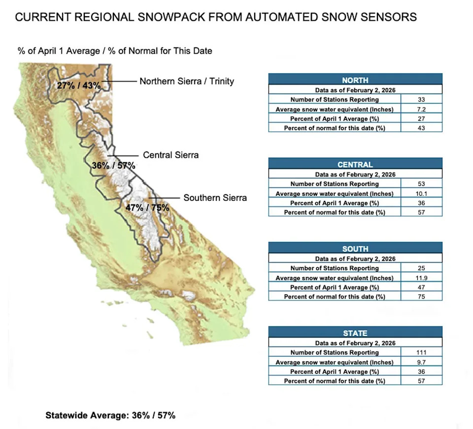
California’s snowpack is lagging behind as of Feb. 2, with the statewide average sitting at 57% of normal for the date and 36% of the April 1 peak. (CDWR)
The culprit isn’t a lack of overall precipitation. The majority of Northern California is still running above average for the current water year.
The issue is timing and temperature. January, typically one of California’s wettest months, was dominated by warm, dry weather that steadily melted what the Christmas and New Year’s storms delivered. No significant precipitation is expected for at least the next two weeks.
That dry pattern will be on full display this week, providing excellent weather for Super Bowl week events, but exacerbating the overall problem. A stout ridge of high pressure will dominate this week and will push temperatures well above normal through at least Wednesday.
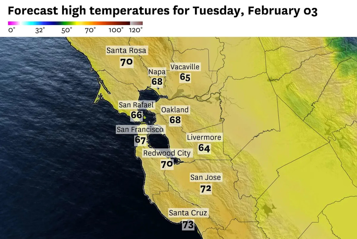
Tuesday’s highs across the Bay Area will run 5 to 10 degrees above average, with mid- to upper 60s common and low 70s likely in the South Bay. By Wednesday, Oakland could tie or exceed its daily record high of 70 degrees, while parts of Southern California may flirt with 90 degrees.
In the Sierra, highs at ski resorts will climb into the 50s. Combined with strengthening February sunshine, the warmth will further thin an already fragile snowpack.
California isn’t alone. The same persistent ridge of high pressure driving our warmth has created snow drought conditions across much of the West. Salt Lake City has recorded just a tenth of an inch of snow this winter, with its all-time seasonal record low of 14 inches in jeopardy. Large swaths of Oregon, Nevada, Arizona and New Mexico are running below 50% of normal snowpack.
The silver lining is that California’s reservoirs are in solid shape after three consecutive wet winters.
Shasta is 80% full, running at 25% above normal. Oroville is 82% full, about 38% above normal. And 100% of the state remains drought-free. But snowpack acts as a slow-release reservoir of its own, supplying roughly 30% of California’s annual water needs as it melts through spring and summer. If the pattern doesn’t shift soon, that contribution will fall well short.
February and March are historically the Sierra’s snowiest months, so the season isn’t lost. For now, enjoy the warmth, knowing the mountains could use a lot less of it.
Tuesday breakdown
San Francisco: Patchy fog is possible in the morning, especially near the immediate coast, but it will burn off quickly. Expect a sunny and warm afternoon, with highs in the mid-60s in the Presidio, Sunset and Richmond districts and the upper 60s in the Mission, SoMa and downtown. Overnight lows will settle into the upper 40s under mostly clear skies.
North Bay: Another gorgeous day. Sunshine from start to finish across most of the region, with highs reaching the low 70s in Santa Rosa, Cloverdale and the upper Sonoma County valleys, 10 to 15 degrees above normal for this time of year. Napa and Petaluma will top out in the upper 60s. Overnight lows will dip into the upper 30s in the coldest valleys, with fog possible again near the delta and in sheltered spots around Novato and Petaluma.
East Bay: Sunny and warm conditions will be in place across the East Bay. Oakland and the bay shoreline will see highs in the upper 60s. The Tri-Valley will be a bit cooler, with Concord, Livermore and Pleasanton topping out in the mid-60s. A few high clouds may drift in by evening but won’t amount to anything. Overnight lows should be in the low to mid-40s, with patchy fog possible in the Livermore Valley before dawn.
Pacific Coast and Peninsula: Mostly sunny skies with temperatures split along the usual dividing lines. Redwood City and San Carlos along the Highway 101 corridor will be warmest with temperatures around 70 degrees. Even Pacifica and Half Moon Bay will warm into the upper 60s. Overnight lows should be in the mid- to upper 40s, with a slight chance of fog near SFO and along the bayshore.
South Bay: Fantastic conditions for Super Bowl activities as the South Bay will be the warmest part of the region. Temperatures will rise into the low 70s in San Jose and Santa Clara, with even warmer temperatures down towards Gilroy. Overnight lows will drop into the low 40s under clear skies, marking a 30-degree diurnal swing in some spots.
This article originally published at Why California’s snowpack is melting even after a wet start to winter.