
The ridge of high pressure that has dominated California’s weather since early January is finally showing signs of weakening. On the heels of a record warm December, January ended up near record warm as well, with a clear national dipole between the warm West and cooler East.
What the National Weather Service describes as a “major pattern change” is on the horizon. Forecast models anticipate an end to the 60- and 70-degree temperatures, with rain and snow returning to parts of California as early as Sunday, and a more significant precipitation window opening next week.
But the nature of the incoming storms raises a critical question: Will the precipitation fall where, and how, the state needs it most?
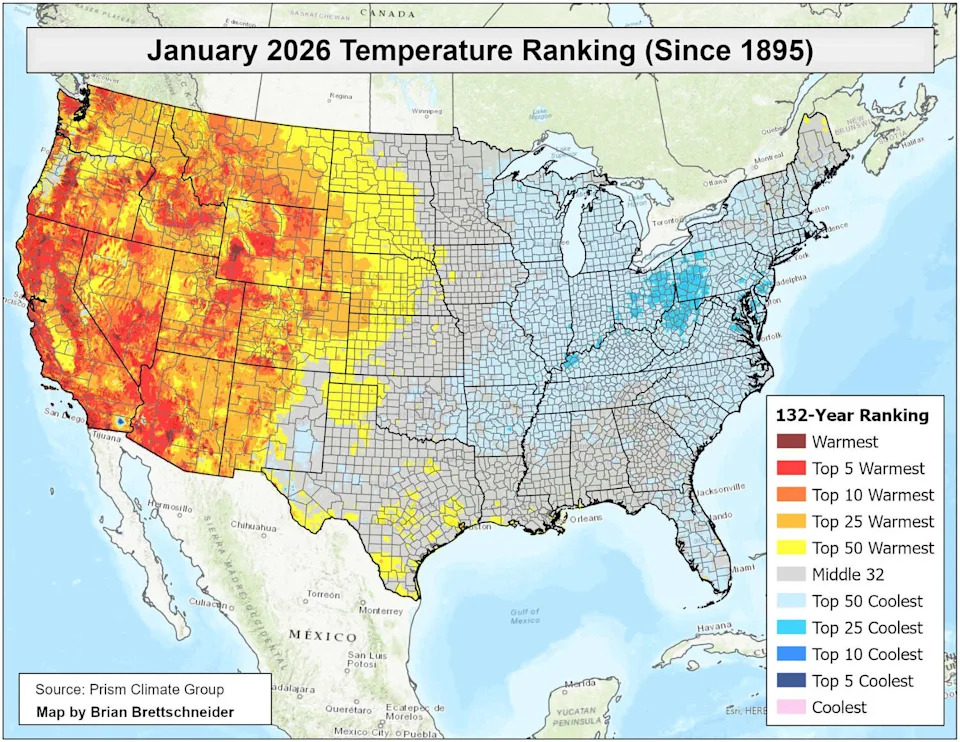
January continued a stretch of anomalously warm weather for the western half of the country. (Brian Brettschneider )
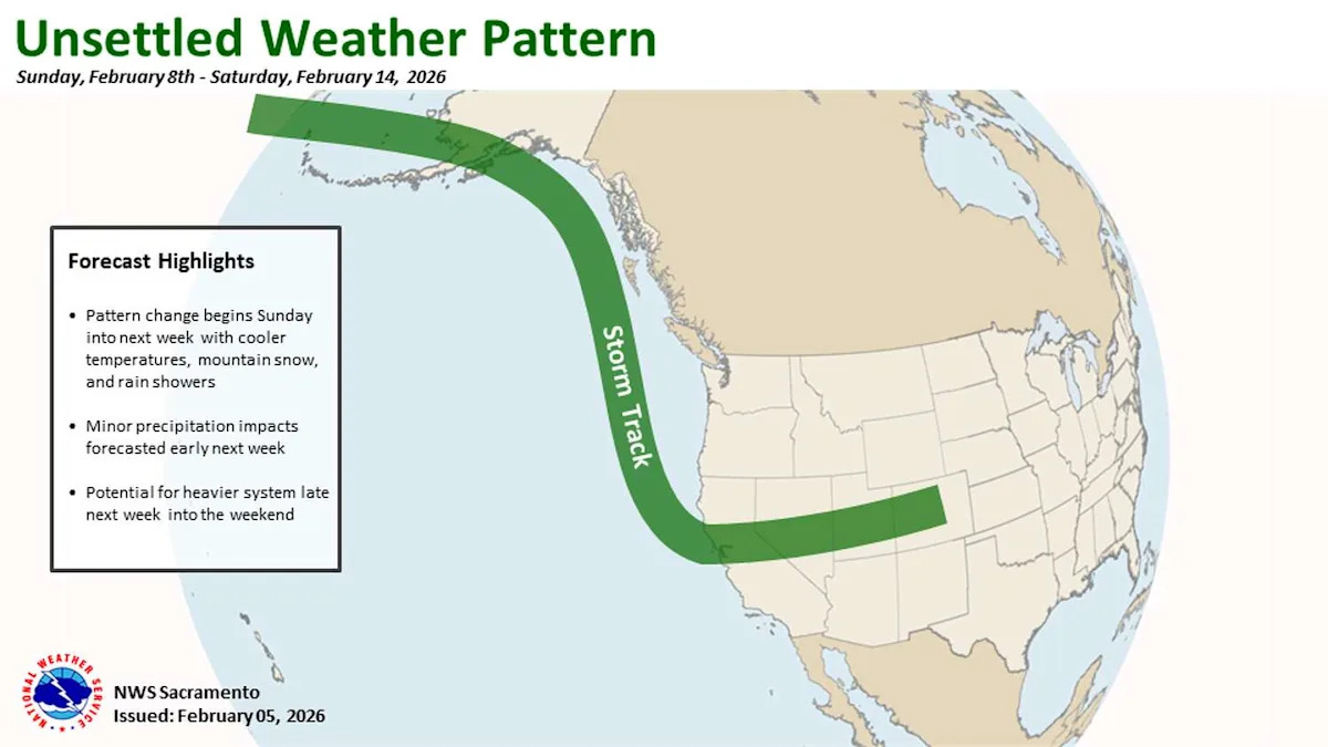
The first sign of the pattern change arrives on Sunday. A storm system spinning off the coast of the Pacific Northwest will push a cold front south down the California coast.
For the Bay Area, this will amount to very little. The chance for measurable rain in the region on Sunday stands at less than 20%, with the best odds focused on the North Bay and coastal mountains. That means that the Super Bowl winner should be able to celebrate in dry conditions.

The storm track will finally move back over California next week, but its orientation should result in relatively warm storm systems for the Sierra. (NOAA)
The more consequential pattern shift comes sometime around Feb. 10, when forecast models show a more complete breakdown of the ridge of high pressure. The European weather model, which has historically outperformed other guidance at this range for detecting large-scale pattern changes, is the most aggressive in breaking down the ridge and opening the door for a series of systems to reach California. Other models reach similar conclusions, but on differing timeframes.
The timing matters. The speed of the ridge breakdown will determine how much moisture reaches California and how far south the storm track extends.
Models are more in agreement on the chance of more substantial precipitation in the period roughly Feb. 12th through 18th. The Climate Prediction Center has posted slight risks for heavy precipitation along the California coast during that window, expanding southward from Northern California into the central and southern parts of the state by mid-month.
The atmospheric setup in this period should feature a more potent and longer-duration upper-level storm system capable of sending multiple shots of precipitation toward California.
But even as the storm door begins to crack open, the details of what’s coming through it point to a problem.
The systems arriving through mid-February are expected to approach from the northwest, bringing warm air with them. Snow levels could remain well above typical Sierra pass elevations, meaning precipitation that does reach the mountains will likely fall as rain at elevations where the state needs snow. That kind of setup doesn’t rebuild snowpack.
California’s statewide snowpack has dropped to roughly 57 percent of its seasonal average, with the Northern Sierra sitting at just 43 percent of normal. Warm rain on a depleted snowpack compounds the problem rather than reversing it.
The critical question for the second half of February is whether the later-period storms bring a different air mass. Even a modest shift in the storm track would lower snow levels and dramatically change the outcome in the Sierra. At this range, that remains unresolved.
For now, the ridge is still in control. But the models are, for the first time in weeks, showing a credible path toward the end, even if the first storms to replace it may not bring exactly what the mountains need.
Weekend outlook
San Francisco: Clouds will finally return to the city on Friday and should persist into the afternoon when some sunshine should pop out with temperatures settling in the low to mid-60s. Saturday will feature similar conditions, with clouds in the morning and partial sunshine in the afternoon with temps in the 60s. Onshore flow in the afternoon should keep things cooler at the coast. Clouds will likely hang around longer on Sunday as the day may end up overcast. Temperatures will be in the low 60s. Overnight lows each night will be in the upper 40s to low 50s.
North Bay: Friday morning fog is likely in the interior valleys. Santa Rosa, Petaluma and Napa could see dense patches before things clear out by midday. Afternoon highs will land in the mid to upper 60s across the region under partly cloudy skies. Saturday looks similar with areas of fog lingering into the morning and highs in the mid-60s. Sunday is where things get more interesting. Clouds will build through the day and a chance of light rain will develop by the late afternoon and evening, making the North Bay the most likely part of the region to see measurable precipitation this weekend. Highs will be in the low to mid-60s. Overnight lows will drop into the mid-40s to low 50s, with the coldest readings in the inland valleys.
East Bay: Friday and Saturday will feature partly cloudy skies in the afternoon with highs in the upper 60s, still a few degrees above normal for early February. Patchy fog is possible in the Tri-Valley on Saturday morning but should burn off by midday. Sunday will turn mostly cloudy with an outside chance of rain showers. Highs will hold in the mid-60s and overnight lows will dip into the mid to upper 40s.
Pacific Coast and Peninsula: Friday and Saturday will be partly cloudy at the coast with highs in the mid 60s in places like Half Moon Bay and Pacifica. The bayside of the Peninsula will see a bit more sunshine and slightly warmer temperatures, with highs in the upper 60s. A High Surf Advisory is in effect through 9 p.m. Saturday with breaking waves of 17 to 22 feet and dangerous rip currents and sneaker waves. Sunday should be cloudier and cooler across the board with temperatures in the low to mid-60s. Overnights will feature some clouds and temperatures around 50 degrees.
South Bay: The South Bay will be the center of Super Bowl action over the weekend, and it should be the warmest part of the region as well. Temperatures on Friday and Saturday will be right around 70 degrees in San Jose and Santa Clara. Super Bowl Sunday will feature more clouds, but there should still be a bit of sunshine at kickoff, with temperatures in the upper 60s. Rain chances remain very low through Sunday night. Overnight lows will be in the mid-40s to low 50s.
This article originally published at California, West to see ‘major pattern change’ as rain, snow enter forecast.