
Winter roars back in Sacramento, with two storms bringing midweek rain and Sierra snow, followed by a colder, stronger system this weekend with heavy rain and wind.
SACRAMENTO, Calif. — Weather conditions forecast for the Sacramento region over the next week will be a far cry from the spring-like 70s and sunshine we had to begin February. We’ve got two storms on the way to Northern California, reminding us that winter is still very much here.
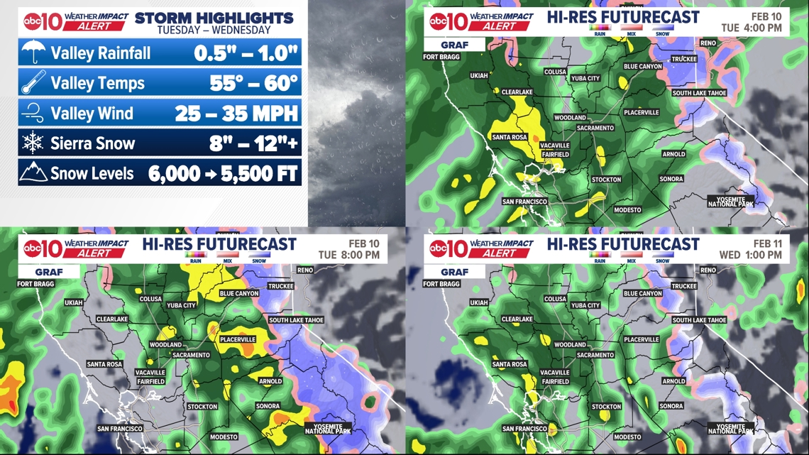
Off-and-on rain on Tuesday and Wednesday will keep conditions moderately wet for the next couple of days. It won’t necessarily be a washout, but it will be a big pattern shift from the 70s. Tuesday night, we could also see thunderstorms.
Up to a foot of snow at the high passes and Sierra ski resorts through Wednesday! Be ready for chain controls if headed up the hill midweek.
This is just the beginning. A break Thursday & Friday before a much bigger storm pushes in this weekend and continues through next week.
Storm number 2 will be much bigger, much colder, and much more impactful.

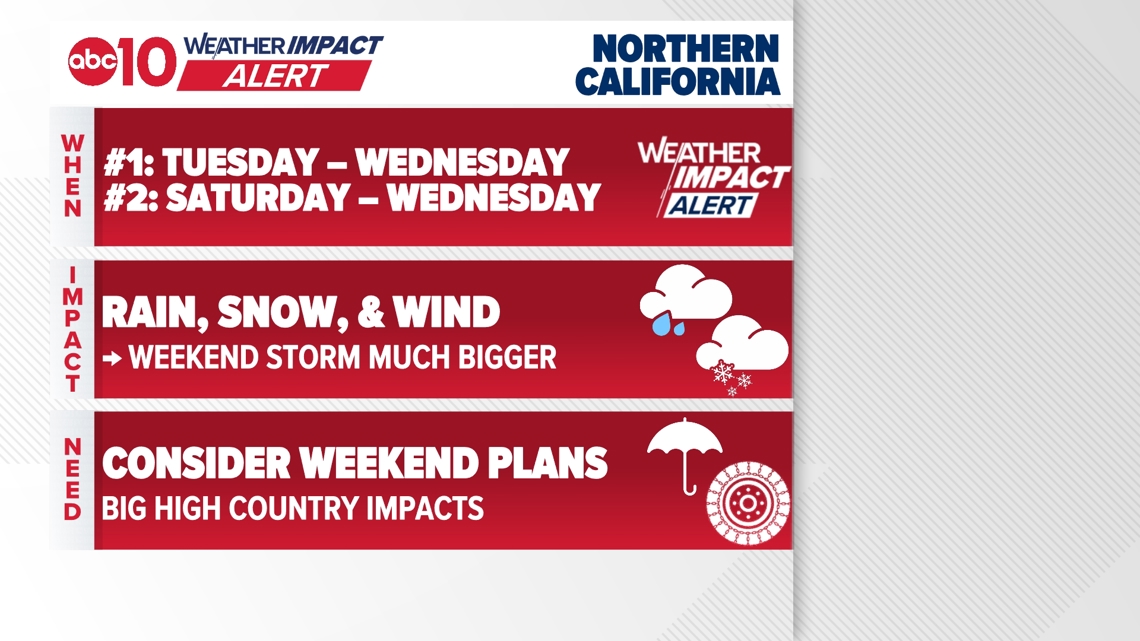
When
Storm #1 comes into Northern California on Tuesday and continues through Wednesday.
Thursday and Friday will be a break between the storms, with temps climbing back towards 60°.
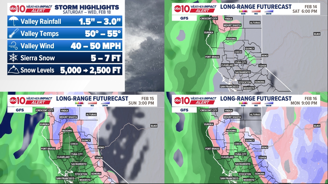
Storm #2 is expected to arrive on Valentine’s Day, likely in the afternoon or evening. This will be a long-duration storm. Moderate to heavy rainfall – and a few thunderstorms – are possible from the onset of the storm through Wednesday, February 18.
► Stay up to date with the forecast and weather impact team with the ABC10+ streaming app. Here’s how to download it for free.
Impact
Off-and-on rain on Tuesday and Wednesday will keep conditions pretty wet for the next couple of days. We’re expecting at least half an inch of rain in the valley, with most models showing about an inch. Not necessarily a washout, but enough to need the rain jacket and umbrella!
Up to a foot of snow at the high passes and Sierra ski resorts! Be ready for chain controls if headed up the hill midweek.
With storm #2 beginning over the long weekend, valley rainfall totals are likely to be between 1.5″ and 3.0″ by the end of the storm on Wednesday. That’s on top of whatever rain we get with storm #1.
Storm #2 will be a BIG snowmaker with very low snow levels! Snow levels will drop from around 5,000 feet to 3,000 feet. On Monday, snow levels could be as low as 2,500 ft.
Only a dusting that low, but at the passes we could see 5 to 7 feet! Ski resorts could see more than 7 ft. This is SERIOUS snow that will cause severe travel disruptions.
Lastly, it could be very gusty at times. Valley wind gusts of 40 to 50 mph are possible, with stronger gusts in the high country. This will lead to whiteout conditions.

Weather Impact Resources
► FORECAST DETAILS | Check out our hourly forecast and radar pages
► GET WEATHER ALERTS TO YOUR PHONE | Download the free ABC10 mobile app ► GO DEEPER | Stream in-depth weather forecasts and investigative reports with the free ABC10+ streaming app
► WEATHER IN YOUR EMAIL | Sign up for our daily newsletter
► MEET THE WEATHER IMPACT TEAM | Chief Meteorologist Monica Woods, Brenden Mincheff, Rob Carlmark
Need
Dig out the rain and snow gear. We’ve been dry for a while, but winter is back in a big way!
Tuesday and Wednesday will be the minor storms by comparison, but they’ll still have a range of impacts. In the valley, rain will make roads wet, so it may take longer to get around.
You’ll also want to have the umbrella with you through midweek. In the Sierra, chain controls are likely to be needed at some point. Driving will be difficult. Wind may lead to ski lift holds.
The bigger storm comes in over the weekend, and this one is likely to change a lot of plans! Whether that’s for Valentine’s Day dinner in the valley or for a long weekend ski trip, keep an eye on the forecast. Might be better to stay home, or at least dine indoors.
In the valley, moderate to heavy rain will keep things wet through the weekend and midweek. It could cause localized flooding, particularly in urban areas such as roads and parking lots.
Begin to reconsider Sierra travel from this weekend through next Wednesday. We’re expecting feet of snow – as much as 7 feet! – through Wednesday.
This will create difficult-to-impossible driving conditions. If you don’t absolutely need to travel in the high country, don’t. In addition to heavy snow, wind gusts of 50+ mph will occasionally cause whiteout conditions.
ABC10: Watch, Download, Read
For more ABC10 news and weather coverage on your time, stream ABC10+ on your TV for free:
► Roku – click here
► Amazon Fire – click here
► Apple TV – click here
GO DEEPER: The ABC10 Weather Impact Team investigates algae and bacterial threats to some of California’s largest natural lakes.