
Two mid-level troughs with associated surface low-pressure systems are forecast to impact California between February 14 and 19, bringing multiple rounds of precipitation across the state. Rainfall is expected across coastal and valley regions, with substantial snowfall in the Sierra Nevada.
The first trough is forecast to deepen as it propagates east toward the U.S. West Coast between February 14 and 15, while a surface low forms along the Oregon coast. That system is expected to deliver the first round of precipitation statewide.
Weak and short atmospheric river (AR) conditions may develop across central and southern California during this period, though less than 20% of West-WRF ensemble members indicate AR conditions reaching AR1 or higher between February 15 and 17.
The National Weather Service (NWS) Weather Prediction Center (WPC) forecasts 25–50 mm (1–2 inches) of precipitation across California for the 72-hour period ending 16:00 PT on February 16, with localized totals exceeding 50 mm (2 inches). Higher accumulations are expected over elevated terrain.
Uncertainty increases with the second trough forecast to deepen offshore between February 16 and 17. The West-WRF configuration initialized with the GFS shows earlier deepening farther offshore and higher precipitation totals over California compared to the ECMWF model.
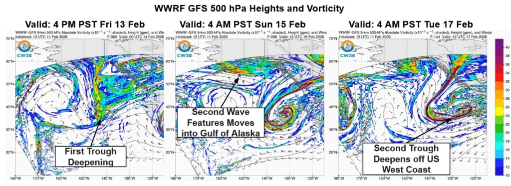 Image credit: CW3E
Under the West-WRF GFS scenario, over 130–200 mm (5–8 inches) of precipitation is forecast across the Sierra Nevada for the 72-hour period ending 16:00 PT on February 19, with 50–100 mm (2–4 inches) along the coast. The West-WRF ECMWF forecast more than 75–130 mm (3–5 inches) over the Sierra Nevada and 25–75 mm (1–3 inches) along the coast during the same period.
Ensemble spread remains large in 10-day precipitation forecasts for watersheds in the Sierra Nevada and the coastal regions of central and southern California. Both the GEFS and the ECMWF EPS forecast less than 75 mm (3 inches) and more than 175 mm (7 inches) over the Upper Yuba watershed.
Freezing levels over the Sierra Nevada are forecast to fall from approximately 2 900 m (9 500 feet) to near 1 500 m (5 000 feet) between February 14 and 18. The decline in snow levels is expected to rise proportionally to snowfall, particularly during the second trough.
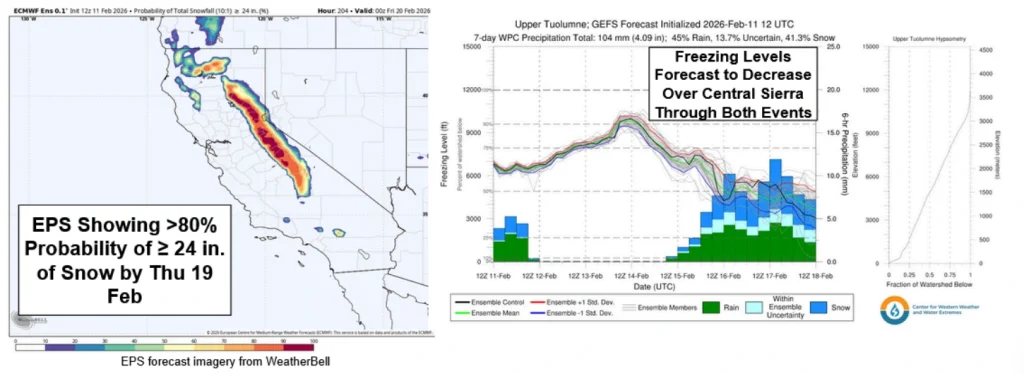 Image credit: CW3E
Both GEFS and EPS show probabilities exceeding 80% for snowfall accumulations of at least 60 cm (24 inches) across the Sierra Nevada by 16:00 PT on February 19. Such snowfall would contribute to improving the currently below-average snowpack across the region.
The Center for Western Weather and Water Extremes (CW3E) is planning Atmospheric River Reconnaissance flights to sample the trough structure and nearby atmospheric features to improve precipitation forecasts along the U.S. West Coast.
References:
1 Quick Look at the Active Weather Pattern Bringing Precipitation to California This Weekend into Next Week – CW3E – February 11, 2026