
Northern California forecast: Mild through Valentine’s Day, then storms return
Some areas of patchy fog will fade through Friday morning, making way for a sunny afternoon.
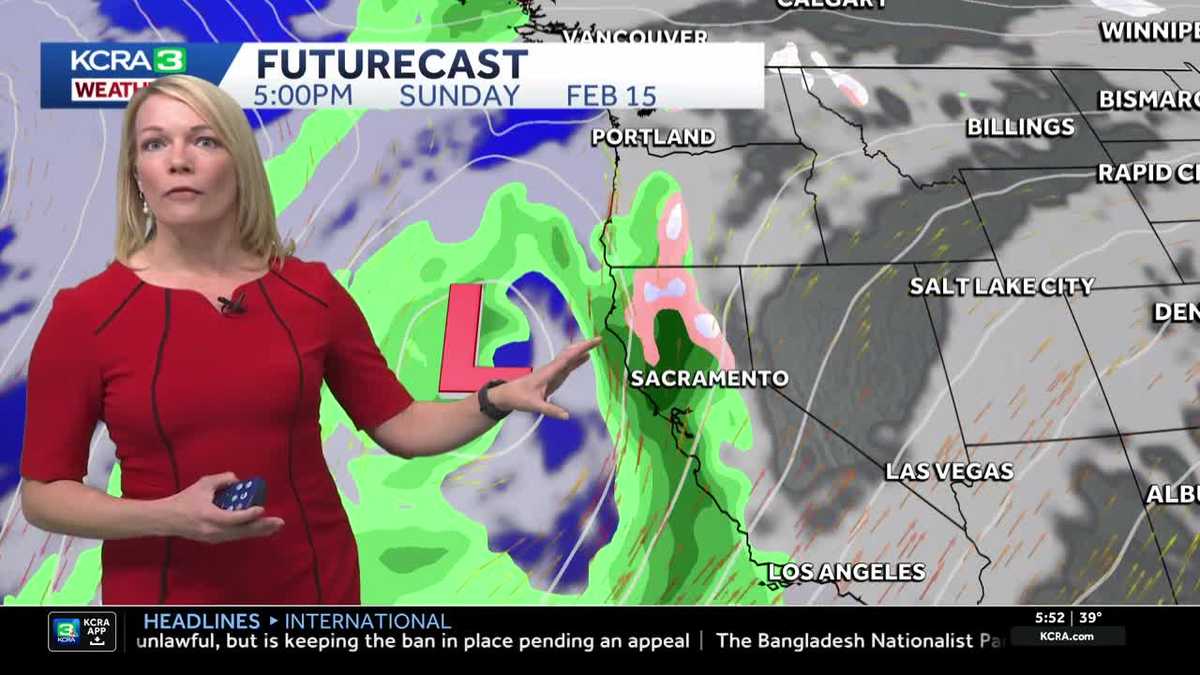
AND WE LOOK FORWARD TO YOUR REPORTS FROM CORTINA. ALL RIGHT. BYE, GUYS. ALL RIGHT, 550. LET’S TALK WEATHER HERE BACK AT HOME TAKING THIS LIVE. LOOK AT SUTTER HEALTH PARK. TAMARA IS HERE NOW. AND I MEAN, GOSH, WE’RE LOOKING AT WHAT IS ABSOLUTELY GORGEOUS THERE. YES. MUCH LIKE WHAT YOU JUST SAW THERE IN WHERE SHE’S AT. YOU’LL NOTICE THAT THE SUN IS OUT BLUE SKY. THERE’S SOME PASSING CLOUDS. THAT’S HOW OUR TAHOE FORECAST IS GOING TO LOOK FOR TODAY. BUT THAT WILL BE SHORT LIVED BECAUSE AS WE GET INTO THE BACK HALF OF THE WEEKEND ESPECIALLY, THAT’S WHEN THINGS WILL START TO STEER AND CHANGE UP PRETTY ABRUPTLY. RIGHT NOW, WE’VE GOT TEMPERATURES COOLING OFF. GRAB THAT THICK JACKET SACRAMENTO 39 DEGREES. HERE IN STOCKTON WE’RE DOWN TO 41 WITH SOME FOG TRYING TO DEVELOP AROUND THE PORT CITY. IT’S 43 MODESTO 22, IN SOUTH LAKE TAHOE. AND TODAY IS GOING TO BE A BEAUTIFUL WINTER DAY. TEMPERATURES A LITTLE BIT ABOVE NORMAL. THE NORMAL FOR THIS TIME OF YEAR FOR MID FEBRUARY, TYPICALLY 61. TODAY’S HIGH AIMING TO REACH 65. SO A VERY SIMILAR LOOK AND FEEL TO YESTERDAY. BUT THE CHANGES WILL START TO SLOWLY TRICKLE IN. WE’VE GOT SOME MUCH COLDER AIR THAT’S GOING TO WORK INTO NORTHERN CALIFORNIA, JUST IN TIME FOR THE BACK HALF OF THE WEEKEND. SO WHILE THINGS ARE DRY AND MILD THROUGH SATURDAY, THAT’S MY FORECAST GUARANTEE. RAIN IS EXPECTED TO RETURN LATE IN THE DAY ON SUNDAY, AND NOW WE’VE ELEVATED TO ALERT DAYS FOR BOTH MONDAY AND TUESDAY FOR GOOD. WIDESPREAD RAINFALL, HEAVY SIERRA SNOW AND OCCASIONAL GUSTY WINDS. NOW LET’S TIME THIS ALL OUT WITH FUTURECAST TO GIVE YOU AN IDEA ON HOW TO PLAN. SO AGAIN, FRONT HALF OF THE WEEKEND IS DRY, BUT BY SUNDAY, ESPECIALLY IN THE AFTERNOON, I’D SAY ANYTIME AFTER ABOUT LUNCHTIME WE COULD SEE THE RAIN DEVELOP, A MOVE INTO THE AREA, THEN IT BECOMES WIDESPREAD. ONCE THE SNOW BEGINS IN THE SIERRA, IT’S BASICALLY NOT GOING TO LET UP MONDAY, TUESDAY AND BY TUESDAY INTO WEDNESDAY, ANOTHER REINFORCING SYSTEM WITH COLDER AIR COMES IN. THAT’S WHEN THAT SNOW LEVEL COULD DROP AS LOW AS AROUND 3000FT. NOW, IN TERMS OF SNOWFALL ACCUMULATION, THIS IS ACCUMULATIVE FROM MONDAY THROUGH WEDNESDAY. I’M TALKING ABOUT 2 TO 5FT OF SNOW ABOVE 5000FT FOR THE VALLEY. THE RAIN WON’T BE AS IMPRESSIVE. AND THE TAKEAWAY HERE IS THAT WE’RE NOT GOING TO EXPECT TO HAVE ANY FLOOD CONCERNS NOW IN THE NEXT COUPLE OF DAYS, MONDAY AND TUESDAY. WE’VE GOT THOSE ALERT DAYS, BIG DROP IN TEMPERATURES AND YOU CAN SEE THAT CLEARLY PAINTED HERE FROM THE 60S OVE
Northern California forecast: Mild through Valentine’s Day, then storms return
Some areas of patchy fog will fade through Friday morning, making way for a sunny afternoon.

Updated: 6:23 AM PST Feb 13, 2026
Some areas of patchy fog will fade through Friday morning, making way for a sunny afternoon.Valley temperatures will warm into the mid 60s once again. Foothill temperatures will top out in the low 60s, with Sierra highs in the mid 40s. Winds will remain light.Similar weather will stick around for most of the daylight hours on Valentine’s Day. However, we’ll notice a light breeze pick up, and a few showers are possible late in the evening. Rain chances increase on Sunday, with showers and breezy winds spreading across the region.Monday and Tuesday are Weather Alert Days as two back-to-back systems move through Northern California. During both days, widespread, persistent, and occasionally heavy rain is expected. Damaging winds may gust to 50 mph. In the mountains, heavy snow will fall down to 4,500 feet on Monday, dropping to 3,000 feet by Tuesday evening.Storm impacts will wind down for the valley and foothills Tuesday night, but showers will continue Wednesday in the Sierra, with snow levels down to 2,500 feet by then.Drier weather is expected for the second half of the week.
SACRAMENTO, Calif. —
Some areas of patchy fog will fade through Friday morning, making way for a sunny afternoon.
Valley temperatures will warm into the mid 60s once again. Foothill temperatures will top out in the low 60s, with Sierra highs in the mid 40s. Winds will remain light.
Similar weather will stick around for most of the daylight hours on Valentine’s Day. However, we’ll notice a light breeze pick up, and a few showers are possible late in the evening. Rain chances increase on Sunday, with showers and breezy winds spreading across the region.
Monday and Tuesday are Weather Alert Days as two back-to-back systems move through Northern California. During both days, widespread, persistent, and occasionally heavy rain is expected. Damaging winds may gust to 50 mph. In the mountains, heavy snow will fall down to 4,500 feet on Monday, dropping to 3,000 feet by Tuesday evening.
Storm impacts will wind down for the valley and foothills Tuesday night, but showers will continue Wednesday in the Sierra, with snow levels down to 2,500 feet by then.
Drier weather is expected for the second half of the week.