
Tracking rain, snow and wind arriving in Northern California over the weekend and into next week
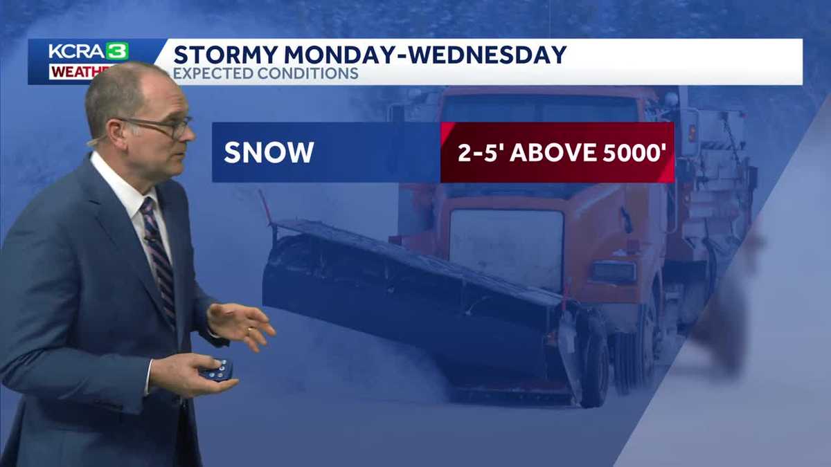
Nice and calm today and tomorrow. Clouds will increase overnight, making Saturday a cloudy day but no rain. Rain starts to move in Sunday morning, but the main band of rain doesn’t arrive until Sunday afternoon. Rain will continue overnight and into Monday with winds on the increase. The NWS has issued a wind advisory for the Sacramento Valley for Monday and Tuesday with winds 10-25 gusting 35-45 mph. Rainfall amounts are notable but not excessive. Localized street flooding possible, but creeks and streams should be fine. Snow will have the biggest impact with several feet of snow above 5000 ft and up to a foot or more around 4000 ft. Snow levels will drop below 3000 ft but it will stick best around 3000 ft. We have weather Alert Days Monday and Tuesday while Wednesday is an Impact Day.
HEADING INTO THIS WEEKEND SHOULD BE NICE. AND THEN THINGS ARE GOING TO CHANGE BIG TIME. YEAH, WE’RE LOOKING AT SOME CHANGES. WE’RE GOING TO GET BACK TO WINTER. THAT WINTER FEEL BECAUSE IT’S BEEN FEELING MORE LIKE SPRING LATELY. WE HAVE TEMPERATURES IN THE MID 60S THIS AFTERNOON RIGHT NOW, STILL FAIRLY COMFORTABLE OUTSIDE, 58 DEGREES IN SACRAMENTO, 56 IN STOCKTON, 60 IN MODESTO AND 36 DEGREES CURRENTLY IN TRUCKEE. WE HAD A DAYTIME HIGH IN SACRAMENTO OF 66 DEGREES. SO THAT’S FIVE DEGREES. WHAT WE TYPICALLY SEE THIS TIME OF YEAR, BUT STILL NOWHERE NEAR TEN DEGREES BELOW THE RECORD TEMPERATURES SET BACK IN JUST 2022. THAT WASN’T THAT LONG AGO. CLOUD COVER ON THE INCREASE. RIGHT NOW WE JUST HAVE THE HIGH THIN CLOUDS. BUT THERE’S A WEATHER SYSTEM OUT HERE AND IT’S BREWING. IT’S STIRRING THINGS UP OUT IN THE EASTERN PACIFIC. IT’S GOING TO MOVE INTO NORTHERN CALIFORNIA. SO WE HAVE THE WARM SECTOR THAT’S OUT AHEAD OF IT. AND SO THAT’S WHY TEMPERATURES ARE EXPECTED TO STAY IN THE 60S FOR SATURDAY. BUT THEN THE COLD AIR COMES IN BEHIND. AND THAT’S WHEN WE START TO SEE THOSE SNOW LEVELS DROPPING. HERE’S A LOOK AT FUTURECAST AND TIMING OUT THE RAIN. WE’LL SEE THE FIRST WAVE COMING THROUGH ON SUNDAY, BUT WE COULD SEE SOME AREAS GETTING RAIN AS EARLY AS SUNDAY MORNING. BUT THE HEAVIEST RAIN COMES THROUGH SUNDAY AFTERNOON. AND THEN WE HAVE A SLIGHT BREAK. BUT LOOK AT THE SNOW STILL PICKING UP IN THROUGH THE SOUTHERN HALF OF THE SIERRA. AND THEN ANOTHER WAVE COMING THROUGH. AND THIS IS GOING TO BRING THAT COLDER AIR WITH IT AS WE GET INTO TUESDAY. AND THAT’S WHAT WE SEE. SNOW LEVELS DROPPING DOWN CLOSER TO 3000FT. AND YOU CAN SEE PRETTY GOOD AMOUNT OF SNOW IS GOING TO BE FALLING AT THAT TIME AS WELL. AND ON ON WEDNESDAY, THAT’S WHEN THE COLDEST PART OF THIS COMES THROUGH. THAT’S WHEN WE COULD SEE THOSE SNOW LEVELS EVEN DROPPING A LITTLE BIT LOWER THAN 3000FT. AND THEN IT CLEARS OUT AND WE HAVE A BIT OF A NORTH WIND ON FRIDAY. AND LOOK WHAT RETURNS. AREA OF HIGH PRESSURE MOVES BACK INTO NORTHERN CALIFORNIA. AND THAT’S GOING TO KEEP THE RAIN AWAY FOR A WHILE. SO WE’RE GOING TO SEE SOME PRETTY GOOD ACCUMULATIONS THOUGH COMING OUR WAY OVER THE NEXT SEVERAL DAYS. SNOW. WE COULD SEE 2 TO 5FT ABOVE 5000FT. THAT’S A LOT OF SNOW COMING OUR WAY AS FAR AS SNOW LEVELS, DOWN TO ABOUT 2500FT IS WHAT WE’RE LOOKING AT. AND THEN ALSO WE HAVE SOME RAIN IN THE VALLEY, MOSTLY 1 TO 2IN, BUT SOME SPOTS COULD GET CLOSER TO THREE INCHES OF RAIN THROUGH THAT THREE DAY PERIOD, AND WINDS ALSO GUSTY, ESPECIALLY MONDAY AND TUESDAY. WE’RE LOOKING AT WIND GUSTS 35 TO 45MPH. HERE’S A LOOK AT THE SIERRA TIMELINE. WITH THE SNOW LEVELS DROPPING SUNDAY 5500FT BY MONDAY, DROPPING DOWN CLOSER TO 4000FT. AND THEN WE GET DOWN TO 3000FT ON TUESDAY AND WEDNESDAY COULD GET EVEN A LITTLE BIT LOWER. WE’RE LOOKING AT, AGAIN THE BULK OF THE SNOW COMING THROUGH MONDAY AND TUESDAY AGAIN, 12 TO 18IN BY DONNER SUMMIT ON MONDAY. THEN WE COULD SEE AGAIN UP TO THREE FEET OF SNOW ON TUESDAY. AND THEN WE’RE LOOKING AT AGAIN, MORE LIKELY JUST ABOUT A FOOT OF SNOW ON WEDNESDAY AS THAT COLDEST AIR ARRIVES. SO THAT MEANS IT’S GOING TO BE FLUFFY SNOW. IT’S NOT GOING TO BE THE HEAVY, WET SIERRA CEMENT THAT WE CAN GET. TEMPERATURES TOMORROW STILL WARMING INTO THE MID TO LOW 60S. SO NOT AS WARM AS TODAY, BUT STILL A VERY WARM DAY WITH CLOUDY SKIES. 61 IN FAIRFIELD, 58 IN AUBURN AND 46 DEGREES IN TRUCKEE. YOUR SEVEN DAY FORECAST SHOWS THE RAIN PICKING UP ON SUNDAY, THEN REALLY GOING TO TOWN THERE FOR MONDAY AND TUESDAY. SO WE HAVE THE ALERT DAYS ON THOSE DAYS. WEDNESDAY. STILL SOME SHOWERS LINGERING AND THEN CONDITIONS START TO CLEAR OUT THERE THURSDAY AND FRIDAY LOOKING PRETTY GOOD. AND THEN FOR THE SIERRA AND THE FOOTHILLS HERE’S YOUR FORECAST. TEMPERATURES ALSO IN THE UPPER 50S ON INTO THE FOOTHILLS, DROPPING OFF INTO THE 40S. AND
Tracking rain, snow and wind arriving in Northern California over the weekend and into next week
Nice and calm today and tomorrow. Clouds will increase overnight, making Saturday a cloudy day but no rain. Rain starts to move in Sunday morning, but the main band of rain doesn’t arrive until Sunday afternoon. Rain will continue overnight and into Monday with winds on the increase. The NWS has issued a wind advisory for the Sacramento Valley for Monday and Tuesday with winds 10-25 gusting 35-45 mph. Rainfall amounts are notable but not excessive. Localized street flooding possible, but creeks and streams should be fine. Snow will have the biggest impact with several feet of snow above 5000 ft and up to a foot or more around 4000 ft. Snow levels will drop below 3000 ft but it will stick best around 3000 ft. We have weather Alert Days Monday and Tuesday while Wednesday is an Impact Day.

Updated: 7:38 PM PST Feb 13, 2026
Nice and calm today and tomorrow. Clouds will increase overnight, making Saturday a cloudy day but no rain. Rain starts to move in Sunday morning, but the main band of rain doesn’t arrive until Sunday afternoon. Rain will continue overnight and into Monday with winds on the increase. The NWS has issued a wind advisory for the Sacramento Valley for Monday and Tuesday with winds 10-25 gusting 35-45 mph. Rainfall amounts are notable but not excessive. Localized street flooding possible, but creeks and streams should be fine. Snow will have the biggest impact with several feet of snow above 5000 ft and up to a foot or more around 4000 ft. Snow levels will drop below 3000 ft but it will stick best around 3000 ft. We have weather Alert Days Monday and Tuesday while Wednesday is an Impact Day.
Nice and calm today and tomorrow. Clouds will increase overnight, making Saturday a cloudy day but no rain. Rain starts to move in Sunday morning, but the main band of rain doesn’t arrive until Sunday afternoon. Rain will continue overnight and into Monday with winds on the increase. The NWS has issued a wind advisory for the Sacramento Valley for Monday and Tuesday with winds 10-25 gusting 35-45 mph. Rainfall amounts are notable but not excessive. Localized street flooding possible, but creeks and streams should be fine. Snow will have the biggest impact with several feet of snow above 5000 ft and up to a foot or more around 4000 ft. Snow levels will drop below 3000 ft but it will stick best around 3000 ft. We have weather Alert Days Monday and Tuesday while Wednesday is an Impact Day.