
Northern California forecast: Calm before the storms
It’s a cloudy and dry Valentine’s Day, but you may want to run errands and stock up on supplies before a series of storm systems roll through the region bringing, rain, gusty winds, and heavy snow.
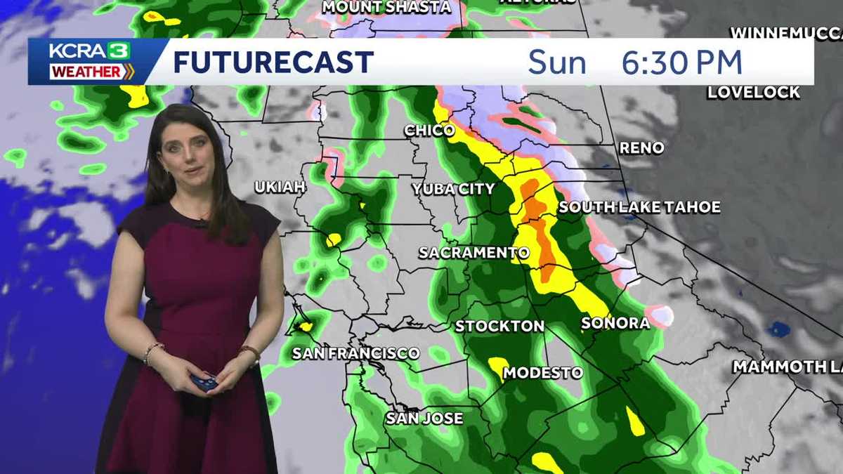
NOW LET’S SEND IT OVER NOW TO KELLY. TRACKING OUR FORECAST FOR TODAY. AND WE HOPE IT’S STAYING DRY. YEAH. YOU KNOW IF YOU WANT TO SQUEEZE IN A ROUND OF GOLF TODAY YOU’RE GOOD. GOOD TO GO. IT’S GOING TO BE CLOUDY BUT DRY. THIS IS A LIVE LOOK OUTSIDE IN SACRAMENTO WEST SACRAMENTO FROM THE SUTTER BALLPARK. AND YOU CAN SEE THAT WE DO HAVE AT LEAST A LITTLE BIT OF SUNSHINE THERE TRYING TO PEEK THROUGH THE CLOUDS. AGAIN, TODAY IS THE CALM BEFORE THE STORM. TEMPERATURES RIGHT NOW IN THE LOW 40S. BUT AS WE HEAD INTO THE AFTERNOON, MORE AND MORE CLOUD COVER WINDS OUT OF THE SOUTH, GENERALLY ABOUT 5 TO 10MPH, AND AFTERNOON HIGHS TODAY. WELL, THOSE ARE GOING TO BE IN THE LOW 60S, WHICH IS NORMAL FOR THIS TIME OF YEAR. SO WE’RE SUPPOSED TO SEE. ALL RIGHT. SO LIKE I SAID A LOT OF CLOUD COVER, ESPECIALLY UP BY YUBA CITY AND CHICO. YOU’RE STARTING TO SEE A FEW MORE BREAKS IN THOSE CLOUDS FOR SACRAMENTO STOCKTON AND AROUND THE DELTA. REDDING HAS SEEN A FEW LIGHT SHOWERS TODAY. SHASTA SEEING A LITTLE BIT MORE. LET’S TAKE A LOOK AT FUTURECAST. WE’RE GOING TO BREAK IT DOWN NOW. TODAY IS DRY. TODAY IS THE DAY TO RUN ERRANDS, GET EVERYTHING STOCKED UP, ALL THE SUPPLIES YOU NEED BECAUSE TRAVEL IS GOING TO BE DIFFICULT AS WE HEAD INTO THE WORKWEEK. NOW, AS WE GET INTO THIS EVENING, SAY YOU’RE GOING OUT TO DINNER, IT’S CERTAINLY GOING TO BE CLOUDY, BUT WE’RE NOT EXPECTING WET WEATHER. TONIGHT, THOUGH, THIS IS A LITTLE AFTER MIDNIGHT. YOU START SEEING A FEW SPOTTY LIGHT SHOWERS POPPING UP. AND THEN AS WE HEAD INTO TOMORROW MORNING, LOOK AT THIS. SHOWERS ALREADY MAKING THEIR WAY IN. WE’LL BE SEEING THEM AROUND DAVIS AND FAIRFIELD NAPA SOME MODERATE TO HEAVY SHOWERS, BUT NOTICE STILL DRY FOR THE SIERRA IN THE MORNING. SO IF YOU HAVE THINGS TO DO IN THE MORNING, YOU’RE STILL GOOD. BUT IF YOU’RE GOING TO BE UP THERE, MAYBE SKIING THINKING IT’S A LONG HOLIDAY WEEKEND, TRY TO GET DOWN EARLIER IN THE DAY ON SUNDAY AND DON’T WAIT UNTIL MONDAY BECAUSE MONDAY IS ROAD CONDITIONS ARE GOING TO BE PRETTY BAD. SNOW SHOWERS ARE GOING TO START AROUND 5:00 6:00 IN THE SIERRA. NOTICE A HEAVY RAIN THERE IN THE FOOTHILLS. SNOW LEVELS WILL BE PLUMMETING THIS WEEK AS WELL. AND AS WE GET INTO MONDAY, NOTICE ALL THAT MODERATE TO HEAVY RAIN IN THE VALLEY. STILL, THE CONTINUED SNOW SHOWERS THERE IN THE SIERRA. NOW RAINFALL TOTALS UP TO ABOUT AN INCH AND A HALF IN SACRAMENTO. THIS IS SUNDAY THROUGH WEDNESDAY, SO THAT’S NOT TOO DRAMATIC. SONORA COULD SEE UP TO THREE INCHES. SAME AROUND PLACERVILLE. IT’S THE SNOW. THAT’S THE BIGGER CONCERN HERE. AND THIS IS WHY IF YOU’RE IN, SAY IF YOU’RE UP THERE SKIING THIS WEEKEND, COME DOWN TOMORROW MIDDAY. I KNOW YOU’RE KIND OF MISSING A DAY, BUT LOOK AT WHAT WE’RE TALKING ABOUT ON MONDAY HERE. SNOW LEVELS STARTING OUT AROUND 5500FT, PLUMMETING DOWN TO 3200FT BY TUESDAY MORNING, AND THEN 2400FT ON WEDNESDAY. THAT’S PRETTY LOW. THAT MEANS POLLOCK PINES YOU ARE GOING TO SEE SNOW, IN FACT, UP TO A FOOT OF IT. BLUE CANYON COULD SEE UP TO THREE FEET OF SNOW. WE COULD EVEN SEE SNOW AROUND COLFAX. AT LEAST A LIGHT DUSTING. ANYWAY, DONNER SUMMIT COULD SEE UP TO FIVE FEET OF SNOW. SO TODAY IS THE DAY. LIKE I SAID, GET OUT THERE, RUN SOME ERRANDS, RAIN SHOWERS AND SNOW SHOWERS STARTING TOMORROW, BUT MONDAY AND TUESDAY ARE THE ALERT DAYS AND WEDNESDAY AN IMPACT DAY. LIKE I SAID, TRAVEL, ESPECIALLY IN THE SIERRA IS GOING TO BE INCREDIBLE. WE’RE TALKING ABOUT FEET. FEET OF SNOW. SO IF YOU CAN AVOID TRAVEL THOSE REALLY STRONGLY ADVISED WE’RE GOING TO HAVE CHAIN CONTROLS AND WILL LIKELY PROBABLY HAVE SOME CLOSURES ON 80 AND 50 AS WELL. ABSOLUTELY. MAYB
Northern California forecast: Calm before the storms
It’s a cloudy and dry Valentine’s Day, but you may want to run errands and stock up on supplies before a series of storm systems roll through the region bringing, rain, gusty winds, and heavy snow.

Updated: 8:50 AM PST Feb 14, 2026
**MONDAY and TUESDAY are ALERT DAYS. Wednesday is an IMPACT DAY.**Cloudy, dry, and seasonable Sunday with light south winds. Today is the day to prepare for the incoming storms. Rain will move into the area Sunday morning, but the main line of heavier showers arrives later in the day. Rain continues overnight and into Monday as winds increase. Rain will continue on and off through Wednesday. Rainfall amounts will not be excessive. Localized street flooding is possible, but creeks and streams should be fine. The NWS has issued a WIND ADVISORY for the Sacramento Valley from 10 am Monday to 10 pm Wednesday as South winds will gust 35-45 mph. Snow will be the most dramatic part of this system. It is expected to start Sunday afternoon and continue through Thursday. Several feet of snow are expected above 5,000′. Snow levels may even drop to 2,500′ by Wednesday. Chain controls are likely and closures are possible.
SACRAMENTO, Calif. —
**MONDAY and TUESDAY are ALERT DAYS. Wednesday is an IMPACT DAY.**
Cloudy, dry, and seasonable Sunday with light south winds. Today is the day to prepare for the incoming storms.
Rain will move into the area Sunday morning, but the main line of heavier showers arrives later in the day. Rain continues overnight and into Monday as winds increase. Rain will continue on and off through Wednesday. Rainfall amounts will not be excessive. Localized street flooding is possible, but creeks and streams should be fine.
The NWS has issued a WIND ADVISORY for the Sacramento Valley from 10 am Monday to 10 pm Wednesday as South winds will gust 35-45 mph.
Snow will be the most dramatic part of this system. It is expected to start Sunday afternoon and continue through Thursday. Several feet of snow are expected above 5,000′. Snow levels may even drop to 2,500′ by Wednesday. Chain controls are likely and closures are possible.