
Northern California forecast: Rain and snow on the way
A few scattered showers are already present Sunday morning, but the heavier rain is expected to arrive this afternoon and Sierra snow begins this evening.
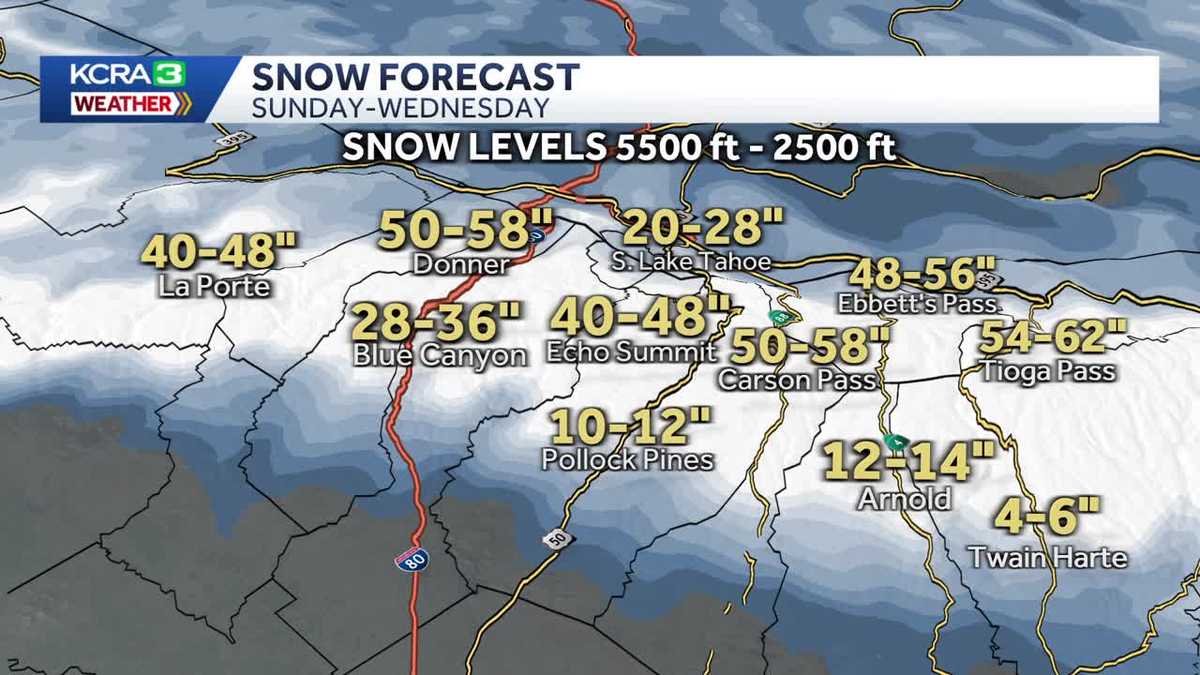
LET’S GET A CHECK OF OUR FORECAST FOR TODAY WITH KELLY. WE KNOW THAT RAIN IS MOVING IN. YEAH, THE RAIN IS ON THE WAY, BUT RIGHT NOW IN SACRAMENTO IT’S SUNNY. GO FOR A WALK. GO FOR A RUN. TEMPERATURES NOT AS COLD THIS MORNING EITHER BECAUSE WE HAVE THAT SOUTHERLY FLOW. AND WE’RE ALSO SAW AT LEAST SOME CLOUDS, AT LEAST FOR THE FIRST PART OF THE NIGHT. SO ENJOY THIS. RUN THOSE ERRANDS YOU NEED TO GET DONE BECAUSE THE RAIN IS COMING AND WE’RE ALREADY SEEING QUITE A BIT OF IT. CLOSER TO THE COAST, WE’VE SEEN SOME SHOWERS IN NAPA COUNTY, LAKE COUNTY. THOSE ARE CONTINUING TO TRACK THEIR WAY TO THE NORTH, AND THEN THE WHOLE SYSTEM IS SLIDING ITS WAY TO THE EAST. SO LET’S TAKE A LOOK AT FUTURECAST AND HOW EVERYTHING IS EXPECTED TO PLAY OUT. SO LIKE I SAID THIS MORNING, MOST OF THE SHOWERS A LITTLE BIT CLOSER TO THE COAST. I THINK THIS MODEL HAS THEM A LITTLE BIT TOO FAR EAST. BUT AS WE HEAD INTO THE EARLY AFTERNOON AND THEN MID AFTERNOON. SO THIS IS 330 NOTICE NOW WE’RE STARTING TO SEE SHOWERS AROUND STOCKTON MODESTO. SOME HEAVIER RAIN STARTING TO MOVE ITS WAY INTO SACRAMENTO, SEEING A LOT MORE ALONG THE COAST, ESPECIALLY AS YOU GET UP INTO THE COASTAL HILLS. THEN AS WE HEAD TOWARD 9:00, THIS IS SO EIGHT NINE. I’D SAY BETWEEN 7 AND 9. THAT’S WHERE WE’RE GOING TO START SEEING THE SNOW GOING IN THE SIERRA AND NOTICE THE HEAVIER BANDS OF RAIN IN THE VALLEY AND ALSO IN THE FOOTHILLS. WE’RE SEEING THOSE SHADES OF YELLOWS AND ORANGES. IT’S GOING TO BE PRETTY STEADY THROUGHOUT THE OVERNIGHT HOURS TONIGHT. SO BY THE TIME WE’RE WAKING UP MONDAY MORNING, WE’RE GOING TO BE DEALING WITH SLICK ROADS AND LIKELY CHAIN CONTROLS IN THE SIERRA. SOMETHING TO KEEP IN MIND. I KNOW MONDAY IS A HOLIDAY, SO A LOT OF PEOPLE DON’T HAVE TO WORK. THAT’S NICE. BUT IF YOU DROVE UP TO THE MOUNTAINS, HAVE A LONG WEEKEND, IT’S GOING TO BE REALLY DIFFICULT TO DRIVE HOME ON MONDAY. SO IF YOU CAN GO HOME TODAY, GO HOME LATER THIS AFTERNOON, GET SOME RUNS IN THIS MORNING AND THEN COME HOME BECAUSE THAT SNOW IS NOT GOING TO LET UP ALL DAY TOMORROW. NOW, MONDAY NIGHT WE GET A LITTLE BIT OF A BREAK. BUT LOOK AT THIS BY TUESDAY MORNING. HERE WE GO. MORE SNOW COMING DOWN, SCATTERED RAIN SHOWERS AGAIN. HEAVY AT TIMES. NOW LET’S TALK ABOUT HOW MUCH RAIN AND SNOW WE MIGHT SEE OUT OF THIS. SO IN SACRAMENTO WE’RE TALKING UP TO TWO INCHES OF RAIN. NOW THIS IS SUNDAY THROUGH WEDNESDAY RIGHT. SO FOUR DAY TOTAL PLACERVILLE COULD SEE UP TO ABOUT THREE INCHES STOCKTON ABOUT AN INCH AND A HALF. NOW, AS FAR AS THE SNOW GOES, IT’S GOING TO BE STARTING UP AROUND 25 OR 5500FT. THAT’S GOING TO BE FOR THE OVERNIGHT HOURS TONIGHT. AND THEN IT DROPS THROUGHOUT THE DAY ON MONDAY. BY TUESDAY, WE’RE AT 3200FT, AND BY WEDNESDAY, 20 400FT. LOOK AT THESE TOTALS. SO DONNER SUMMIT COULD SEE UP TO FIVE FEET OF SNOW AROUND TWO FEET UP BY SOUTH LAKE TAHOE. BLUE CANYON COULD SEE 2 TO 3FT OF SNOW AND EVEN POLLOCK PINES. YOU’RE UP AROUND 4000FT. YOU COULD SEE UP TO AROUND A FOOT OF SNOW OUT OF THIS SYSTEM. NOW WE ALSO HAVE A WIND ADVISORY. THIS IS FOR MONDAY THROUGH WEDNESDAY FOR THE SACRAMENTO VALLEY, FOR WINDS GUSTING UP TO 45MPH. SO YES, IT’S GOING TO BE COLD, WET AND WINDY IN THE FOOTHILLS AGAIN. RAIN SHOWERS START THIS AFTERNOON. THOSE ARE GOING TO CONTINUE ON AND OFF THROUGH THURSDAY. LOOK AT THOSE HIGHS TO ONLY 44 ON TUESDAY. THE SIERRA WE HAVE ALERT DAYS FOR MONDAY AND TUESDAY. AGAIN TRAVEL IS JUST NOT ADVISED. IT’S GOING TO BE A MESS. SO COME DOWN TODAY OR WAIT UNTIL THE STORM IS OVER. IF YOU’RE UP THERE SKIING NOW FOR THE VALLEY, WE’RE LOOKING AT SCATTERED RAIN SHOWERS TODAY, BUT THE HEAVIEST COMES TONIGHT THROUGH TUESDAY AND WEDNESDAY AND THURSDAY. WE’LL SEE SOME MORE SCATTERED SHOWERS, BUT BREEZY AND COLD TOO, BECAUSE TUESDAY’S HIGHS ONLY GOING TO BE 50. WOW. AND A LOT OF PEOPLE IT’S
Northern California forecast: Rain and snow on the way
A few scattered showers are already present Sunday morning, but the heavier rain is expected to arrive this afternoon and Sierra snow begins this evening.

Updated: 7:43 AM PST Feb 15, 2026
MONDAY and TUESDAY are ALERT DAYS. Wednesday is an IMPACT DAY. A few light rain showers are present from the coast into the Valley this morning, and there were a few light snow showers in the Sierra overnight. The morning will be fairly quiet with just scattered, mainly light, rain showers… but rain will increase in intensity and become more widespread by early afternoon. The heavier snow looks like it will arrive in the Sierra after sunset… giving skiers a little extra time to leave the mountain and head home… but anyone that waits until the holiday on Monday will be in for a very unpleasant drive or end up stuck if the roads close. The WINTER STORM WARNING for the Sierra and Coastal Hills begins 10:00 pm Sunday and continues through 10:00 pm Wednesday. Widespread rain and mountain snow (levels around 5,000′) continue through the overnight and into Monday. Monday morning’s commute will be slick and chain controls are expected in the Sierra. Winds also increase on Monday. A WIND AVISORY is set to begin at 10:00 am Monday and continue until 10:00 pm Wednesday for the Sacramento Valley as winds may gust up to 45 mph. We’ll get a little break Monday night with more rain and Sierra snow returning for Tuesday, but with lower snow levels, around 3,000′.While rain and snow will become more scattered and will not be as intense on Wednesday…. snow levels are forecast to fall to 2,400′. Lingering showers are forecast for Thursday… then dry conditions Friday into the weekend. Another storm system may be on the way next week.
SACRAMENTO, Calif. —
MONDAY and TUESDAY are ALERT DAYS. Wednesday is an IMPACT DAY.
A few light rain showers are present from the coast into the Valley this morning, and there were a few light snow showers in the Sierra overnight. The morning will be fairly quiet with just scattered, mainly light, rain showers… but rain will increase in intensity and become more widespread by early afternoon. The heavier snow looks like it will arrive in the Sierra after sunset… giving skiers a little extra time to leave the mountain and head home… but anyone that waits until the holiday on Monday will be in for a very unpleasant drive or end up stuck if the roads close.
The WINTER STORM WARNING for the Sierra and Coastal Hills begins 10:00 pm Sunday and continues through 10:00 pm Wednesday.
Widespread rain and mountain snow (levels around 5,000′) continue through the overnight and into Monday. Monday morning’s commute will be slick and chain controls are expected in the Sierra. Winds also increase on Monday. A WIND AVISORY is set to begin at 10:00 am Monday and continue until 10:00 pm Wednesday for the Sacramento Valley as winds may gust up to 45 mph.
We’ll get a little break Monday night with more rain and Sierra snow returning for Tuesday, but with lower snow levels, around 3,000′.
While rain and snow will become more scattered and will not be as intense on Wednesday…. snow levels are forecast to fall to 2,400′.
Lingering showers are forecast for Thursday… then dry conditions Friday into the weekend. Another storm system may be on the way next week.