


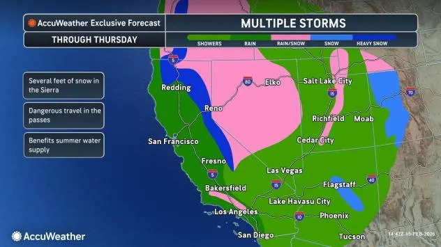
Storm train targets California with flooding rain and pass closures
As a deep plume of moisture makes its way inland across the West Coast, a multitude of hazards could arise this week, ranging from localized flooding and severe thunderstorms to feet of snow in the mountains and gusty winds.
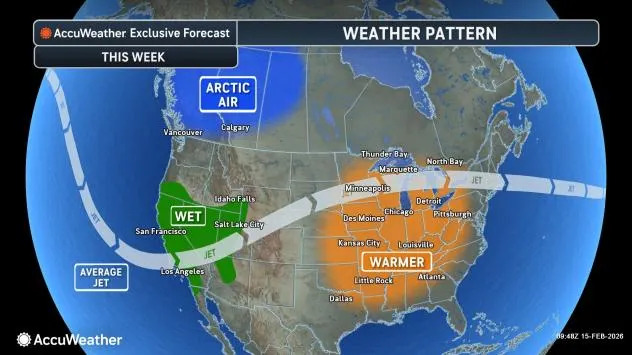
Potent storms return to the Golden State
After weeks dominated by weather that was dry and warmer than the historical average, the transition to a stormier pattern will mark a clear change of pace for the region. Water levels statewide are running at about half of their typical mid-February levels. While the incoming storms may create hazards, they will also offer much-needed moisture.
AccuWeather.com
“It will be a wet week across California as a series of storm systems slam into the state. Multiple inches of rain will fall across much of the state, with several feet of snow expected in the Sierra,” explained AccuWeather Meteorologist Kai Kerkow.
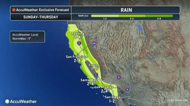
Soaking rain from the coast to valley locations
This week, forecasters say that three separate storms are set to track into the western states. The rain field associated with the first storm began to move onshore on Sunday while the core of the storm’s energy will shift inland on Monday.
The second storm will dive south and east from the Pacific Northwest into California Monday night into Tuesday night, ushering in another wave of soaking rain. By late week, a third and final storm of the week is expected on Thursday, which is anticipated to focus along the Central Coast and portions of Southern California.
AccuWeather.com
Cumulative rainfall amounts will be 1-2 inches across Southern California and the Central Valley, increasing to 2-4 inches along the central coast and into Northern California. Orographic enhancement could push localized amounts beyond 4 inches in the Sierra Nevada and adjacent higher terrain.
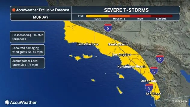
Monday: severe thunderstorm risk
In addition to the deluge of moisture this week, forecasters are also warning of the risk for robust thunderstorms in northern portions of the Central Valley as well as coastal Southern California.
As the first in a series of storms moves into California on Monday, thunderstorms are expected to develop across the Los Angeles Basin. These storms may trigger flash flooding, especially in urban areas and near burn scars, along with gusty winds and even an isolated tornado.
AccuWeather.com
While severe weather is not expected to be widespread, the risk zone includes densely populated areas from San Luis Obispo County south through San Diego County. Any storm that intensifies could produce damaging wind gusts, frequent lightning and downpours, so residents should stay alert for rapidly changing conditions.
Forecasters also note that there could be rumbles of thunder as rain shifts across Central California with a separate risk for spin-ups around the Sacramento Valley.
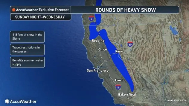
Cold air arrives this week, dropping snow levels
As the jet stream takes a nosedive along the West Coast, it will help to usher in cooler conditions that will allow for any moisture that spreads into the higher terrain to fall as snow-and in notable amounts at that.
“An abundance of cold air will result in snow levels dropping down to 4000 feet by Wednesday. This weeks’ pattern will bring significant travel impacts to the passes, including I-80 over Donner Pass,” explained Kerkow.
AccuWeather.com
From Sunday night to Thursday, between 3-4 feet of snow is expected with the heaviest period likely to be from Monday night through Tuesday. While snowfall totals on the order of feet will be disruptive for the region, there may be long-term benefits that come out of it.
“The state’s snowpack is running well below average for this time of year due to a dry and warm weather pattern that lasted from the middle of January through the beginning of February, so the active weather pattern will be beneficial for the summer water supply,” added Kerkow.
However, this active weather could also close several passes.
“All passes across the Sierra could be closed at some point in time from Monday to Wednesday. Donner Pass could be closed on multiple occasions,” stated AccuWeather Senior Meteorologist Adam Douty.
AccuWeather.com
Late week: will snow reach the Southern CA mountains?
As the final storm of the week moves into Southern California on Thursday, another round of rain is expected to sweep across the Los Angeles Basin. However, this system will arrive with colder air, allowing snow levels to drop to around 3,000-4,000 feet.
That means accumulating snow in California will not be limited to the Sierra Nevada. Snow could also fall across the higher terrain surrounding the basin, including the Tehachapi Mountains near the Grapevine along Interstate 5 as well as the San Gabriel and San Bernardino mountains.
Travel through the Grapevine corridor could potentially become slick if snow develops, and motorists heading into the San Gabriel and San Bernardino ranges may encounter winter driving conditions.
Want next-level safety, ad-free? Unlock advanced, hyperlocal severe weather alerts when you subscribe to Premium+ on the AccuWeather app. AccuWeather Alerts™ are prompted by our expert meteorologists who monitor and analyze dangerous weather risks 24/7 to keep you and your family safer.