
California is in the cross-hairs of back-to-back storms that are predicted to bring flooding rain, heavy snow, damaging wind, dangerous surf and even a chance of tornadoes to parts of the state. Nearly every inch of California is forecast to receive precipitation this week, with more areas than usual seeing snow rather than just rain.
The first storm will begin Sunday in Northern California and along the Central Coast, with moderate to heavy rain showers, while Southern California sees overcast skies and a few sprinkles. By Sunday night, steady snow should move into the Sierra Nevada. Downpours are predicted to hit Southern California on Monday.
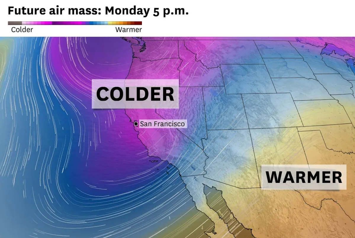
A short break between systems Monday night will be quickly followed by a colder storm Tuesday into Wednesday. That one will bring California its coldest air in three years, raising the potential for snow in the Sierra foothills, parts of the Bay Area and the Interstate 5 Grapevine.
Another system is expected to hit Thursday, but here’s what to expect from the first two storms set to hit the Golden State:
Bay Area
Sunday will become progressive wetter throughout the day. Morning showers will target Marin, Sonoma, San Francisco and San Mateo counties, but raindrops cannot be ruled out elsewhere.
By noon, steady rain should reach San Francisco and Oakland before spreading east through the afternoon and evening. Downpours are most likely from 4 to 10 p.m.
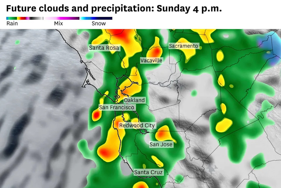
Moderate to heavy rain showers are expected across the Bay Area on Sunday afternoon. (Baron/Lynx)
Rain chances exist all across the Bay Area on Monday, but the Santa Cruz Mountains, South Bay and East Bay are expected to be under the heaviest swath, totaling between 1 and 3 inches. A slight change in the system’s position could move the band of showers farther north toward San Francisco. Minor flooding of roadways and small creeks and streams is possible.
Wind direction and speed will fluctuate Sunday and Monday as a low-pressure system passes to the south. In San Francisco, winds Sunday will gradually shift from southeast to southwest. On Monday, they’ll start out of the northeast before turning out of the northwest in the late afternoon. Gusts could exceed 40 mph Monday evening.
A cold front Tuesday will bring a renewed chance of precipitation and strengthening winds as it moves north to south. Any showers that linger overnight could fall as snow above 2,500 feet.
Sierra Nevada
A long-lasting winter storm warning is in effect from 10 p.m. Sunday to 10 p.m. Wednesday across the entire Sierra. Ski resorts along the crest could pick up 5 to 7 feet of snow.
It appears there will be two waves of heavy snow during the focal period.
The first burst comes Monday morning through evening, with snowfall rates peaking at 1 to 2 inches per hour. The snow line will start around 6,000 feet before dropping to 5,000 feet.
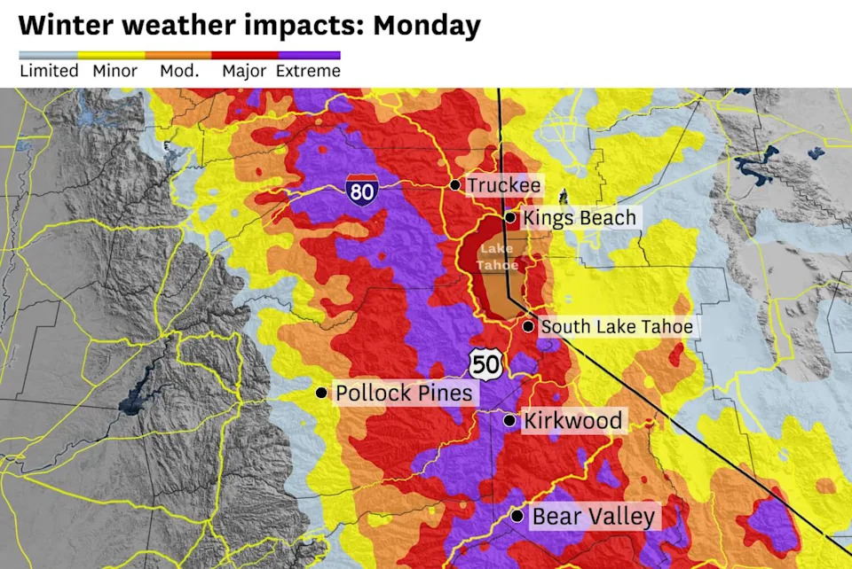
The National Weather Service warns of major to extreme travel impacts in the Sierra Nevada on Presidents Day. (Baron/Lynx)
In the Tahoe area, “snowfall rates will diminish late Monday night into Tuesday morning, then increase again as the stronger, colder wave moves through from Tuesday afternoon into Wednesday morning,” the National Weather Service said.
That cold second pulse could increase snowfall rates up to 3 inches per hour between Interstate 80 and Yosemite National Park. Blowing snow will become a hazard as wind gusts reach up to 50 mph in Sierra communities and up to 100 mph atop ridges. It’ll also drag the rain-snow line below 2,500 feet Wednesday morning.
The cold air will support light, fluffy snow that skiers prefer, but the powder can blow around and drop visibility to near zero at times. Typically, 10 inches of snow melts to 1 inch of rain, but the cold air Tuesday night through Wednesday could increase ratios to 15:1.
Central and Southern Coast
Monterey to San Diego appears to be in the bull’s-eye of Monday’s system.
A squall line will move west to east throughout the day, bringing numerous hazards with it.
The heaviest downpours are expected to drop an inch of rain in an hour and cause flash flooding. Damaging wind gusts could knock down branches and power lines. Waterspouts and a brief tornado also are possible, though the risk is low.
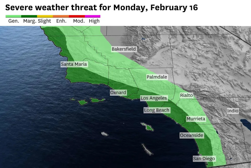
A marginal (level 1 out of 5) risk of severe thunderstorms, including tornadoes, is forecast along the Central and Southern California coast Monday. (Baron/Lynx)
A lull Tuesday will be followed by a cold front that evening. It’ll bring snow down to 3,500 or lower by early Wednesday, making for a huge dumping in the mountains, including Big Bear.
Elsewhere
• Accumulating snow is forecast along I-5 passes in Northern and Southern California. More than a foot is forecast at Black Butte Summit (Siskiyou County) near Mount Shasta on Tuesday, with a few inches along the Grapevine early Wednesday.
• Hazardous seas are expected all week. High surf is forecast to peak Tuesday and Wednesday, with breaking waves up to 15 feet on the North Coast, up to 20 feet along the Central Coast and 10 to 15 feet along the South Coast.
This article originally published at California storms are about to hit. Here’s a timeline of their most severe impacts.