
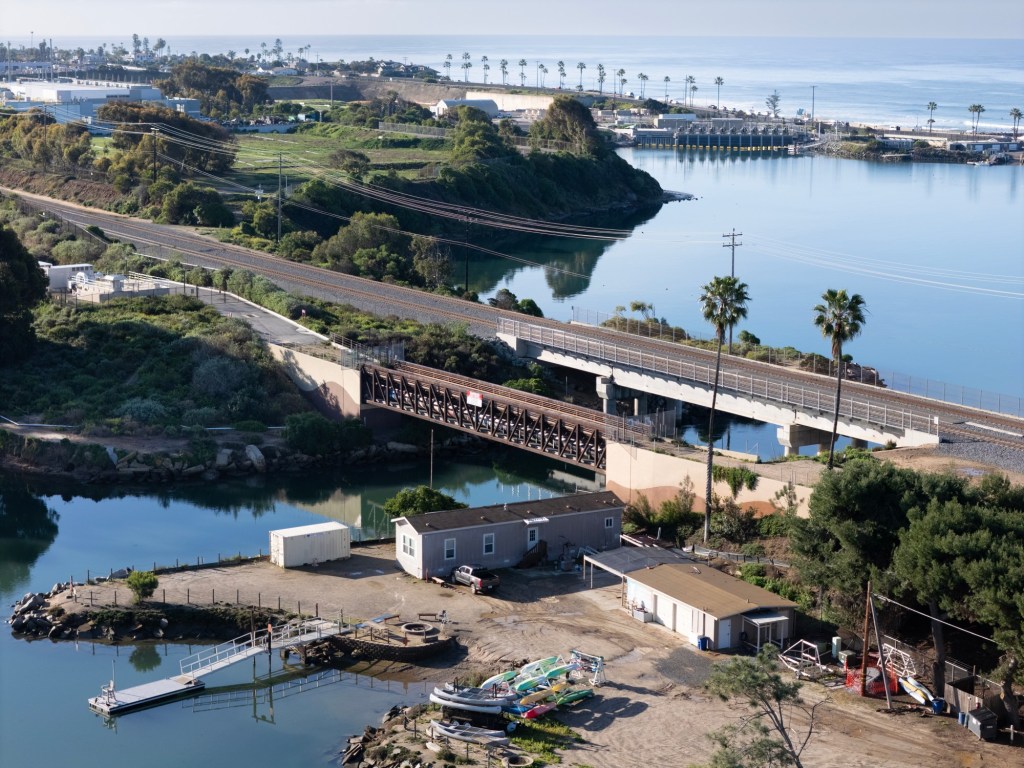
A pedestrian bridge built 10 years ago across the Agua Hedionda Lagoon in Carlsbad remains closed to the public in an unfinished segment of the 42-mile Coastal Rail Trail that, when completed, will go between Oceanside and downtown San Diego.
“There are many public and private property owners who need to agree on the creation of this segment,” said Pete Penseyres, a Carlsbad resident, in an email Thursday.
“Any one of them can say ‘no’ and stop the project,” said Penseyres, an avid cyclist, a cycling instructor, and a member of the city’s Traffic Safety and Mobility Commission.
“Cyclists now use Carlsbad Boulevard for this segment and will likely continue to do that, especially for recreational purposes, due to the open view of the ocean on one side and the lagoon on the other,” he said.
If the segment is ever completed, he said, “I think it would be more useful for bike commuters, families on bikes or other wheeled devices, and especially for pedestrians, including runners.”
The narrow bridge was installed just east of a double-tracked railroad bridge. Its primary purpose was to carry water and sewer utility lines across the lagoon’s main channel, but it also was intended to be part of the popular bicycle and pedestrian trail planned along the tracks.
“Connectivity to the Coastal Rail Trail was considered during planning, but (the city) did not move forward because of concerns with the trail traversing nearby private property,” Carlsbad officials said in a written response to questions.
Maintenance trucks use the single-lane bridge, which can support vehicles weighing up to 20,000 pounds, officials said. Beneath the deck, or roadway surface, the structure carries sewer, water and recycled water pipelines and conduits for electrical and fiber optic cables.
The 140-foot-long pedestrian bridge was built about 2016 as part of a two-year, $64.2 million sewer project shared by Carlsbad and Vista that included the replacement of a key pump station and a 2-mile main pipeline through Carlsbad to the Encinas treatment plant.
The pump station on the southern edge of the lagoon was needed to push the effluent coming from the two cities uphill through a pressurized line called a “force main” to a point south of Cannon Road in Carlsbad, where gravity carries it the rest of the way downhill to the Encinas plant.
The bridge replaced two old wooden trestles that carried only utility lines and no vehicles or pedestrians. It also was intended to be part of the yet-to-be completed segment of the rail trail between Tamarack Avenue and Cannon Road.
Known as segment 7G, the missing piece of trail that includes the bridge covers 1.2 miles between Tamarack Avenue and Cannon Road.
“A cost estimate has not yet been developed for this segment and no funding is currently available,” according to the city’s statement.
“A conceptual design still needs to be developed … to move the project forward through phases including public input, final design, permitting and construction,” it states.
“Improvements would be needed in order to incorporate the existing pedestrian bridge into the trail, including enhanced connectivity to the north and south ends of the bridge, as well as maintenance to the bridge itself,” city officials said in their response.
Carlsbad has completed other pieces of its share of the trail. The city has a stand-alone, separate-from-streets piece along the eastern side of the tracks between Tamarack and Oak avenues, with easy access to the downtown Village and Barrio neighborhoods.
Construction is expected to start later this year on an additional one-mile segment between Palomar Airport Road and the Poinsettia Coaster Station in Carlsbad.
Longer-term plans call for the trail to continue south on Encinas Avenue until it links up with Carlsbad Boulevard, also known as Coast Highway 101, where it will connect with the trail in Encinitas.
The Coastal Rail Trail idea emerged in the 1990s as a plan for a 42-mile walking and biking pathway along the railroad tracks between the Oceanside Transit Center and the Santa Fe Depot in downtown San Diego.
Since then, each city along the route has completed portions of the trail. However, challenges such as the creeks and coastal lagoons have slowed progress and required some segments to be routed away from the rails and onto nearby surface streets.
Oceanside completed a stand-alone section of the trail along the tracks between Oceanside Boulevard and Wisconsin Avenue in 2014.
Construction will start this year on Oceanside’s final piece of the trail, a half-mile segment from Oceanside Boulevard south through Buccaneer Park to a connection at South Myers Street. The project includes the installation of a prefabricated pedestrian bridge beside the railroad bridge across Loma Alta Creek in the park.
Solana Beach completed a 1.7-mile, meandering section of the trail lined with landscaping, sculptures and creative archways about 20 years ago.
The Solana Beach City Council recently received a $300,000 state grant for the construction of a final piece in that city that will extend the trail from Ocean Street north to the southern boundary of Encinitas. The total cost there is a little more than $1 million. Construction is expected in 2027.
Encinitas has a 1.3-mile segment of the trail from Chesterfield Drive to Santa Fe Drive that opened to the public in 2019. Additional pieces in Encinitas also are planned.
Most of the rail trail completed so far has been in North County. Construction is scheduled to start in 2027 on a nearly 2-mile segment along Gilman Drive between La Jolla Colony Drive and La Jolla Village Drive in La Jolla, according to a San Diego list of capital improvement projects.