
The coldest storm of the season is bringing periods of heavy rain, thunderstorms and gusty winds. Snow level will come crashing down to near 1000 feet by Wednesday.
SACRAMENTO, Calif. — Weather conditions forecast for the Sacramento region through Wednesday will be very active with periods of low visibility, heavy rain, gusty winds and lowering snow levels.
This is a highly disruptive storm, especially in the high country.
We’re talking about 2 to 3 inches of valley rain and 4 to 8 feet of Sierra snow at the high passes through Wednesday. Snow levels on Tuesday and Wednesday will be as low as 1,000 feet. Up to a foot of snow is possible as low as 2,500 ft through midweek.

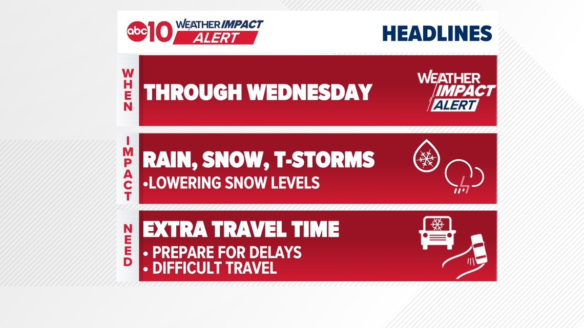
When
Widespread heavy rain and heavy snow are expected Monday through Wednesday.
The heaviest rain will hit the valley Monday and Tuesday with the highest accumulations.
Snow levels will go from about 5,000 ft on Monday, then 3,000 ft on Tuesday and as low as 1,000 ft Wednesday morning.
► Stay up to date with the forecast and weather impact team with the ABC10+ streaming app. Here’s how to download it for free.
Impact
A very impactful system that’ll bring at least a couple of inches of rain to the valley and several feet of snow to the Sierra. Very low snow levels and gusty winds are expected.
The valley is seeing ongoing moderate rain resulting in some minor flooding. This is especially true in low lying places and ponding on roads. Storm drains are also getting clogged. A Flood Advisory is in effect through 4 p.m. Monday.
A Winter Storm Warning is in effect through 10 p.m. Wednesday.
Weather models are in very good agreement on how much snow to expect. At the high passes of I-80 and Highway 50, 4-8 ft of snow is likely, with the ski resorts coming in closer to 8 ft. Snow will be winding down on Thursday. Sierra wind gusts could be as high as 55 mph, leading to whiteout conditions.
Weather models are also in good agreement about very low snow levels down to near 1,000 ft by early Wednesday. Accumulation elevations will start closer to 2,000 ft.
1 foot of snow expected between 2,000 ft and 2,500 ft1 to 2 feet of snow expected between 2,500 ft and 3,500 ft4 to 8 feet of snow expected above 3,500 ft, with the highest amounts at and above the high passes
Snow levels will go from about 5,000 ft on Monday, then 3,000 ft on Tuesday and as low as 2,000 ft Wednesday morning.
Valley rain is likely to be between 2.0″ and 3.5″, also with good model agreement. Widespread flooding is not expected, but some local impacts – especially in urban areas – are possible. Low-lying areas and small creeks and streams may experience minor flooding.
A Wind Advisory is in effect for the Sacramento Valley until 10 p.m. Wednesday.
The valley could see 35-45 mph wind gusts through midweek.
Weather Impact Resources
► FORECAST DETAILS | Check out our hourly forecast and radar pages
► GET WEATHER ALERTS TO YOUR PHONE | Download the free ABC10 mobile app ► GO DEEPER | Stream in-depth weather forecasts and investigative reports with the free ABC10+ streaming app
► WEATHER IN YOUR EMAIL | Sign up for our daily newsletter
► MEET THE WEATHER IMPACT TEAM | Chief Meteorologist Monica Woods, Brenden Mincheff, Rob Carlmark
Need
Don’t let the quiet and mild weather catch you off guard! Be ready for impactful weather through midweek.
Heavy snow and strong winds will make travel in the Sierra very difficult without a break through at least Wednesday.
Travel will be exceptionally impacted and may be downright impossible at times. Road closures have already been occurring due to spinouts.
In the valley, conditions will be very wet and soggy through at least Wednesday. Make sure you have the rain gear ready. Outdoor plans should be reconsidered.
ABC10: Watch, Download, Read
For more ABC10 news and weather coverage on your time, stream ABC10+ on your TV for free:
► Roku – click here
► Amazon Fire – click here
► Apple TV – click here
GO DEEPER: The ABC10 Weather Impact Team investigates algae and bacterial threats to some of California’s largest natural lakes.