

A powerful storm is poised to move across California on Monday. This will be a “lead” system as the door will be wide open for more in the days to come.
WIND, RAIN & MOUNTAIN SNOW MONDAY
Strong south flow ahead of the offshore low will lead to a familiar sight: south/southeast winds intensifying from the mountains, down into and through the South Valley. Wind Advisories have been issued from the South Valley (from 7 AM until 7 PM Monday) to the Desert (from 7 AM Monday until 4 PM Wednesday). These winds could top out at 35 to 60 mph. With this type of setup if would not be out of the question to get wind speeds even higher than that (especially over the ridgetops), so be advised and prepared for possible tree damage and power outages.
RELATED: Winter storms line up for California during President’s Day week
Rain will work into the area from the south and west during the day. All areas should get wet, but as we know, the South Valley is susceptible to a “rain-shadow” effect, which means the overall rainfall intensities and totals could be lower compared to other parts of the area and surrounding regions, especially during the initial system on Monday.
Temperatures could get rather mild initially, with 60s in the Valley, as the downsloping wind will work to warm the air up. As the cold front sweeps through, the temperatures should start to drop with the 40s kicking into the desert during the afternoon. That combined with the winds (and rain at times) will make it feel even colder, so be prepared with those jackets, coats, and maybe even gloves on hand!
As for the snow: right now it looks like the snow levels may fall to around 5,000 feet Monday afternoon/evening. This puts it safely above the passes for now, but even that will change.
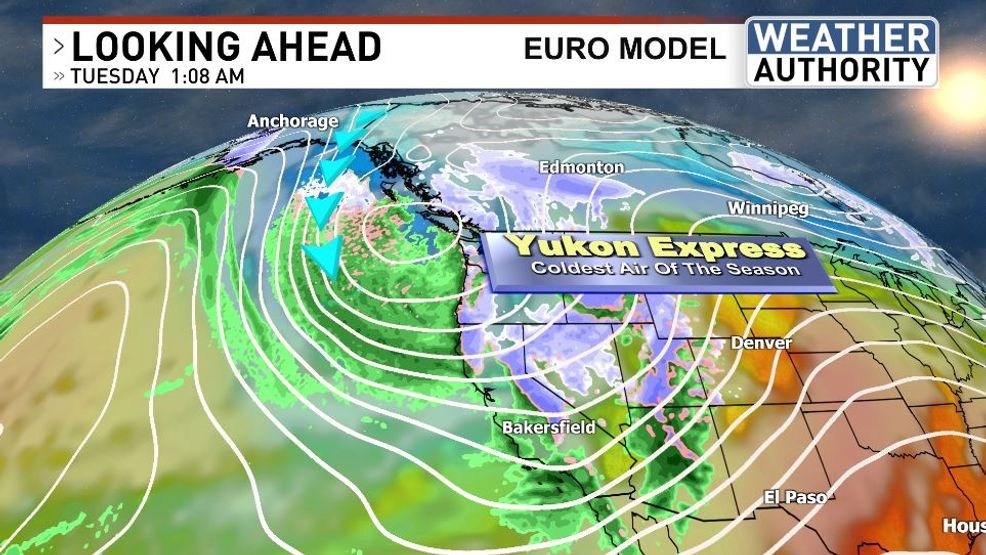
COLDER SYSTEM(S) FOR LOWER SNOW LEVELS TUESDAY-WEDNESDAY
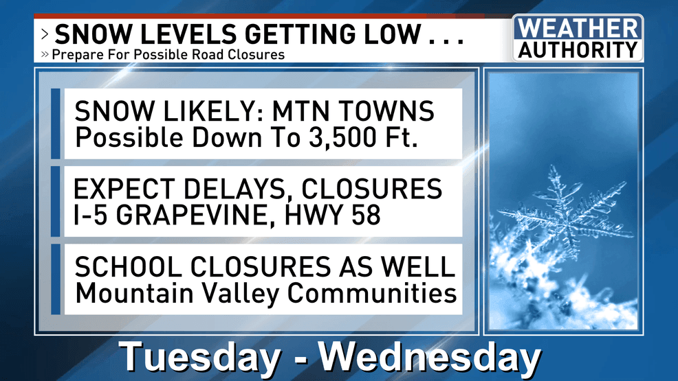
Following the Monday storm, a deep and cold trough, with air trajectories coming straight out of the Yukon and Alaska, is forecast to surge southward. Even colder air comes in with this second system diving out of the north Tuesday and that is when snow could go down to the 4,000-foot level (probably Tuesday evening/night). Another system digs in and sends an even colder airmass our way by Wednesday and that could drop snow levels even lower. Tuesday night to Wednesday is when we will be looking at the highest chance of major road slowdowns or even closures (like the Interstate 5 through the Grapevine – Lebec/Gorman corridor and the Tehachapi Pass of Highway 58).
A powerful storm is poised to move across California on Monday, Feb. 26, 2026. (KBAK/KBFX)
Snow, and plenty of it, is likely across all of our mountain towns, with the potential of impassable roads and school closures too. A Winter Storm Warning is in effect until 10 PM Wednesday for the Frazier Mountain communities, Piute Walker Basin and Tehachapi. A Winter Storm Watch has been issued for the Grapevine-Lebec corridor of the I-5 from Monday afternoon through Thursday morning for snow levels falling below the Tejon Pass on Tuesday.
Lastly, there are signs of yet another system zipping through on Thursday, which could move through the already cold air in place (by that time), which may potentially add to the wintry setup but it’s still speculative at this point.
The bottom line: please keep checking back in for the very latest and prepare for the potential of road closures this week, which could affect your daily commute – if you have one.
A powerful storm is poised to move across California on Monday, Feb. 26, 2026. (KBAK/KBFX)
-Chief Meteorologist Ilya Neyman