
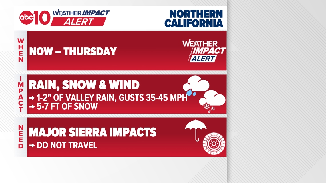
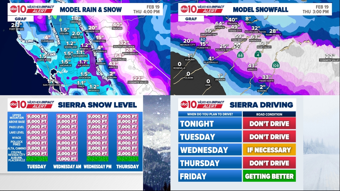
Up to 2″ more valley rain and 5–7 feet of Sierra snow expected. Snow levels are expected to drop below 1,000 feet on Wednesday.
SACRAMENTO, Calif. — Weather conditions forecast for the Sacramento region remain cold and wet, with heavy snow in the high country.
The coldest storm of the season is moving through Northern California right now. It’s already brought about 1.75″ of rain to the valley and another 1-2″ is expected before the storm is over.
The biggest impacts are in the Sierra. Between today and Thursday, another 5-7 ft of snow is likely at the high passes! However, this cold storm means very low snowfall.
Tuesday morning snow levels will be about 2500 ft, falling to 750 ft – that’s not a typo, 750 ft – on Wednesday morning! Snow levels will remain between about 1000 and 2000 ft on Thursday.
A dusting to an inch or two of snow is possible in Auburn, Jackson, Placerville, and Sonora. Low-elevation communities that typically don’t see snow.

When
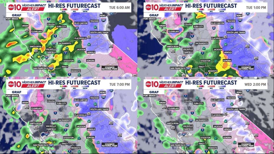
Heavy snow continues on Tuesday in the Sierra.
Heavier rain is expected to return to the valley on Tuesday morning. Some thunderstorms are also possible. Tuesday is largely more of the same at all elevations.
A brief lull in the storm on Wednesday morning with less rain and scattered moderate Sierra snow showers. However, snow will resume on Wednesday evening ahead of another push of moisture on Thursday morning.
Heavy valley rain and heavy Sierra snow for most of Thursday before the system finally starts to wind down by that evening.
The strongest winds will be on Thursday as the center of the system moves across Northern California. Wind gusts will be out of the southwest at about 45 mph.
► Stay up to date with the forecast and weather impact team with the ABC10+ streaming app. Here’s how to download it for free.

Impact
Sierra roads will continue to deteriorate. Interstate 80 and Highway 50 were closed more than once on Monday due to traffic spinouts and crashes over the crest. Tuesday will not be better. Do not travel. There’s no getting over the Sierra. Full stop. This is the real deal storm and there’s nothing to do except wait it out.
Rain will cause localized flooding issues in the valley. In other words, widespread flooding is not forecast, but flooding on some roads, in urban areas, and in small creeks and streams is possible.
Wind gusts on Tuesday will reach up to about 30 mph and may be somewhat of a nuisance. The strongest winds on Thursday could exceed 45 mph and knock over or blow around loose objects outside. In some cases, it could lead to a power outage.
Weather Impact Resources
► FORECAST DETAILS | Check out our hourly forecast and radar pages
► GET WEATHER ALERTS TO YOUR PHONE | Download the free ABC10 mobile app ► GO DEEPER | Stream in-depth weather forecasts and investigative reports with the free ABC10+ streaming app
► WEATHER IN YOUR EMAIL | Sign up for our daily newsletter
► MEET THE WEATHER IMPACT TEAM | Chief Meteorologist Monica Woods, Brenden Mincheff, Rob Carlmark
Need
Avoid travel in Sierra until the storm passes. There won’t be a good time to travel.
In the valley, avoid flooded roads if they occur. Mainly, this is about giving yourself extra time to get where you’re going due to the rain and bringing the rain jacket and/or umbrella with you.
Bring in loose outdoor objects by Thursday, before the strongest winds arrive.
ABC10: Watch, Download, Read
For more ABC10 news and weather coverage on your time, stream ABC10+ on your TV for free:
► Roku – click here
► Amazon Fire – click here
► Apple TV – click here
GO DEEPER: The ABC10 Weather Impact Team investigates algae and bacterial threats to some of California’s largest natural lakes.