
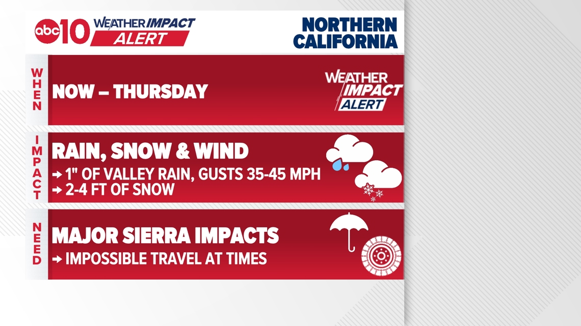
Cold, wet weather continues with heavy rain and Sierra snow through Thursday. Snow levels could drop below 1,000 feet before drier conditions Friday.
SACRAMENTO, Calif. — Weather conditions forecast for the Sacramento region remain cold and wet.
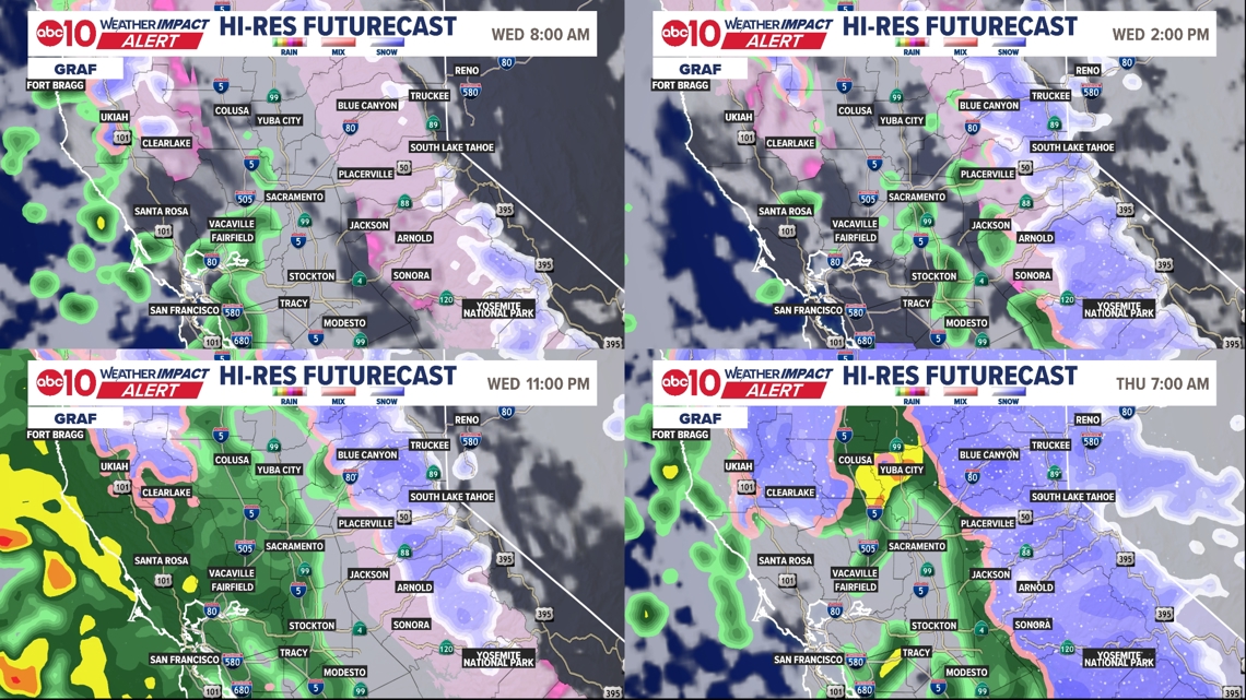
Wednesday will see more scattered rain in the valley, and although snow will briefly pause early on Wednesday morning, heavier stuff returns by lunchtime.
One final push of moisture comes in late Wednesday evening and continues through Thursday.
This will be the coldest part of the storm, with heavy rain, heavy snow, and very low snow levels below 1000 ft. A dusting down towards 750 ft is possible.
Continue to avoid Sierra travel. Chain controls will remain through the duration of this storm. Better driving returns on Friday.

When
We’ll likely see a quieter weather period on Wednesday morning. Mostly dry in the valley with scattered Sierra snow.
Very low snow levels under 1000ft are likely, though there may not be much snow during this period. But more is on the way.
We’ll see on-and-off rain in the valley on Wednesday, with snow picking up again by lunchtime.
A stronger, final push of moisture arrives late Wednesday evening and continues through Thursday. This will be the coldest part of the storm.
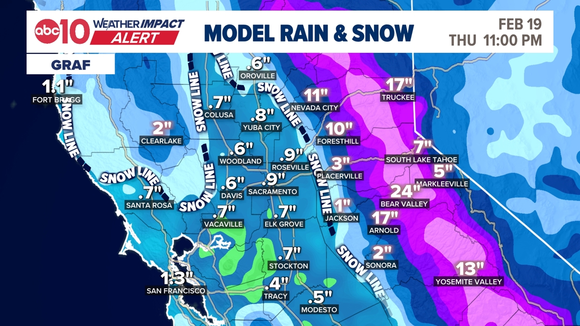
Snow levels drop back towards and below 1000 ft on Thursday morning. Some high-resolution weather models have been extremely aggressive in forecasting ultra-low-level snow potential for Thursday morning.
It’s very unlikely to get even a dusting of snow below 500 ft in elevation; however, some mixed precip – rain with a few flurries – isn’t entirely out of the question below 500 ft. Nothing would stick.
Heavy valley rain and heavy Sierra snow for most of Thursday before the system finally starts to wind down by that evening
► Stay up to date with the forecast and weather impact team with the ABC10+ streaming app. Here’s how to download it for free.
Impact
Sierra roads will continue to be greatly impacted. Interstate 80 and Highway 50 were closed for most of Tuesday due to heavy snowfall. Wednesday will continue to see very difficult to impossible driving conditions. Do not travel. There’s no getting over the Sierra. Full stop. This is the real deal storm and there’s nothing to do except wait it out.
Some high-resolution weather models have been extremely aggressive in forecasting ultra-low-level snow potential for Thursday morning.
It’s very unlikely to get even a dusting of snow below 500 ft in elevation; however, some mixed precip – rain with a few flurries – isn’t entirely out of the question below 500 ft. Nothing would stick.
Rain will cause localized flooding issues in the valley. In other words, widespread flooding is not forecast, but flooding on some roads, in urban areas, and in small creeks and streams is possible.

Weather Impact Resources
► FORECAST DETAILS | Check out our hourly forecast and radar pages
► GET WEATHER ALERTS TO YOUR PHONE | Download the free ABC10 mobile app ► GO DEEPER | Stream in-depth weather forecasts and investigative reports with the free ABC10+ streaming app
► WEATHER IN YOUR EMAIL | Sign up for our daily newsletter
► MEET THE WEATHER IMPACT TEAM | Chief Meteorologist Monica Woods, Brenden Mincheff, Rob Carlmark
Need
Continue to avoid travel in Sierra until the storm passes. There won’t be a good time to travel until Friday, when the snow has stopped.
In the valley, avoid flooded roads if they occur. Mainly, this is about allowing extra time to get where you’re going due to the rain, and bringing a rain jacket and/or umbrella.
ABC10: Watch, Download, Read
For more ABC10 news and weather coverage on your time, stream ABC10+ on your TV for free:
► Roku – click here
► Amazon Fire – click here
► Apple TV – click here
GO DEEPER: The ABC10 Weather Impact Team investigates algae and bacterial threats to some of California’s largest natural lakes.