

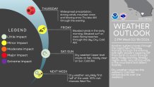
The third and final round of this week’s winter weather will move through on Thursday, bringing more rain, wind, and possible mountain snow.
This round may not have as much moisture, but it will be colder, NBC 7’s meteorologist Greg Bledsoe said. Light to moderate rain will move in on Thursday afternoon. Rain totals will range from about a quarter to a half inch for the coast and valleys, and then about a half inch to an inch for the foothills and mountains.
Winds are expected to pick up again as a wind advisory goes into effect at 9 a.m. Thursday for the coast and valleys. The advisory will remain in effect until 2 a.m. Friday.
“Light to moderate rain is expected on Thursday—ponding of water on roads and minor street flooding in urban areas possible. Thunderstorms may bring locally heavy rain, stronger winds, and small hail,” weather officials said.
There is a slight chance of thunderstorms, mainly in the coastal areas and western valleys, that could produce very gusty, erratic winds and brief heavy rain that could lead to some flooding, the National Weather Service said.
Expect snow as low as 4,500 ft in elevation, and expect 1 to 8 inches from that elevation up to 7,000 feet, with 8 to 12 inches on the highest peak, the NWS said.
A winter weather advisory remains in effect until 9 a.m. Friday. Along the coast, a high surf advisory is still in effect through 10 p.m. Friday.
Along with the ongoing rounds of rain and snow, the storm on early Wednesday whipped up winds reaching 76 mph in the mountains (4:08 a.m., Birch Hill); 80 mph in the inland valleys (3:30 a.m., El Cajon Mountain); 52 mph in the desert (5:40 a.m., In-Ko-Pah area); and 49 mph along the coast (3:51 a.m., Oceanside Municipal Airport).
The storm will have moved out by Friday, but cool air will still be in place. So, expect chilly mornings on Friday and Saturday. Afternoon temperatures will gradually warm all weekend, Bledsoe said.