
This week marks 40 years since record-setting rainfall brought devastating flooding to parts of the Sacramento Valley. From Feb. 11 to Feb. 20, 1986, a series of storms, heavy with atmospheric river moisture, pounded the region. Each storm brought more rain than the last. Snow levels were above the Tahoe area passes much of the time. Blue Canyon measured an astounding 34.03 inches of precipitation during the stretch of storms. February 1986 would become the wettest on record for the central and north Sierra.Auburn had more than 15 inches of rain. Sacramento saw nearly half of its average annual rainfall with more than 8 inches. That rainfall alone brought impressive runoff into the Feather and American River basins. Then a failure of the unfinished Auburn Cofferdam led to a sudden surge of water into Folsom Lake. The lake filled beyond its designed storage level.Water managers leaned on flood control reservoirs including Lake Oroville, New Bullards bar and Folsom Lake to regulate the amount of water rushing to the Valley floor and ease flooding concerns around Folsom. By February 18th, releases were maxed out at Folsom Dam and Oroville Dam. Amazingly, Lake Oroville’s water level was still rising. The American River and Sacramento rivers were flowing high and fast with runoff. Water was just a few feet below the Tower Bridge in Sacramento. The spillways held up and the releases did what they were designed to do. And levees along the American and Sacramento River held, protecting tens of thousands from destructive flooding.But a levee on the Yuba River failed. This sent water rushing into the communities of Olivehurst and Linda. Another breach occurred on the Mokelumne River and flooded the towns of Thornton and Walnut Grove in Sacramento County. Parts of Highway 50, Interstate 80 and Interstate 5 were closed because of flooding or mudslides. In total, 14,000 structures were damaged and 13 people were killed.What has changed?Many lessons were learned from the flood of 1986 and technology has improved dramatically over the past 40 years. While water managers were successful in using reservoirs to stem the worst of the runoff, the flood revealed weaknesses in the Valley’s levee network. Restoring trust in that system was priority number one.“Over 600 million dollars has been reinvested in the levees in Yuba County,” says Willie Whittlesey, general manager of the Yuba Water Agency. The levees not only had to be rebuilt, they needed to be completely redesigned and in some cases moved back farther from waterways to meet higher flood protection standards. Flooding in 1997 showed that even a rebuild doesn’t eliminate the risk. And these levees will certainly be tested again. “There is a risk of flooding when you do live behind levees and people need to be aware of that and pay attention to that,” says Whittlesey.Fortunately, water managers, hydrologists and meteorologists can better see these risks coming ahead of time. The internet has revolutionized how water and weather data can be gathered and shared in real time. Major improvements in satellite technology, radar coverage and weather forecast models give forecasters insights into events much further out in time compared to 40 years ago.Reservoir operations have also been re-evaluated. Many now take medium-range weather forecasts into account. A lower spillway on Folsom Dam allows for faster releases ahead of major storms. A similar spillway is in the works on New Bullards Bar with plans fully drafted. Updates to the reservoir’s water control manual are scheduled to be operational in 2027.
This week marks 40 years since record-setting rainfall brought devastating flooding to parts of the Sacramento Valley.
From Feb. 11 to Feb. 20, 1986, a series of storms, heavy with atmospheric river moisture, pounded the region. Each storm brought more rain than the last.
Snow levels were above the Tahoe area passes much of the time. Blue Canyon measured an astounding 34.03 inches of precipitation during the stretch of storms. February 1986 would become the wettest on record for the central and north Sierra.
Auburn had more than 15 inches of rain. Sacramento saw nearly half of its average annual rainfall with more than 8 inches.
That rainfall alone brought impressive runoff into the Feather and American River basins. Then a failure of the unfinished Auburn Cofferdam led to a sudden surge of water into Folsom Lake. The lake filled beyond its designed storage level.
Water managers leaned on flood control reservoirs including Lake Oroville, New Bullards bar and Folsom Lake to regulate the amount of water rushing to the Valley floor and ease flooding concerns around Folsom.
By February 18th, releases were maxed out at Folsom Dam and Oroville Dam. Amazingly, Lake Oroville’s water level was still rising.
The American River and Sacramento rivers were flowing high and fast with runoff. Water was just a few feet below the Tower Bridge in Sacramento.
The spillways held up and the releases did what they were designed to do. And levees along the American and Sacramento River held, protecting tens of thousands from destructive flooding.
But a levee on the Yuba River failed. This sent water rushing into the communities of Olivehurst and Linda.
Another breach occurred on the Mokelumne River and flooded the towns of Thornton and Walnut Grove in Sacramento County.
Parts of Highway 50, Interstate 80 and Interstate 5 were closed because of flooding or mudslides.
In total, 14,000 structures were damaged and 13 people were killed.
What has changed?
Many lessons were learned from the flood of 1986 and technology has improved dramatically over the past 40 years.
While water managers were successful in using reservoirs to stem the worst of the runoff, the flood revealed weaknesses in the Valley’s levee network.
Restoring trust in that system was priority number one.
“Over 600 million dollars has been reinvested in the levees in Yuba County,” says Willie Whittlesey, general manager of the Yuba Water Agency.
The levees not only had to be rebuilt, they needed to be completely redesigned and in some cases moved back farther from waterways to meet higher flood protection standards.
Flooding in 1997 showed that even a rebuild doesn’t eliminate the risk. And these levees will certainly be tested again.
“There is a risk of flooding when you do live behind levees and people need to be aware of that and pay attention to that,” says Whittlesey.
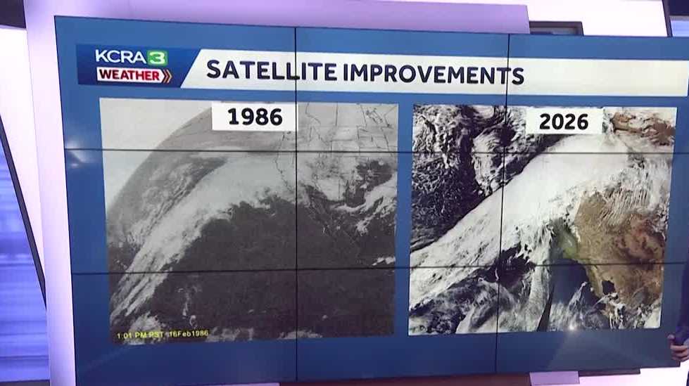
Fortunately, water managers, hydrologists and meteorologists can better see these risks coming ahead of time.
The internet has revolutionized how water and weather data can be gathered and shared in real time.
Major improvements in satellite technology, radar coverage and weather forecast models give forecasters insights into events much further out in time compared to 40 years ago.
Reservoir operations have also been re-evaluated. Many now take medium-range weather forecasts into account.
A lower spillway on Folsom Dam allows for faster releases ahead of major storms. A similar spillway is in the works on New Bullards Bar with plans fully drafted. Updates to the reservoir’s water control manual are scheduled to be operational in 2027.