
Northern California forecast: Chilly start to Saturday
Saturday is off to a chilly start, but temperatures warm as clouds decrease this afternoon and above normal temperatures are forecast for Sunday afternoon.
LET’S GET A CHECK OF OUR FORECAST NOW WITH KELLY. YOU’RE TALKING ABOUT SOME RAIN TOTALS FOR US. YEAH, YEAH. LAST WEEK WAS IMPRESSIVE RIGHT. WITH THE RAIN AND THE SNOW THAT WE RECEIVED. SO LET’S TAKE A LOOK AT THE UPDATED RAIN SEASON SO FAR. SO WITH ALL THE RAIN THAT WE RECEIVED LAST WEEK, STOCKTON NOW UP TO 11.8IN, WHICH IS 134% OF NORMAL. WE LOVE THAT SACRAMENTO ALMOST 12.5IN NOW FOR THE SEASON, WHICH AGAIN STARTS OCTOBER 1ST. SO WE’RE OVER 100% OF NORMAL. WE LIKE TO SEE A LITTLE HIGHER THOUGH. MODESTO 10.9IN 137% OF WHAT IS CONSIDERED NORMAL FOR THIS TIME OF YEAR. SO CERTAINLY GOOD NEWS. WE HAD THAT LONG DRY SPELL AND NOW WE HAVE CAUGHT UP A LITTLE BIT. RIGHT NOW IN SACRAMENTO, WE CERTAINLY SEE QUITE A FEW CLOUDS AROUND, BUT IT IS COLD. IT’S 35 DEGREES. THAT’S THREE DEGREES ABOVE FREEZING. THE WINDS ARE CALM, RELATIVE HUMIDITY ABOUT 92%. NOW WE DO HAVE A COLD WEATHER ADVISORY. THAT’S FOR ALL THE AREAS SHADED IN THIS LIGHT BLUE. THIS GOES THROUGH 10 A.M. THIS INCLUDES THE SIERRA PARTS OF THE FOOTHILLS AS WELL AS WE’RE TALKING ABOUT BELOW FREEZING TEMPERATURES AND THE POSSIBILITY FOR SOME SLICK, ICY ROADS. SO DO TAKE IT EASY IF YOU’RE TRAVELING EARLY THIS MORNING. SATELLITE RADAR PICTURE REALLY NOT SHOWING MUCH OF ANYTHING AND WE JUST HAVE A FEW CLOUDS AROUND. BUT LET’S TAKE A LOOK AT FUTURECAST BECAUSE LOOK AT THIS BEAST. THIS IS OUT IN THE PACIFIC RIGHT NOW. NOW THIS LOW IS ACTUALLY GOING TO SPLIT INTO TWO HERE IN THE COMING DAYS. SO THIS IS SUNDAY AFTERNOON. AND NOTICE WE’RE GOING TO START SEEING SOME ACTIVE WEATHER MOVING INTO THE FAR NORTHERN PARTS OF CALIFORNIA. BUT NOT REALLY IN OUR VIEWING AREA, AT LEAST NOT YET. THAT’S GOING TO BE COMING AS WE GET INTO SUNDAY NIGHT OR RATHER MONDAY NIGHT. SO MONDAY MORNING, NO PROBLEMS. GET UP, DRY COMMUTE FOR THE FOR EVERYBODY HEADING TO WORK. AS WE HEAD INTO THE EVENING THOUGH IN THE OVERNIGHT HOURS, THAT’S WHEN THE RAIN IS GOING TO START MOVING IN. THAT’S GOING TO CONTINUE THROUGHOUT THE DAY ON TUESDAY. AND NOTICE WHERE YOU SEE A LITTLE BIT OF PINK HERE. THIS STORM SYSTEM IS GOING TO BE SIGNIFICANTLY WARMER THAN THE LAST ONE. SO WE’RE NOT GOING TO SEE SNOW LEVELS THAT LOW. IN FACT, SNOW LEVELS ARE GOING TO BE VERY HIGH WITH THIS ONE. SO SOME OF THE AREAS THAT RECEIVED SNOW LAST TIME ARE GOING TO GET RAIN ON TOP OF THE SNOW, WHICH CAN MAKE FOR A LITTLE BIT OF AN ICY MIX, ESPECIALLY EARLY IN THE MORNING. WE MIGHT SEE A FEW LINGERING SHOWERS AS WE GET INTO WEDNESDAY, THEN DRY CONDITIONS AS WE ROUND OUT THE REST OF THE WORKWEEK. IN FACT, GETTING CLOSE TO 70 BY FRIDAY AND ANOTHER STORM SYSTEM WILL TRY. THIS IS THE SECOND HALF OF THAT SAME LOW WILL TRY TO MOVE ITS WAY IN AS WE HEAD INTO THE EARLY PART OF NEXT WEEK. NOW, AS FAR AS THE CONDITIONS FOR TUESDAY, TUESDAY IS THE DAY THAT WE’RE GOING TO SEE THE RAIN. IT’S GOING TO BE AN IMPACT DAY FOR STEADY RAIN. WET SNOW AT 7000 PLUS FEET IS GOING TO BE A LITTLE BIT BREEZY, AND WE’RE NOT EXPECTING ANY THUNDERSTORMS. SEVEN DAY FORECAST TODAY IN THE FOOTHILLS MID-FIFTIES.
Northern California forecast: Chilly start to Saturday
Saturday is off to a chilly start, but temperatures warm as clouds decrease this afternoon and above normal temperatures are forecast for Sunday afternoon.

Updated: 7:59 AM PST Feb 21, 2026
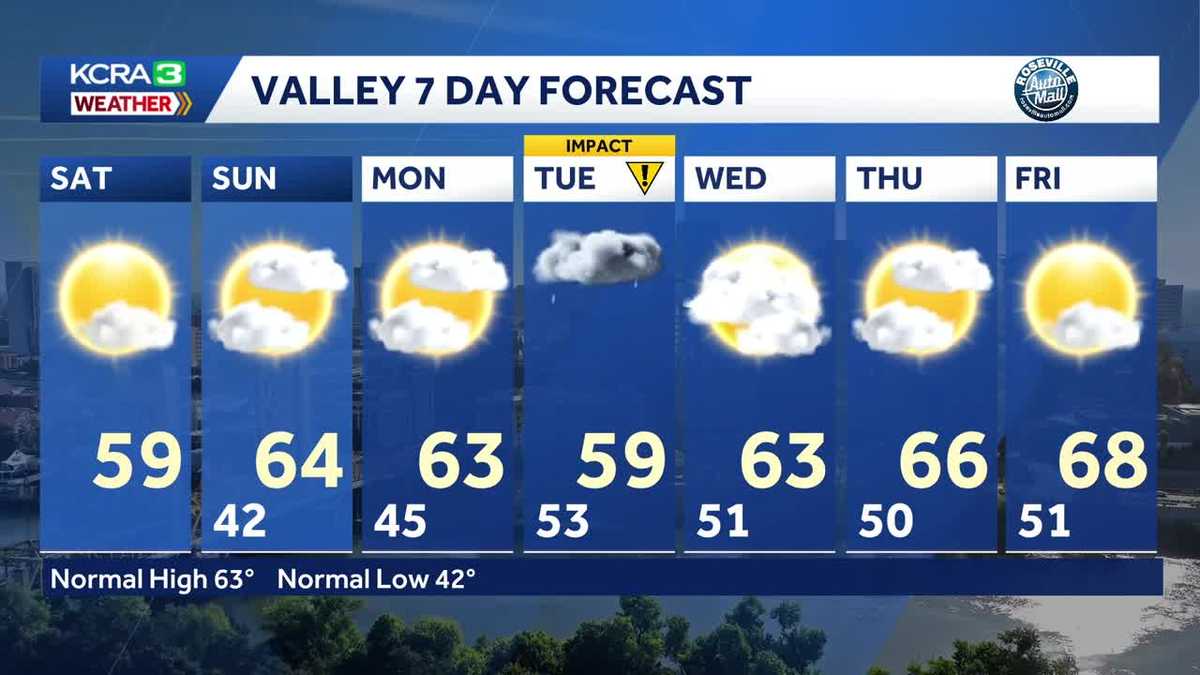
Saturday is off to another cold start with areas of frost possible. A Cold Weather Advisory for the Sierra and adjacent foothills is in place through 10:00 am as temperatures drop into the single digits and possibly as low as -5°F. Decreasing clouds and a SE breeze will help us warm up this afternoon with highs in the upper 50s and low 60s in Valley, mid 50s in the Foothills, and upper 30s in the Tahoe Basin. Temperatures will not be as cold overnight and afternoon highs on Sunday warm to near and even slightly above normal. Highs in Sacramento will reach the mid 60s on Sunday with a mix of sun and clouds. The next storm system arrives Monday night into Tuesday, creating a wet morning commute. Tuesday is an IMPACT Day. This system will be much warmer than the last one and will be primarily rain except at the higher terrain (>7,000′). A few showers will linger into Wednesday in the Foothills and Sierra while the Valley dries out. Thursday and Friday are dry and warmer… we may even see upper 60s and low 70s on Friday!
SACRAMENTO, Calif. —
Saturday is off to another cold start with areas of frost possible. A Cold Weather Advisory for the Sierra and adjacent foothills is in place through 10:00 am as temperatures drop into the single digits and possibly as low as -5°F.
Decreasing clouds and a SE breeze will help us warm up this afternoon with highs in the upper 50s and low 60s in Valley, mid 50s in the Foothills, and upper 30s in the Tahoe Basin.
Temperatures will not be as cold overnight and afternoon highs on Sunday warm to near and even slightly above normal. Highs in Sacramento will reach the mid 60s on Sunday with a mix of sun and clouds.
The next storm system arrives Monday night into Tuesday, creating a wet morning commute. Tuesday is an IMPACT Day. This system will be much warmer than the last one and will be primarily rain except at the higher terrain (>7,000′). A few showers will linger into Wednesday in the Foothills and Sierra while the Valley dries out.
Thursday and Friday are dry and warmer… we may even see upper 60s and low 70s on Friday!