
Northern California forecast: Dry weekend continues with clouds, breezes
As a large storm system churns off the West Coast, valley weather will remain dry but cloudy, with some breezes.
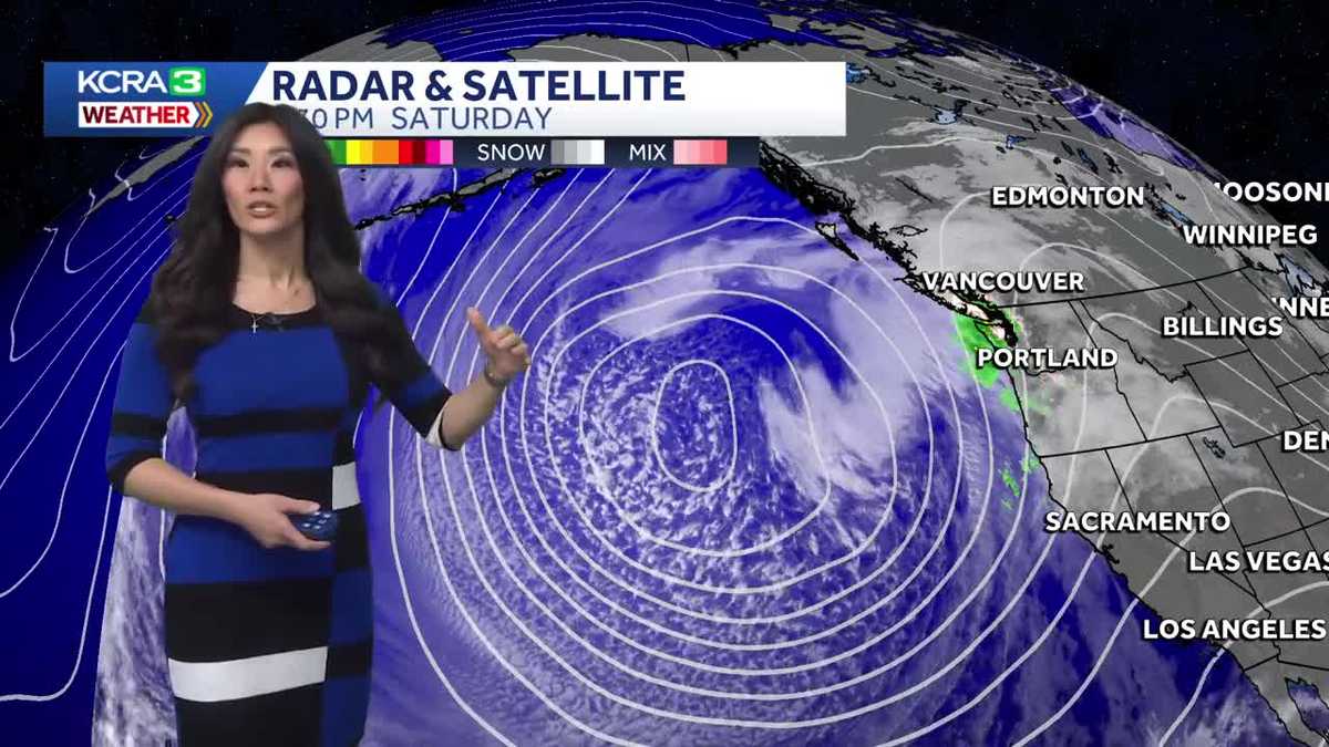
WAS CRAZY AT ONE POINT, I’M SURE FOLKS ARE HAPPY THAT THINGS HAVE CALMED DOWN A BIT. YES, IT’S NICE TO HAVE A COUPLE OF DAYS TO CLEAN UP. WE DO HAVE MORE RAIN, A LITTLE SNOW ON THE WAY, BUT TODAY WE HAD SOME SUN, WE HAD SOME CLOUDS. WE EVEN HAD A LITTLE WIND. WHAT WE DIDN’T HAVE WAS THE RAIN AND THE SNOW. AS WE LOOK OUTSIDE RIGHT NOW, EVEN THE CLOUDS THAT WE HAD THIS AFTERNOON HAVE CLEARED OUT. IT IS A NICE COOL EVENING, BUT TODAY WE DID WARM INTO THE UPPER 50S. IT WAS ALSO NICE TO HAVE NOT AS MUCH COLD EVEN THOUGH TEMPERATURES WERE STILL BELOW NORMAL. WE’RE WORKING OUR WAY THERE AND THE PLAN IS TO GET THERE TOMORROW. THIS MORNING, HOWEVER, WE GOT DOWN TO JUST ABOVE FREEZING. 34 DEGREES WAS A CHILLY START TO OUR SATURDAY. AT THE TIME WE HIT OUR HIGH, HOWEVER, TEMPERATURES HAD CLIMBED ANYWHERE FROM 8 TO 12 DEGREES WARMER THAN 24 HOURS PRIOR. AND GUESS WHAT? WE’RE STILL HOLDING ON TO SIMILAR NUMBERS RIGHT NOW FOR OUR WARM UP. SO YEAH, WE’RE COOLING DOWN, BUT WE’RE STILL DOING MUCH BETTER IN TERMS OF THE WARMTH THAN YESTERDAY AT THIS TIME. 55 IN SACRAMENTO AND STOCKTON. RIGHT NOW, MODESTO STILL JUST UNDER 60 DEGREES. NOT BAD. PLACERVILLE 52 DEGREES TRUCKEE AND SOUTH LAKE TAHOE JUST DROPPING IN THE 30S WILL BE DOWN INTO THE 40S AFTER 9:00. YOU HAVE PLANS FOR YOUR SATURDAY EVENING. GRAB THAT EXTRA LAYER WITH YOU BECAUSE YOU’LL NEED IT FOR THE REST OF YOUR EVENING, ESPECIALLY IF YOU’RE GOING TO BE OUT PAST MIDNIGHT. WE’RE GOING TO DROP TO MID 40S. WILL BOTTOM OUT AT 40 DEGREES BEFORE WE WARM BACK UP FOR YOUR SUNDAY, AND IT’S GOING TO BE AN EVEN WARMER BUT CLOUDY ONE. WE HAVE CLOUDS THAT ARE MOVING IN. AS YOU CAN SEE FROM THE SATELLITE IMAGERY, MAINLY TO OUR NORTH. AND THAT IS THANKS TO STORMS THAT ARE PUSHING INTO THE PUGET SOUND RIGHT NOW. AND THAT’S BEING DRIVEN IN BY THIS MASSIVE AREA OF LOW PRESSURE. AS YOU CAN SEE, SPINNING OFF IN THE OCEAN. WE ALSO HAVE HIGH PRESSURE HOVERING TO SACRAMENTO SOUTH. NOW, THIS AREA OF LOW PRESSURE IS SO MASSIVE THAT WE’RE WATCHING STORMS DEVELOP WITHIN ITS CYCLONIC ROTATION. SO THE START OF THIS WEEK IS GOING TO BE A CLASH BETWEEN THAT LARGE AREA OF LOW PRESSURE AND HIGH PRESSURE THAT CONTINUES TO HOVER TO OUR SOUTH. IT’S GOING TO TOGETHER DRIVE UP MOISTURE FROM THE TROPICS. WE HAVE RAIN ARRIVING TO NORTHERN CALIFORNIA ON TUESDAY. TUESDAY MORNING SHOULD BE A WET MORNING COMMUTE. MOST OF THE RAIN SHOULD FALL IN THE VALLEY TO OUR NORTH. IT DOES SHIFT SOUTH TUESDAY NIGHT, GOING INTO WEDNESDAY. BY WEDNESDAY AFTERNOON AND EVENING, MOST OF THE REGION SHOULD BE DRY AND WE’RE BACK TO A WARM REST OF THE WEEK. BUT BECAUSE THIS MOISTURE IS COMING IN AS FAR SOUTH AS THE HAWAIIAN ISLANDS, IT IS AN ATMOSPHERIC RIVER ENHANCED STORM. THE RAINS ARE GOING TO BE MUCH WARMER THAN THE LAST, WHICH MEANS IT’S GOING TO BE LESS READY TO TURN INTO SNOW. THAT SNOW LEVEL IS GOING TO REMAIN PRETTY HIGH. MOST OF THE PRECIPITATION IN THE SIERRA GOING TO FALL AS RAIN. HOW MUCH ARE WE TALKING ABOUT? UP TO 2.5IN OF RAIN ABOVE 6500FT, MAYBE EVEN 7000FT IS WHEN YOU’LL FIND SOME SNOW. FOOTHILLS AND COASTAL RANGE FORECAST AMOUNTS UP TO 1.5IN. AND IN THE VALLEY, LOOKING FROM ANYWHERE FROM A QUARTER TO A HALF INCH OF RAIN. AND OF COURSE, THIS IS AN ATMOSPHERIC RIVER. SO REALLY DEPENDS ON WHERE THAT FIRE HOSE OF MOISTURE POINTS. RIGHT? SO WE’LL CERTAINLY BE WATCHING OUT FOR THAT. BUT BECAUSE THIS MOISTURE ORIGIN IS FROM A WARMER AREA AGAIN AS FAR SOUTH AS HAWAIIAN ISLANDS, OUR WARM UP OR COOL DOWN RATHER ON TUESDAY IS NOT GOING TO BE AS DRAMATIC. WE’LL BE DOWN TO UPPER 50S, WHICH IS WHAT WE HAD TODAY BEFORE WE WARM BACK UP AFTER WE DRY OUT AND CHECK OUT AT THE END OF YOUR SEVEN DAY FORECAST, WE’RE FLIRTING WITH THE 70S AGAIN, WHICH I HAVE NO PROBLEM SAYING. AFTER A FEW GOOD STORMS WE CAN DR
Northern California forecast: Dry weekend continues with clouds, breezes
As a large storm system churns off the West Coast, valley weather will remain dry but cloudy, with some breezes.

Updated: 7:17 PM PST Feb 21, 2026
As a large storm system churns off the West Coast, valley weather will remain dry but cloudy, with some breezes.Sunday will also be warmer as breezes flow out of the south. Highs in the valley will reach the low to mid-60s. Temperatures will also peak in the low 60s in the foothills and the low to mid-40s in the Sierra. Winds will be most noticeable in the valley and foothills, blowing out of the south at 10-15 mph, with gusts up to 25 mph.Monday’s weather will be similar–mostly cloudy with some breezes and seasonably warm temperatures.As the weather system drives moisture into the region, however, the chance of rain increases overnight into Tuesday morning, and Tuesday will be an Impact Day for rainy conditions.Because this system will be enhanced by an atmospheric river, rainfall is expected to be relatively warm, and snow levels will remain above 6,500 feet in elevation. Even at the peaks, however, only a few inches of snow are forecast.The valley may receive 0.25 to 0.50 inches of rain, with as much as 1.5 inches forecast in the foothills. Precipitation will mainly be rain in the Sierra, where as much as 2.5 inches may fall.A few showers will linger into the first half of Wednesday, and the weather will dry out for the rest of the week. While some cloud cover will stick around, high temperatures are expected to warm into the upper 60s by the end of the week.
SACRAMENTO, Calif. —
As a large storm system churns off the West Coast, valley weather will remain dry but cloudy, with some breezes.
Sunday will also be warmer as breezes flow out of the south. Highs in the valley will reach the low to mid-60s. Temperatures will also peak in the low 60s in the foothills and the low to mid-40s in the Sierra. Winds will be most noticeable in the valley and foothills, blowing out of the south at 10-15 mph, with gusts up to 25 mph.
Monday’s weather will be similar–mostly cloudy with some breezes and seasonably warm temperatures.
As the weather system drives moisture into the region, however, the chance of rain increases overnight into Tuesday morning, and Tuesday will be an Impact Day for rainy conditions.
Because this system will be enhanced by an atmospheric river, rainfall is expected to be relatively warm, and snow levels will remain above 6,500 feet in elevation. Even at the peaks, however, only a few inches of snow are forecast.
The valley may receive 0.25 to 0.50 inches of rain, with as much as 1.5 inches forecast in the foothills. Precipitation will mainly be rain in the Sierra, where as much as 2.5 inches may fall.
A few showers will linger into the first half of Wednesday, and the weather will dry out for the rest of the week. While some cloud cover will stick around, high temperatures are expected to warm into the upper 60s by the end of the week.