
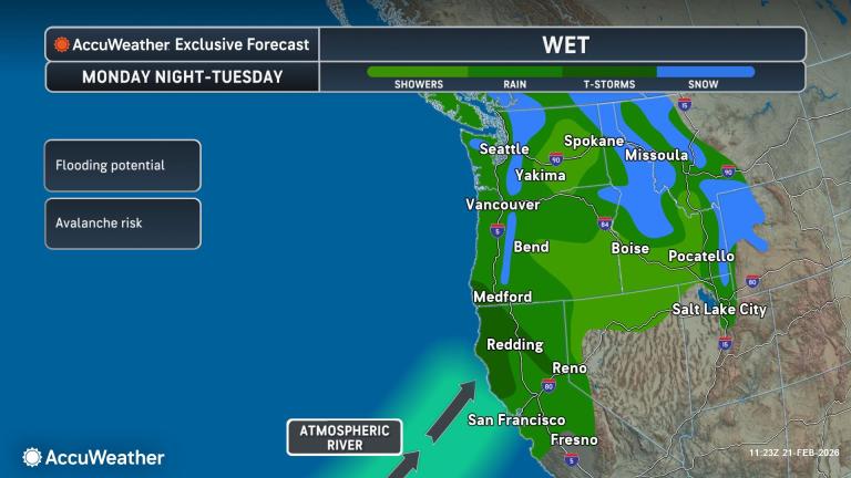
A series of Pacific storms will bring renewed flooding downpours, gusty winds and heavy snow to the Northwest and Northern California into Tuesday. The snow levels will be much higher than with the storm last week.
Published Feb 21, 2026 11:06 AM CST
|
Updated Feb 21, 2026 11:15 AM CST
After days of wintry weather, Feb. 19 provided little relief from extreme amounts of snow in the mountains of California.
A new series of Pacific storms will renew flooding concerns along the West coast and bring heavy snow to higher elevations.
Low pressure off the Pacific coast will sweep towards British Columbia Sunday into early Monday. In advance of it, rain will spread onto the coast while snow slams the Cascades and northern Rockies. Rain totaling 1-3 inches will soak the Interstate 5 corridor from Washington into Oregon and far Northern California through Monday night. Since this same area was clocked with 1-3 inches of rain this past week, flooding will be more likely due to already saturated soil.
As if one storm isn’t enough, a fresh Atmospheric River will slam into Northern California Monday night into Tuesday morning. This concentrated plume of Pacific moisture will be directed into Northern California, where another 1-3 inches of rain will foster more flooding. The remainder of the Interstate 5 corridor in the Northwest will see an additional inch or so of rain, which combined with earlier week rain and saturated soil will increase the risk of more flooding.
Rain will expand into the San Francisco Bay Area and northern San Joaquin Valley Tuesday afternoon. “The main spots prone to flooding will be just north of San Francisco Bay in areas of rugged terrain and in the Sierra foothills of Central California,” according to AccuWeather Meteorologist Kai Kerkow.
Wind gusts of 40-50 mph are expected along the Northwest Coast on Sunday, which could result in isolated power outages and downed tree limbs.
Snow levels will be much higher than with the storm last week.
“The storm moving into California through early next week will be much warmer than the series of storms that hit the state last week. Snow levels will be confined primarily above 8,000 feet, limiting travel impacts to the highest mountain passes,” said Kerkow.
Have the app? Unlock AccuWeather Alerts™ with Premium+
The storm will push the Sierra snow moisture content even closer to the historical average. According to the latest snowpack data, the Northern Sierra remains 12% below the historical average, while the Central and Southern Sierra are 16–21% below average. Even after the monster storm last week, the water content in the snow is still below average simply due to the large gap between winter storms this year.
Snow totaling 5-10 inches will blanket the Cascades into the Siskiyou Mountains this weekend. Avalanche risk will increase above 4,500 feet, particularly where heavy, wet snow accumulates.
Across the Cascades and Siskiyou Mountains above 4,500 feet, 5-10 inches of heavy wet snow is expected this weekend. The storm will shift into the northern Rockies Tuesday into Wednesday, with 8-12 inches of snow expected above 5,500 feet.
High pressure is expected to bring a period of dry weather to the West from Wednesday into at least early next weekend.
Want next-level safety, ad-free? Unlock advanced, hyperlocal severe weather alerts when you subscribe to Premium+ on the AccuWeather app. AccuWeather Alerts™ are prompted by our expert meteorologists who monitor and analyze dangerous weather risks 24/7 to keep you and your family safer.