
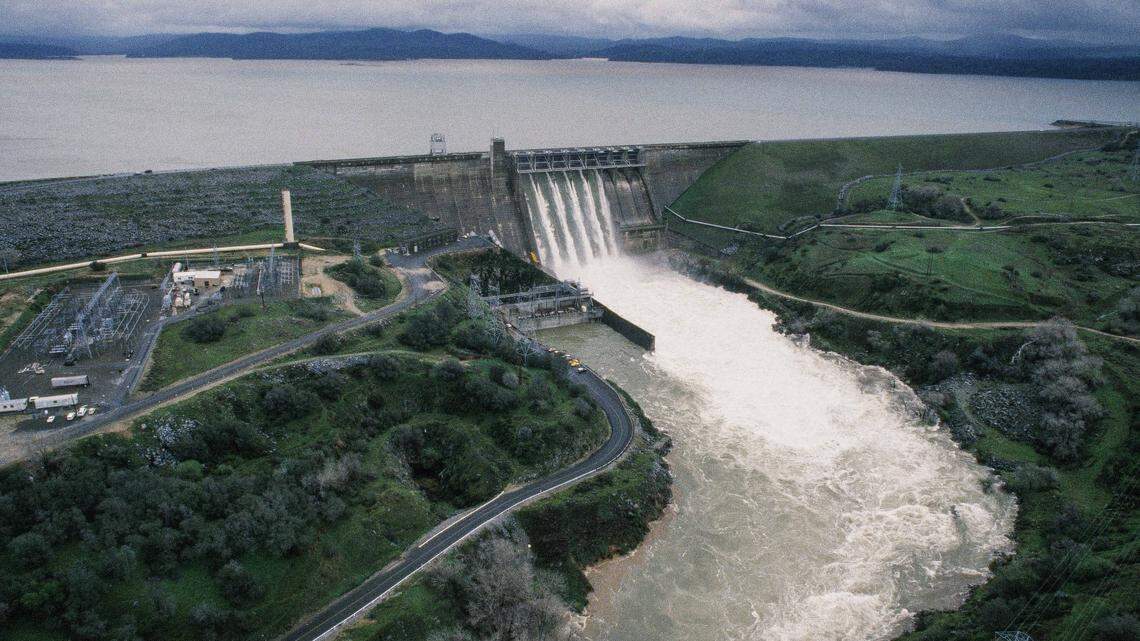
Folsom Dam discharges water at a high rate on Feb. 19, 1986.
DAVID LaBELLE
Sacramento Bee file
The winter of 40 years ago in Sacramento was eerily reminiscent of the current one, with a bone-dry January as storms bypassed the region to the north. Then a band of moisture originating in Hawaii put a bull’s-eye on Northern California.
More water raced down the American River 40 years ago Thursday than Folsom Dam had ever experienced, then or now. Had the river risen just 6 more inches, or had the storm lasted a few more hours, much of Sacramento would have likely been underwater.
The fear of flooding has steadily faded in Sacramento because of what happened after the great storms of 1986.
Sacramento came together and created flood control protections, arguably the most effective regional government effort in local history. And now, some $5 billion in flood protection improvements later, Sacramento is almost ready for much bigger storms.
Still, this region does not take flooding as seriously as it should. Public attention is far more focused on how a warming climate increases the risk of wildfires and heat waves. But hotter temperatures are also creating more vapor in the atmosphere, a flood waiting to happen.
It’s just a matter of time until nature organizes that vapor into rivers in the sky that will someday come crashing down on Sacramento. And when it does, all the work over the last 40 years will be put to the test.
City workers test one of two floodgates on H Street between East Sacramento and River Park as the rising American River threatens the city on Feb. 18, 1986. RANDY PENCH Sacramento Bee file A flood that key players will never forget
Those who fought the flood of 1986 will never forget it.
“It was an incredibly scary time,” said Joe Countryman, who engineered many of these improvements and was the regional leader of the U.S. Army Corps of Engineers at the time. Countryman, as part of a group effort, urged for officials to forgo prevailing operational rules and release more water down the American River early on to avoid the prospect of even bigger releases later that would have flooded the city. The gamble paid off, but barely.
Many things went wrong 40 years ago. The operators of Folsom Dam at the Bureau of Reclamation, initially more concerned about water supplies for the summer, didn’t release enough water because they didn’t take the coming storms seriously. To be fair, the first weather forecast turned out to be wrong by a factor of 10.
The storms began arriving on Feb. 17. Imagine nearly 50 inches of rain falling in just 10 days. That’s what happened at Bucks Lake in Plumas County.
By 5 p.m. on Feb. 18, Folsom Dam was 97% full. Folsom holds about 1 million acre-feet of water. An acre-foot is about 325,000 gallons of water. The flow into Folsom was as high as 200,000 cubic feet per second. That’s a terrifying 1.5 million gallons of water flowing from the mountains toward the dam each and every second.
Flood operations then and now call for a maximum release from Folsom of 115,000 cubic feet per second; Countryman called for a release of 130,000. Adjusting Folsom’s massive gates is an imperfect exercise. The dam actually began releasing 134,000 cubic feet per second. And on Feb. 19, everyone held their breath.
Spectators watch the high-flowing American River slide under the Guy West Bridge in Sacramento on Feb. 18, 1986. RANDY PENCH Sacramento Bee file
There was localized flooding in places like Rio Linda along Dry Creek and in Strawberry Manor near Arcade Creek. On the American River, on a canal northward into Natomas, water levels came within six inches of the canal’s top. The record releases down the river lasted 20 hours. And then Countryman’s daughter, Kelly, ran into his office to announce the good news. Finally in Sacramento, it had stopped raining.
“We were within hours, I would say, of potential failure,” Countryman said.
A success in regionalism
Sacramento had relied on state and federal agencies and a disparate group of local flood and reclamation districts for its safety. In 1989, the Sacramento Area Flood Control Agency was created, a joint powers authority serving most of Sacramento County and southern Sutter County.
Change couldn’t happen without public support. SAFCA’s Tim Washburn, now recently retired, led a task force to engage river activists on possible solutions. “There was a particular focus on erosion,” Washburn said. The subsiding waters after the 1986 flood revealed scouring that had been eating away at the levees. Erosion work in 1996 behind River Park, for example, was completed just in time for storms in 1997 that required the release of 115,000 cubic feet per second into the river. The American has not flowed that high ever since.
A man tries to round up horses in the flooded stables at Cal Expo in Sacramento on Feb. 18, 1986. RANDY PENCH Sacramento Bee file
Upstream, the political solution to flooding focused for years on a new dam above Folsom on the North Fork of the American River near Auburn, one long championed by The Bee. The problem was settling on its design. Environmental groups that initially supported a dam insisted that it be only for flood control, with a giant hole at its base. Upstream advocates like Rep. John Doolittle of Placer County wanted a dam for water supply, which then eroded support for any kind of dam.
“It was Congressman Doolittle who helped us see the error of our initial ability to consider the project,” said long-time advocate Ron Stork of Friends of the River. By 1998, a slim majority of the SAFCA voted to focus on downstream solutions. The quest to build the dam eventually died.
Incrementally, progress was made. Levees were raised in certain sections to be the same level as on the other side. Miles of levees were carved open in the middle, filled with an impermeable slurry. An auxiliary spillway was constructed on Folsom to release more water earlier in storms. And along the Sacramento River, new levees were built to protect the deep floodplain of the Natomas Basin surrounding the Sacramento International Airport.
Kim Johnson waits for the cleanup to begin at her mother-in-law’s house in the Strawberry Manor neighborhood of Sacramento after Arcade Creek flooded the area in 1986. GENARO MOLINA Sacramento Bee file
“We have made Natomas the most impregnable floodplain in Sacramento,” said Countryman, who is so confident in the levees that he now lives in the community.
None of this happened without intense outreach to neighborhoods. An American River task force led by SAFCA’s Tim Washburn is the shining example. One erosion project next to the River Park community, requiring tons of rock below soil and vegetation, was so popular in 1996 that SAFCA dismissed the need for an environmental review and nobody sued. It likely saved River Park the next year, when storms required the release of 115,000 cubic feet per second. The lower American hasn’t seen that amount of water ever since.
We are in danger of forgetting Sacramento’s past
The SAFCA goal is for a lower American River to be both scenic and strong, capable of safely managing flows as high as 160,000 cubic feet per second. But that will require the widening of a weir on the Sacramento River to guide those flows into the Yolo Bypass, a project under way. And the lower American still needs more erosion work like what saved River Park, including projects east of Howe Avenue.
But now, there is opposition. Neighbors dismissing the need for such extensive work have delayed the project in federal court, a judge ruling last year that the environmental analysis was inadequate. It was a shocking decision that risked a public safety disaster. It is as if we have forgotten the past and have no fear of what future storms may bring.
Water submerges homes in the Strawberry Manor neighborhood of Sacramento on Feb. 25, 1986, after Arcade Creek, right, escaped its banks. RANDY PENCH Sacramento Bee file
In Natomas, Countryman says he has neighbors who had no idea that their homes were protected by enormous levees along the Sacramento River. “I had to take them over,” he said.
Sacramento finds itself a victim of its own successes on flood protection. “We’ve actually done a pretty good job of addressing the problem,” Washburn said.
But Sacramento’s flood work is not done. Countryman, preaching the need for continued maintenance, knows it will never be done. We are closer to an American River that can handle bigger storms than we have ever seen. But we are not there yet. And now we have only ourselves to blame.
“You can’t take your eye off the ball,” Washburn said. Yet too many of us have.
Related Stories from Sacramento Bee
Tom Philp is a Pulitzer Prize-winning editorial writer and columnist who returned to The Sacramento Bee in 2023 after working in government for 16 years. Philp had previously written for The Bee from 1991 to 2007. He is a native Californian and a graduate of the Medill School of Journalism at Northwestern University.