
Northern California forecast: Pleasant Sunday but more wet weather is on the way
A few light showers are brining wet weather to the coast and coastal ranges early on this Sunday with a few showers possible near Yuba City, but most of the KCRA viewing area remain dry with seasonable temperatures.
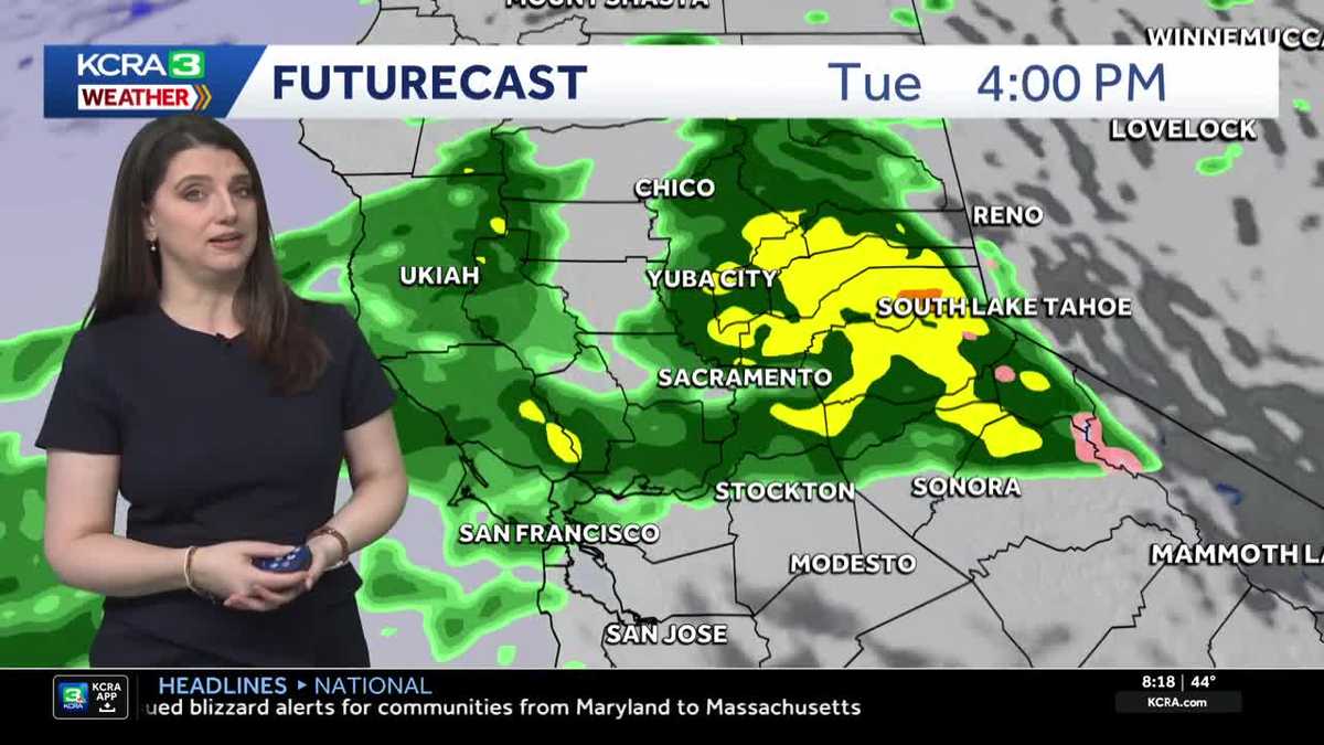
METEOROLOGIST KELLY CURRAN IS TRACKING CONDITIONS OUT THERE FOR US. HOW’S IT LOOKING FOR THIS SUNDAY? YOU KNOW WHAT? IT’S REALLY LOOKING GREAT. WE’RE SEEING BEAUTIFUL BLUE SKY RIGHT NOW HERE IN SACRAMENTO. YEAH, SURE. IT’S A LITTLE CHILLY. WE’RE AT 44 DEGREES, BUT THAT IS WARMER THAN THE LAST TWO MORNINGS, THAT’S FOR SURE. WINDS ARE CALM. NO PROBLEMS THERE. NOW, AS FAR AS THE SATELLITE RADAR COMPOSITE LOOKS KIND OF FREEZING ON US HERE A LITTLE BIT, BUT WE ARE TRACKING SOME RAIN SHOWERS THAT ARE MOVING THEIR WAY THROUGH LAKE COUNTY. COLUSA COUNTY. WE’VE SEEN A LITTLE BIT OF THAT ACTION UP TOWARD YUBA CITY. LIKE I SAID, THE RADAR SEEMS TO BE HAVING A LITTLE FREAK OUT ON US AT THE MOMENT. NOW, AS FAR AS FUTURECAST GOES, HERE’S THOSE RAIN SHOWERS THAT WE’VE BEEN TALKING ABOUT. YOU’RE SEEING THOSE COLUSA COUNTY, LAKE COUNTY. WE’VE EVEN SEEN A FEW OVER TOWARD CHICO AND YUBA CITY. THESE ARE GOING TO BE WINDING DOWN AS WE HEAD THROUGH THE AFTERNOON HOURS. SO MOST OF US STAYING DRY. NOTICE QUITE A BIT OF SUNSHINE, EVEN MORE AS YOU HEAD DOWN TOWARDS STOCKTON MODESTO. NOW OVERNIGHT TONIGHT WE’RE GOING TO SEE SOME MORE CLOUDS MOVING IN, BUT A DRY COMMUTE TOMORROW MORNING. NO PROBLEMS THERE AS WE HEAD INTO TOMORROW AFTERNOON. SAME THING FOR THE EVENING COMMUTE. LOOKS OKAY, BUT WE’RE GOING TO START SEEING THAT RAIN CREEPING IN. SO YOU SEE THAT AROUND LAKE COUNTY STARTING TO MOVE INTO COLUSA COUNTY IN THE EVENING. THEN AS WE HEAD THROUGH THE OVERNIGHT, THAT’S WE’RE GOING TO START SEEING THOSE RAIN SHOWERS SPREADING ACROSS THE REGION. NOW, YOU NOTICE THAT MORE OF THE HEAVIER RAIN COMES DOWN IN THE HIGHER TERRAIN. SO THE FOOTHILLS OVER INTO THE COASTAL RANGES AND THEN UP INTO THE SIERRA, WHERE IT’S PRIMARILY GOING TO BE A RAIN EVENT FOR US. THE STORM IS MUCH WARMER THAN THE LAST ONE. SO NOT ONLY WILL THE MORNING COMMUTE BE WET ON TUESDAY, BUT SO WILL THE EVENING COMMUTE. AND THAT’S WHY IT’S GOING TO BE AN IMPACT DAY FOR US. IT IS CERTAINLY GOING TO CREATE SOME SLICK ROADS BY WEDNESDAY MORNING. JUST A FEW LINGERING SHOWERS AND THEN WE ARE DONE. HOW MUCH RAIN ARE WE AS FAR AS THE IMPACT GOES? IT’S STEADY RAIN. THAT’S THAT’S THE MAIN ISSUE THAT WE’RE GOING TO BE DEALING WITH SNOW. THE SNOW LEVELS ARE GOING TO BE AT OR ABOVE 7000FT. SO EVEN THROUGH THE PASSES, YOU’RE STILL GOING TO SEE AT LEAST PRIMARILY RAIN. AND THEN SWITCHING OVER TO THAT HEAVY, WET SNOW. WHEN YOU GET THAT RAIN ON TOP OF THE SNOW, THAT’S WHEN YOU KIND OF GET THAT CRUSTY, ICY LAYER OVER THE TOP. SO THAT’S JUST SOMETHING TO KEEP IN MIND. WE MIGHT ALSO SEE SOME SLICK ROADS, THE VALLEY LOOKING AT A HALF AN INCH OF RAIN OR LESS FROM THIS SYSTEM, ESPECIALLY AS YOU HEAD DOWN TOWARDS STOCKTON MODESTO WHERE YOU PROBABLY SEE A QUARTER OF AN INCH OR LESS FOR THE FOOTHILLS AND FOR THE COASTAL HILLS, UP TO AN INCH AND A HALF, AND FOR THE SIERRA UP TO 2.5IN. SEVEN DAY FORECAST. LOOKING GOOD FOR TODAY AND TOMORROW IN THE FOOTHILLS, BUT AGAIN WEDNESDAY, TUESDAY INTO EARLY WEDNESDAY. WE’RE GOING TO SEE OUR NEXT ROUND FOR RAIN FOR THE SIERRA. WE’LL SEE DRY CONDITIONS TODAY AND TOMORROW AND THEN THAT MIXED PRECIPITATION AS WE GET INTO TUESDAY AND WEDNESDAY. AND FOR THE VALLEY. NOT BAD TODAY AND TOMORROW. HIGHS IN THE 60S AND THEN IMPACT DAY. GET THE UMBRELLAS READY. RAIN IS COMING FOR ALL DAY TUESDAY. ALL RIGHT.
Northern California forecast: Pleasant Sunday but more wet weather is on the way
A few light showers are brining wet weather to the coast and coastal ranges early on this Sunday with a few showers possible near Yuba City, but most of the KCRA viewing area remain dry with seasonable temperatures.

Updated: 8:40 AM PST Feb 22, 2026
Scattered showers are occurring along the coast and in the coastal ranges this morning. An isolated shower or two is possible on the west side of the Sacramento Valley, but most of us will remain dry today with a few clouds and warmer temperatures.Dry conditions are expected Monday as well with the next storm system moving in during the overnight hours and into Tuesday. Tuesday is an IMPACT DAY. Rain showers will impact the morning commute, and scattered showers may impact the evening commute as well. Snow levels will be quite high (above 6,500′) making this primarily a rain event, even for the Sierra. Rainfall totals will likely stay under 0.50″ in the Valley with the Sacramento Valley receiving more than the San Joaquin Valley. The Foothills could see up to 1.50″. Rain falling on snow could create an icy, crunchy layer over the snow and create slick road conditions. A few lingering showers are possible Wednesday, then dry conditions are forecast through Saturday with warming temperatures. Afternoon highs will be in the upper 60s and low 70s by the end of the week.
SACRAMENTO, Calif. —
Scattered showers are occurring along the coast and in the coastal ranges this morning. An isolated shower or two is possible on the west side of the Sacramento Valley, but most of us will remain dry today with a few clouds and warmer temperatures.
Dry conditions are expected Monday as well with the next storm system moving in during the overnight hours and into Tuesday. Tuesday is an IMPACT DAY. Rain showers will impact the morning commute, and scattered showers may impact the evening commute as well. Snow levels will be quite high (above 6,500′) making this primarily a rain event, even for the Sierra. Rainfall totals will likely stay under 0.50″ in the Valley with the Sacramento Valley receiving more than the San Joaquin Valley. The Foothills could see up to 1.50″. Rain falling on snow could create an icy, crunchy layer over the snow and create slick road conditions.
A few lingering showers are possible Wednesday, then dry conditions are forecast through Saturday with warming temperatures. Afternoon highs will be in the upper 60s and low 70s by the end of the week.