
Northern California forecast: Rain on the way
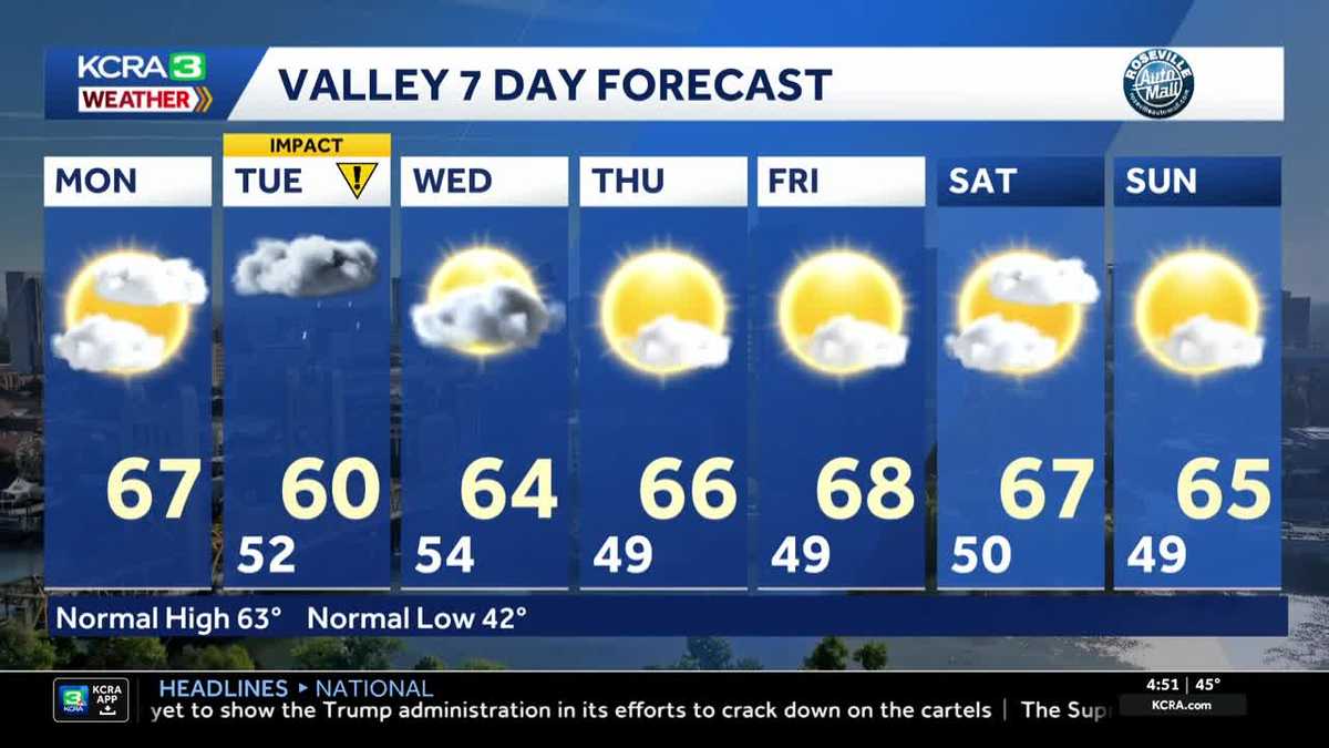
Dry and mild Monday with a mix of sun and clouds but rain showers move in overnight. Tuesday is an IMPACT DAY for Northern California for rain and gusty winds.
12 AND 18IN OF SNOW. IT’S A MUCH DIFFERENT STORY HERE IN OUR REGION, AT LEAST RIGHT NOW. ANYWAY, HERE’S A LIVE LOOK HERE STOCKTON ALL DRY AND CLEAR CURRENTLY, BUT ANOTHER STORM SYSTEM IS HEADED OUR WAY THIS WEEK. IT IS, BUT IT’S GOING TO BE A MUCH WARMER SYSTEM THAN THE LAST ONE. SO UNFORTUNATELY WE’RE NOT GOING TO BE GETTING ANY FRESH SNOW FOR THE SKIERS. THIS IS GOING TO BE A RAIN EVENT FOR US, BUT LET’S TAKE A LOOK AT WHAT’S HAPPENING ON THE EAST COAST. AND THERE YOU SEE THAT SNOW. THE ENTIRE STATE OF NEW JERSEY. YOU HAVE NEW YORK, CONNECTICUT, RHODE ISLAND AND EVEN INTO MASSACHUSETTS. WE’RE SEEING THAT SNOW CONTINUING TO COME DOWN. NOW, SNOW TOTALS IN THIS AREA COULD BE POTENTIALLY 1 TO 2FT, BUT IT’S NOT THE SNOW THAT PROMPTS THAT BLIZZARD WARNING. IT’S THE WIND. SO NOT ONLY ARE WE DEALING WITH SOME PRETTY SIGNIFICANT SNOW TOTALS HERE, BUT WE’RE GOING TO BE DEALING WITH TREES DOWN, POWER LINES DOWN. OF COURSE, POWER OUTAGES WHEN YOU’RE DEALING WITH THIS KIND OF WEATHER, NOT A GOOD THING TO BE DEALING WITH. AND HUGE SNOW DRIFTS BECAUSE OF THE WIND THAT WE’RE GOING TO BE DEALING WITH HERE AT HOME, MUCH QUIETER SITUATION. JUST A FEW CLOUDS AROUND THIS MORNING, 44 DEGREES RIGHT NOW IN SACRAMENTO. WE’RE GOING TO BE CLIMBING INTO THE MID AND EVEN UPPER 60S, THOUGH FOR LATER IN THE DAY. CLOUDS. THOSE ARE GOING TO BE INCREASING FOR US HERE AS WELL. NOW, AS WE TAKE A LOOK AT THE CURRENT SATELLITE RADAR IMAGERY, YOU DO SEE QUITE A FEW CLOUDS THAT ARE MOVING THEIR WAY THROUGH THE REGION, ESPECIALLY AROUND SACRAMENTO, BACK TOWARD FAIRFIELD AND SAC AND SAN FRANCISCO. THIS MORNING. WE’RE GOING TO SEE MORE OF THOSE AS WE HEAD LATER INTO THE DAY. SO THIS IS A LOOK AT FUTURECAST AND HOW WE EXPECT THINGS TO PLAY OUT. WE’RE EXPECTING DRY CONDITIONS THROUGHOUT THE DAY TODAY, SO NO MAJOR HICCUPS THERE. I DO THINK WE’LL SEE QUITE A BIT OF SUNSHINE, ESPECIALLY AS WE HEAD THROUGH THE NOON HOUR. BUT THEN AS WE HEAD INTO THE AFTERNOON AND EVENING, THAT’S WHEN YOU SEE MORE CLOUDS START TO PUSH IN. BY 6:00, WE’RE ALREADY GOING TO BE SEEING THOSE SHOWERS CLOSER TO THE COAST, MOVING THEIR WAY INTO LAKE COUNTY. THEN AS WE HEAD AROUND MIDNIGHT, YOU SEE THE HEAVIER RAIN FOR THE COAST AND THE COASTAL HILLS. WE’RE STARTING TO SEE SOME MORE SHOWER ACTIVITY HERE IN THE SIERRA, THE FOOTHILLS, A LITTLE BIT OF SNOW IN THE SIERRA BECAUSE WHEN THE SYSTEM STARTS, THE OVERNIGHT HOURS, SNOW LEVELS WILL BE AROUND 6500FT. BUT AS WE HEAD INTO THE DAYTIME HOURS OF TUESDAY, THOSE SNOW LEVELS CLIMB TO 10,000FT. SO AGAIN, PRIMARILY A RAIN EVENT EVEN FOR THE SIERRA. WE’LL SEE SOME SCATTERED SHOWERS IN THE VALLEY FOR THE MORNING COMMUTE. SO SOMETHING TO KEEP IN MIND AND WE’LL SEE MORE SCATTERED SHOWER ACTIVITY AS WE HEAD INTO THE AFTERNOON AND EVENING COMMUTE, ESPECIALLY IN THE FOOTHILLS OF THE SIERRA. THAT’S WHERE WE’RE GOING TO SEE THE HEAVIEST RAIN IN THE HIGHER TERRAIN IS GOING TO BE IN THE AFTERNOON THERE. NOW, AS WE HEAD INTO THE OVERNIGHT HOURS, AND BY WEDNESDAY MORNING, MAYBE A LINGERING SPRINKLE OR TWO, AND THEN WE’RE DONE. WE START DRYING OUT FOR THE AFTERNOON AND DRY CONDITIONS EXPECTED FOR THE REST OF THE WORKWEEK. AT LEAST NOW IT IS GOING TO BE AN IMPACT DAY FOR US ON TUESDAY. WE ARE EXPECTING STEADY RAIN, WET SNOW. THAT’S AGAIN GOING TO BE VERY, VERY HIGH. AND THEN BREEZY CONDITIONS. AT TIMES, RAINFALL TOTALS WILL FOR THE VALLEY. WE’RE TALKING ABOUT UP TO A HALF AN INCH UP TO 2.5IN THOUGH, FOR THE FOOTHILLS. AND YES, THE SIERRA 1 TO 2IN OF RAIN, NOT REALLY SNOW WITH THIS ONE. 64 DEGREES TODAY IN THE FOOTHILLS WE’LL SEE UPPER 50S DRY CONDITIONS FOR THE SIERRA AND UPPER 60S IN THE VALLEY TODAY. BUT AGAIN, TOMORROW IS AN IMPACT
Northern California forecast: Rain on the way
Dry and mild Monday with a mix of sun and clouds but rain showers move in overnight. Tuesday is an IMPACT DAY for Northern California for rain and gusty winds.

Updated: 5:27 AM PST Feb 23, 2026
A few areas of patchy fog are possible this morning, but it’s not expected to be widespread. Otherwise skies will be partly cloudy to start and become mostly cloudy in the afternoon. Afternoon highs will be above normal in the mid and upper 60s in the Valley with light winds. Tuesday is an IMPACT DAYScattered showers arrive Monday night and continue through the morning commute on Tuesday. Showers will continue on and off throughout the day and into the overnight hours before tapering off early Wednesday morning. Showers will be heaviest in the higher terrain and areas along and North of I-80. This storm will also be significantly warmer than the last system, making this primarily a rain event. Snow levels will start around 6,500′ early Tuesday morning but quickly climb to 10,000′. Rain will freeze over the top of the snow already on the ground, creating an icy, crusty layer… sorry skiers. Wet roadways may freeze, especially in the overnight hours, creating hazardous driving conditions. Rainfall totals:Sacramento .25-.50″Yuba City .25-75″Stockton .10-.25″Modesto Up to .10″Foothills 1-2.5″Sierra: 1-2″ (rain, not snow)Drier conditions arrive Wednesday afternoon and continue through Friday with warmer temperatures. Another low pressure center could bring chances for rain Saturday and/or Sunday, but it doesn’t look too promising at the moment.
SACRAMENTO, Calif. —
A few areas of patchy fog are possible this morning, but it’s not expected to be widespread. Otherwise skies will be partly cloudy to start and become mostly cloudy in the afternoon. Afternoon highs will be above normal in the mid and upper 60s in the Valley with light winds.
Tuesday is an IMPACT DAY
Scattered showers arrive Monday night and continue through the morning commute on Tuesday. Showers will continue on and off throughout the day and into the overnight hours before tapering off early Wednesday morning. Showers will be heaviest in the higher terrain and areas along and North of I-80. This storm will also be significantly warmer than the last system, making this primarily a rain event. Snow levels will start around 6,500′ early Tuesday morning but quickly climb to 10,000′. Rain will freeze over the top of the snow already on the ground, creating an icy, crusty layer… sorry skiers. Wet roadways may freeze, especially in the overnight hours, creating hazardous driving conditions.
Rainfall totals:
Sacramento .25-.50″
Yuba City .25-75″
Stockton .10-.25″
Modesto Up to .10″
Foothills 1-2.5″
Sierra: 1-2″ (rain, not snow)
Drier conditions arrive Wednesday afternoon and continue through Friday with warmer temperatures. Another low pressure center could bring chances for rain Saturday and/or Sunday, but it doesn’t look too promising at the moment.