
Northern California rain and snow forecast: Expected totals for this weekend
TALK A LITTLE BIT ABOUT THE FORECAST. CLOUDS MOVING IN OVERNIGHT. YEAH YOU KNOW WE’VE GOT CONDITIONS THAT WILL CHANGE RAPIDLY ESPECIALLY IN THE NEXT 48 HOURS. BUT FOR NOW WHAT YOU NEED TO TAKE AWAY IS THAT TODAY AND TOMORROW DRY DAYS, IF YOU HAVE TO GET THINGS DONE IN THE GARDEN OR IN THE YARD, THESE ARE THE DAYS TO DO IT. BEFORE THE RAIN SHOWER CHANCES START TO GO UP ON SATURDAY. SKIES HAVE CLEARED OUT IN THE OVERNIGHT. THAT’S WHERE TEMPERATURES ARE FEELING COOLER. IT’S 50 DEGREES IN SACRAMENTO AND STOCKTON 54 OUT THE DOOR. MODESTO 32, IN LAKE TAHOE. IT’S A CHILLY BEGINNING IN THE MOUNTAINS WITH SOME FREEZING FOG AROUND THE TRUCKEE BASIN. AGAIN, YOU CAN SEE HOW CLEAR THE LANDSCAPE IS THERE FROM RANCHO CORDOVA, HENCE THE DROP IN TEMPERATURES ANYWHERE FROM FIVE TO ABOUT TEN DEGREES COOLER THIS MORNING IN THE VALLEY AND THE DELTA. AND WE’RE RUNNING ABOUT 4 TO 7 DEGREES COOLER FOR AREAS LIKE AUBURN AND PLACERVILLE TO EIGHT DEGREES COLDER THIS MORNING IN SOUTH LAKE TAHOE, UNDERNEATH A MAINLY CLEAR CANVAS, A FEW HIGH CLOUDS ARE SCOOTING DOWN AND DRIFTING IN FROM THE NORTH, MOST OF IT ASSOCIATED WITH THIS WEATHER SYSTEM, WHICH WILL EVENTUALLY MOVE ONSHORE IN OUR AREA BY SATURDAY. LET’S GO THROUGH THE TIMING ON THIS, BECAUSE I MENTIONED TODAY IS GOING TO BE A DRY DAY WITH SOME FILTERED SUNSHINE AROUND THE REGION TOMORROW. MUCH OF THE SAME WITH A BIT MORE CLOUDS BUILDING LATER IN THE AFTERNOON. YOU CAN SEE THE MOISTURE LURKING OFF THE COAST. THEN WE GET INTO SATURDAY. IT PUSHES THROUGH, JUST DOESN’T HAVE A LOT OF MOMENTUM WITH IT OR ENERGY. SO WE’RE NOT EXPECTING TO SEE TREMENDOUS AMOUNTS OF RAINFALL OUT OF IT. BUT IF YOU ARE PLANNING TO DO SOMETHING OUTSIDE WHEN THE SUN COMES UP ON SATURDAY, YOU WILL BE IMPACTED BY SOME PASSING RAIN SHOWERS. PRETTY LIGHT SACRAMENTO ON INTO FAIRFIELD DAVIS AREA AND INTO STOCKTON. SOME HEAVIER AMOUNTS OF RAIN IN THE NORTHERN SIERRA EXPECTED NOW ONCE WE GET INTO SATURDAY AFTERNOON. JUST THESE PULSES OF MOISTURE MOVE THROUGH. SO WHILE YOU HAVE SOMETHING PLANNED OUTSIDE ON SATURDAY, I WOULDN’T SAY TO TABLE THOSE PLANS. JUST BE MINDFUL. YOU MAY BE POPPING UP THE UMBRELLA OR THE HOOD ON THE JACKET ON OCCASION. NOW RAINFALL TOTALS, ARE NOT GOING TO BE THAT IMPRESSIVE. WE’RE NOT GOING TO BE SEEING THE AMOUNTS WE SAW WITH THE LAST STORM SYSTEM THAT WE HAD LAST WEEK. THIS IS SATURDAY AND SUNDAY, COMBINED AMOUNTS. WE’RE LOOKING AT MAYBE A TRACE TO A 10TH IN SACRAMENTO, MAYBE A TRACE TO 5/100 AROUND MODESTO. THE BETTER AMOUNTS IN THE NORTHERN SIERRA AND UP AROUND AREAS OF INTERSTATE 80 LIKE TRUCKEE AND INTO AUBURN, WHERE WE COULD SEE UP TO HALF AN INCH OF RAINFALL. WE’LL GET INTO THE DAY ON SUNDAY. WE STILL HAVE THIS MOISTURE KIND OF LURKING OVER US, SO I WOULDN’T BE SURPRISED IF WE DO SEE A FEW MORE SHOWERS ON SUNDAY MONDAY. AT THIS POINT, WE’VE LEFT DRY AS HIGH PRESSURE STARTS TO REBUILD, BUT WE COULD STILL SEE A LEFTOVER SHOWER ON MONDAY. I JUST DON’T THINK IT’S GOING TO BE AN OVERALL RAINY DAY. YOUR BEST DAY. I THINK THAT WE’RE GOING TO SEE FOR THOSE RAIN CHANCES WILL BE SATURDAY. IT’S GOING TO BE BREEZY, A TOUCH COOLER OVER THE WEEKEND. REALLY. I LOOK AT THIS TYPE OF WEEKEND AND I THINK TO MYSELF, YOU CAN STILL GET OUTSIDE. JUST MAKE SURE YOU’VE GOT THE RAIN GEAR HANDY. BUT YOU ALSO MAYBE WANT TO START MAKING THE SOUP. THE CHILIS, THE COMFORT FOOD AND ENJOY INDOOR ACTIVITIES. PICKING THAT UP, LET ME KNOW YOU WANT TO COME OVER FOR DINNER? ALL RIGHT. I MEAN, YOU KNOW WHERE I WORK. YOU AND THE WIFE CAN YOU CAN COME TO THE HOUSE AND GET IT. I’M NOT BRINGING IT IN. AND YOU HAVE TO DRIVE. THAT’S ANOTHER STEP. CINNAMON ROLLS, DRIVING WITH SOUP. ALWAYS A GOOD IDEA. I’
Meteorologist/Climate Reporter
A little rain is in the forecast for this weekend in Northern California, but amounts are expected to be relatively light.Thursday and Friday will be dry and sunny for the region, with the exception of a couple of hours of morning fog on the east side of the Valley.Rain chances go back up this weekend as a storm system moves into the Pacific Northwest. A weakening cold front will pass over Northern California on Saturday, with a few lingering shower chances Sunday.Below are the forecast rain total ranges for the weekend as of 6 a.m. on Oct. 23, 2025. These numbers are preliminary and could change:Sacramento — Trace to 0.10 inchStockton — Trace to 0.05 inchModesto — Trace to 0.05 inchYuba City — 0.05 to 0.20 inchAuburn — 0.25 to 0.50 inchPlacerville — 0.20 to 0.30 inchTruckee — 0.10 to 0.25 inchSouth Lake Tahoe — 0.20 to 0.30 inchSonora — 0.10 to 0.20 inchThis weekend system will not bring much cold air to Northern California. That will keep the snow level above the passes Saturday. Donner and Echo Summit will be wet and chilly, but chain controls are not expected. REAL-TIME TRAFFIC MAPClick here to see our interactive traffic map.TRACK INTERACTIVE, DOPPLER RADARClick here to see our interactive radar.DOWNLOAD OUR APP FOR THE LATESTHere is where you can download our app.Follow our KCRA weather team on social mediaMeteorologist Tamara Berg on Facebook and X.Meteorologist Dirk Verdoorn on FacebookMeteorologist Heather Waldman on Facebook and X.Meteorologist Kelly Curran on X.Meteorologist Ophelia Young on Facebook and X.Watch our forecasts on TV or onlineHere’s where to find our latest video forecast. You can also watch a livestream of our latest newscast here. The banner on our website turns red when we’re live.We’re also streaming on the Very Local app for Roku, Apple TV or Amazon Fire TV.See more coverage of top California stories here | Download our app | Subscribe to our morning newsletter | Find us on YouTube here and subscribe to our channel
A little rain is in the forecast for this weekend in Northern California, but amounts are expected to be relatively light.
Thursday and Friday will be dry and sunny for the region, with the exception of a couple of hours of morning fog on the east side of the Valley.
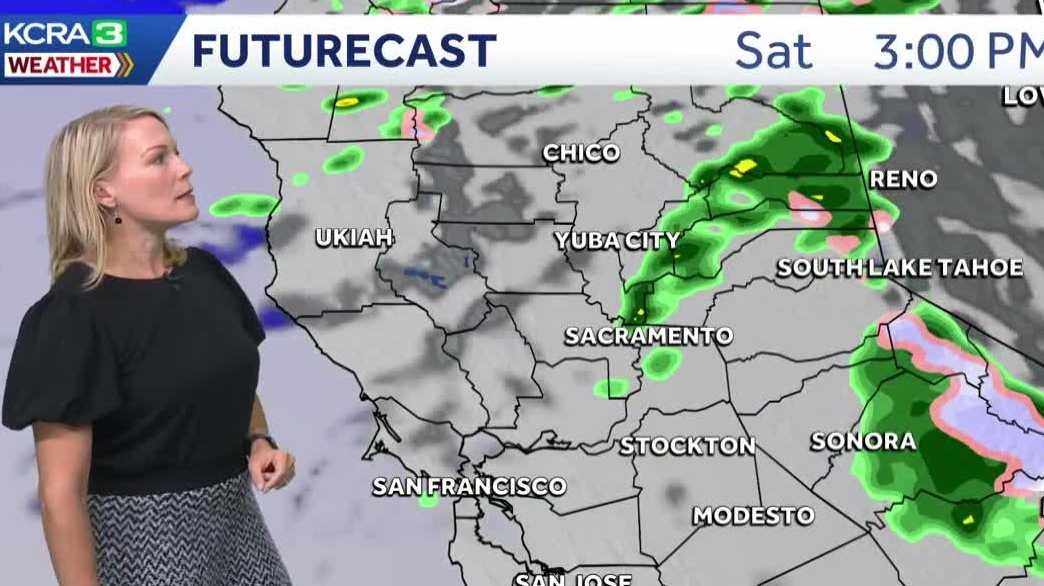
Rain chances go back up this weekend as a storm system moves into the Pacific Northwest. A weakening cold front will pass over Northern California on Saturday, with a few lingering shower chances Sunday.
Below are the forecast rain total ranges for the weekend as of 6 a.m. on Oct. 23, 2025. These numbers are preliminary and could change:
Sacramento — Trace to 0.10 inchStockton — Trace to 0.05 inchModesto — Trace to 0.05 inchYuba City — 0.05 to 0.20 inchAuburn — 0.25 to 0.50 inchPlacerville — 0.20 to 0.30 inchTruckee — 0.10 to 0.25 inchSouth Lake Tahoe — 0.20 to 0.30 inchSonora — 0.10 to 0.20 inch

This weekend system will not bring much cold air to Northern California. That will keep the snow level above the passes Saturday. Donner and Echo Summit will be wet and chilly, but chain controls are not expected.
REAL-TIME TRAFFIC MAP
Click here to see our interactive traffic map.
TRACK INTERACTIVE, DOPPLER RADAR
Click here to see our interactive radar.
DOWNLOAD OUR APP FOR THE LATEST
Here is where you can download our app.
Follow our KCRA weather team on social media
Meteorologist Tamara Berg on Facebook and X.Meteorologist Dirk Verdoorn on FacebookMeteorologist Heather Waldman on Facebook and X.Meteorologist Kelly Curran on X.Meteorologist Ophelia Young on Facebook and X.
Watch our forecasts on TV or online
Here’s where to find our latest video forecast. You can also watch a livestream of our latest newscast here. The banner on our website turns red when we’re live.
We’re also streaming on the Very Local app for Roku, Apple TV or Amazon Fire TV.
See more coverage of top California stories here | Download our app | Subscribe to our morning newsletter | Find us on YouTube here and subscribe to our channel