
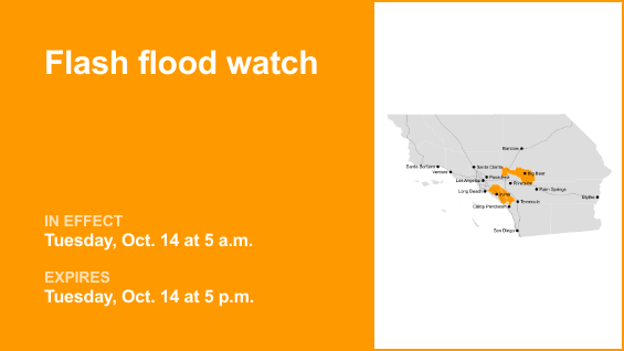
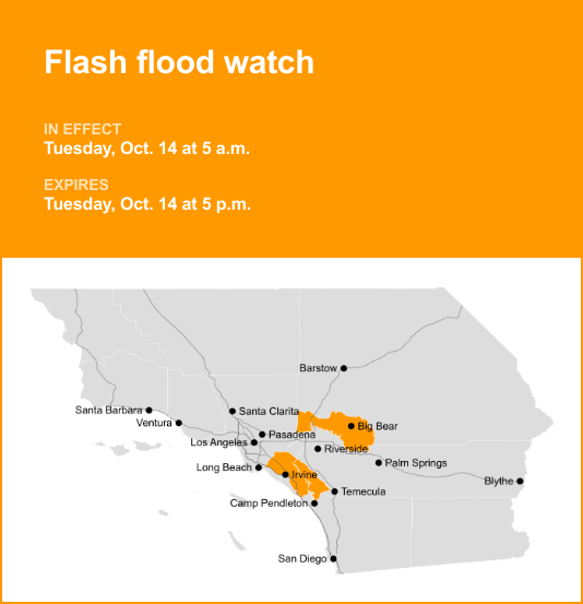
Santa Ana Mountains/Foothills, Orange County and San Bernardino County Mountains are under a flash flood watch which was issued by the National Weather Service on Monday at 2:15 a.m. The watch is valid for Tuesday, Oct. 14 between 5 a.m. and 5 p.m.
According to the NWS San Diego CA, “Flash flooding and debris flows caused by excessive rainfall are possible over the Bridge, Line, Apple, El Dorado and Airport burn scars.”
“Heavy rainfall over the Bridge, Line, Apple, El Dorado and Airport burn scars. Rainfall rates of 0.30 to 0.70 inch per hour are expected up to and during the period of the watch. Residents near the Bridge, Line, Apple, El Dorado and Airport burn scar should prepare for potential flooding impacts. Be sure to stay up to date with information from local authorities. Heavy rainfall could trigger flash flooding of low-lying areas, urbanized street flooding, and debris flows in and near recent wildfire burn scars,” the NWS said. “You should monitor later forecasts and be prepared to take action should Flash Flood Warnings be issued.”
Deciphering advisories, watches, and warnings: Understanding weather alerts
Flash flood warning: Take action!
A flash flood warning is issued when a flash flood is either imminent or already occurring. In flood-prone areas, it’s crucial to move immediately to higher ground. A flash flood is a sudden and violent inundation that can develop within minutes to hours, and it can even happen in areas not currently experiencing rainfall.
Flood warning: Take action!
A flood warning is declared when flooding is on the verge of happening or is already underway.
Flood advisory: Be aware:
A flood advisory is issued when flooding is not expected to be bad enough to issue a warning. However, it may cause significant inconvenience, and if caution is not exercised, it could lead to situations that may threaten life and/or property.
Flood watch: Be prepared:
A flood watch is issued when conditions are favorable for flooding. It does not mean flooding will occur, but it is possible.
Be flood-ready: Expert guidance from the NWS for your safety
Floods can pose a significant threat, especially if you live in a flood-prone area or find yourself camping in a low-lying region. To ensure your safety, the NWS offers essential flood safety guidelines:
Seek higher ground:
If you’re in a flood-prone area, or if you’re camping in a low-lying spot, move to higher ground as a first step.
Follow evacuation orders:
When local authorities issue an evacuation order, promptly comply. Before leaving, secure your home by locking it.
Disconnect utilities and appliances:
If time allows, disconnect your utilities and appliances. This reduces the risk of electrical hazards during flooding.
Steer clear of flooded basements and submerged areas:
Avoid basements or rooms submerged in water with electrical outlets or cords. Preventing electrical accidents is crucial.
Swift evacuation for your safety:
If you notice sparks or hear buzzing, crackling, snapping, or popping sounds, evacuate without delay. Do not enter water that may carry an electrical charge.
Stay away from floodwaters:
Never attempt to walk through floodwaters. Even just 6 inches of swiftly moving water can forcefully knock you off your feet.
Seek higher ground when trapped:
In the event you become trapped by moving water, make your way to the highest point available and contact emergency services by calling 911.
During heavy rain, flooding is possible, especially in low-lying and flood-prone areas. Never drive through water on the road, even if it does not appear to be deep. It takes just 12 inches of rushing water to carry away most cars, according to the NWS. Stay safe by being prepared and informed.
Navigating rainy roads: Safety tips for wet weather
Heavy rainfall may lead to flooding if prolonged or if there is excessive runoff. Excessive runoff can be a result of saturated ground and/or rainfall intensity. Follow these recommendations from the NWS to stay safe in heavy rain:
Beware of swollen waterways:
Avoid parking or walking in close proximity to culverts or drainage ditches, as the swiftly moving water during heavy rain can potentially carry you away.
Maintain safe driving distances:
Use the two-second rule to maintain a safe distance from the car in front of you and allow an extra two seconds in heavy rain.
Slow down and drive with care:
If it is raining and the roads are wet, slow down. Take your foot off the accelerator and let your speed drop gradually. Never use the brakes suddenly because this may cause the car to skid.
Choose your lane wisely:
Stick to the middle lanes to minimize the risk of hydroplaning. Outer lanes are more prone to accumulating water.
Visibility matters:
Turn on your headlights and be careful of other vehicles to the rear and in blind spot areas as they are especially difficult to see through rain-spattered windows.
Watch out for slippery roads:
The first half-hour of rain is when roads are slickest due to a mix of rain, grime, and oil. Exercise heightened caution during this period.
Keep a safe distance from large vehicles:
Large trucks and buses can reduce your visibility with tire spray. Avoid tailgating and pass with caution.
Mind your windshield wipers:
Overloaded wiper blades can hinder visibility. If rain severely impairs your vision, pull over and wait for conditions to improve. Seek refuge at rest areas or sheltered spots.
If the roadside is your only option, pull off as far as possible, preferably past the end of a guard rail, and wait until the storm passes. Keep your headlights on and turn on emergency flashers to alert other drivers of your position.
In the face of heavy rain, these precautions can make a significant difference in ensuring your safety on the road. Remember to stay informed about weather conditions and heed guidance from local authorities for a secure journey.
Originally Published: October 13, 2025 at 2:21 AM PDT