
Northern California forecast: Sunny and mild Tuesday, but unsettled weather returns Wednesday
Pleasant weather is expected Tuesday, but a fast moving system will bring a shot of rain and Sierra snow on Wednesday.
THANK YOU MELANIE. APPRECIATE IT. LET’S GO TO METEOROLOGIST TAMARA BERG. YOU WERE TALKING ABOUT THIS YESTERDAY. YEAH. AND REALLY GREAT SIGHT TO SEE IN THE GREAT THINGS THE WEATHER REALLY COOPERATING NICELY. THE SKIES HAVE BEEN CRYSTAL CLEAR. AND THE BETTER THAT YOU GET AWAY FROM ANY KIND OF LIGHT POLLUTION OR AWAY FROM THE CITY, LIGHTING IS THE BETTER VIEW YOU’RE GOING TO HAVE OF NOT ONLY THE BLOOD MOON, BUT THE FULL MOON IS IN EFFECT RIGHT NOW AS IT ACTUALLY OFFICIALLY PEAKED AT 337 THIS MORNING. AND THEN OF COURSE, AROUND THAT 3:00 HOUR, YOU DID SEE THE COPPER KIND OF LOOK TO THE MOON, AND YOU CAN STILL CATCH A LITTLE GLIMPSE OF IT THIS MORNING AS WELL. TEO JUST WALKED OUTSIDE TO CHECK IT OUT. HERE’S A LIVE LOOK FROM WEST SACRAMENTO. THE CLEAR SKY HERE OVER WEST SAC FROM THE SUTTER HEALTH BALLPARK. TEMPERATURES ARE COOL, SO YOU WANT TO GRAB A LAYER. YOU SEE, MELANIE WAS IN HER JACKET THIS MORNING. THAT’S THE WAY TO GO. WE’RE IN THE MID TO UPPER 40S IN THE VALLEY, ABOUT 51 MODESTO 26. CURRENTLY IN SOUTH LAKE. AND FOR YOUR THIRD DAY OF MARCH, IT IS GOING TO BE WARMER THAN YESTERDAY EXPECTING A DAYTIME HIGH CLOSE TO 70 DEGREES. THE NORMAL HIGH FOR THIS TIME OF YEAR 65. SO WE ARE GOING TO BE RUNNING A LITTLE BIT ABOVE THE NORMAL AND FOURTH DAY. EXPECT THAT REALLY CLEAR CONDITIONS. AND THEN AS WE GET INTO THE EVENING, A WEATHER SYSTEM WILL BE COMING TOWARDS US AND THAT WILL BRING US AN INCREASE IN CLOUDS BY LATER TONIGHT. SO IT’S NICE THAT WE’VE HAD THAT CELESTIAL TREAT IN THE SKY THIS MORNING, BECAUSE THE SKIES HAVE COOPERATED BY TONIGHT. I COULDN’T GUARANTEE THAT THOSE GUYS WOULD BE CLEAR. WORKING OUR WAY INTO TUESDAY AFTERNOON. BRIGHT SUNSHINE EXPECTED. AND THEN WATCH THOSE CLOUDS START TO WORK IN. AND BY TOMORROW MORNING IT IS GOING TO BE A CLOUDY OVERCAST BEGINNING TO THE DAY. SO DO PLAN FOR THAT. AND THEN ONCE WE GET INTO THE AFTERNOON. THIS IS WHEN YOU’RE GOING TO WANT TO GRAB THE UMBRELLA AND KEEP IT BY YOUR SIDE. WITH SCATTERED SHOWERS THAT WILL EXPECT IN THE VALLEY, IN THE FOOTHILLS, AND EVEN SOME SIERRA SNOW ABOVE 5000FT COULD BE A SLUSHY PAVEMENT UP THERE IN THE SIERRA, ESPECIALLY THE PASSES, AS SOME OF THOSE SNOWFLAKES FLY BY TOMORROW AFTERNOON. ONCE THE SYSTEM KICKS OUT OF HERE, WE’RE LEFT WITH A NORTH BREEZE BEHIND THIS SO THINGS WILL GET A LITTLE BIT GUSTY DURING THE DAY THURSDAY AND FRIDAY, AND THE TEMPERATURES WILL STILL STAY QUITE MILD AND THEN WORKING OUR WAY INTO THE WEEKEND. SUNSHINE FOR SATURDAY AND TEMPERATURES MOVING ON UP. EXPECT THOSE HIGHS INTO THE MID 70S BY THE WEEKEND. THE OTHER THING YOU DON’T WANT TO FORGET ABOUT THIS WEEKEND TEO IS TIME CHANGE. YEP, THAT IS HAPPENING. MAKE SURE THAT YOU SPRING FORWARD. THAT’S THAT LITTLE CLOCK INDICATOR IS SATURDAY NIGHT BEFORE YOU HEAD TO BED AND MAKE SURE THAT YOU KNOW YOU ARE GOING TO, UNFORTUNATELY, LOSE AN HOUR OF SLEEP WHEN YOU SPRING FORWARD. BUT SUNDAY NIGHT, THE SUN IS GOING TO BE OUT UNTIL ABOUT
Northern California forecast: Sunny and mild Tuesday, but unsettled weather returns Wednesday
Pleasant weather is expected Tuesday, but a fast moving system will bring a shot of rain and Sierra snow on Wednesday.

Updated: 5:07 AM PST Mar 3, 2026
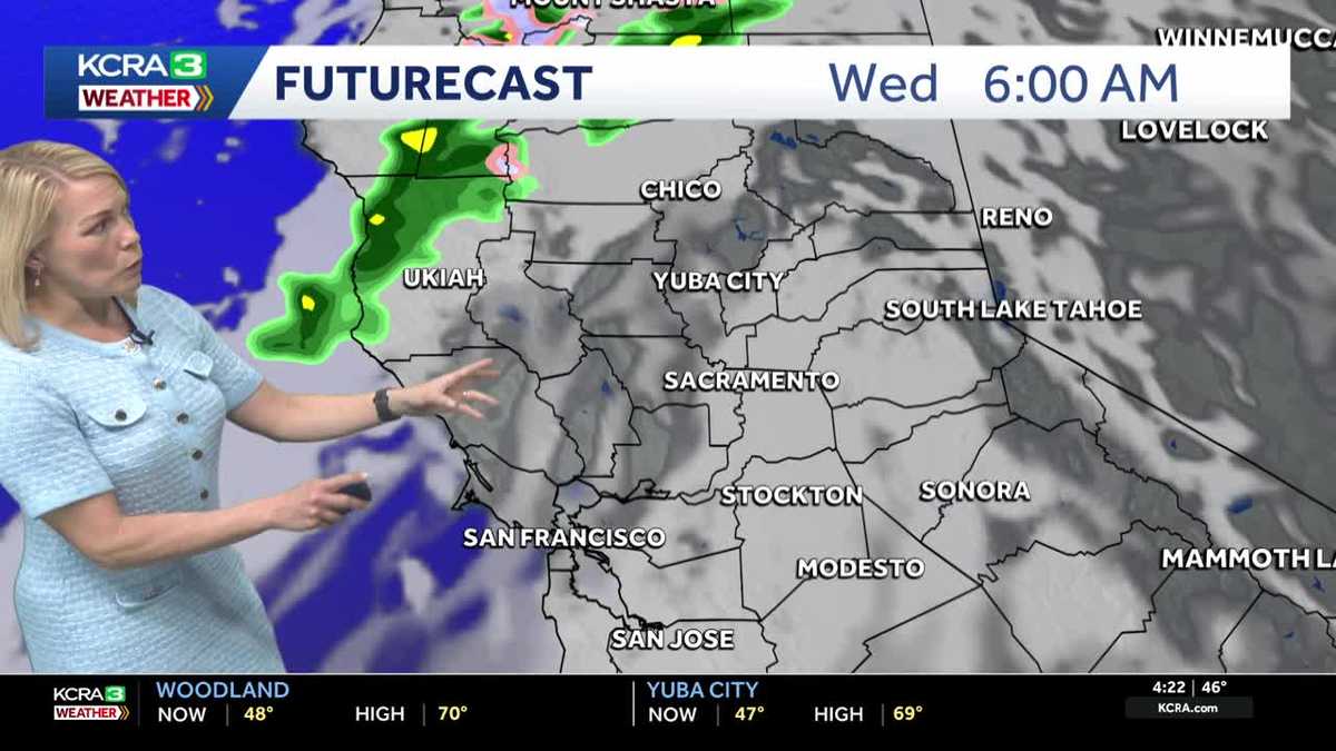
Plan for a cool start to Tuesday under clear skies and light winds. Some patchy fog is possible in the Valley around sunrise. Mostly sunny skies and warmer temperatures are forecast for the afternoon with Valley highs reaching the upper 60s and low 70s. Clouds increase tonight as a weak system moves through on Wednesday. This system will bring some scattered showers and slushy snow. No major impacts are expected. Showers will be hit and miss for the valley and foothills while snow levels in the Sierra will be above 5000’ with only 1-2” expected on the higher peaks. Some isolated thunderstorms are possible Wednesday afternoon.Dry, mild and breezy conditions are forecast for Thursday and Friday.The weekend looks incredibly pleasant with mostly sunny skies and Valley highs in the mid 70s!
SACRAMENTO, Calif. —
Plan for a cool start to Tuesday under clear skies and light winds. Some patchy fog is possible in the Valley around sunrise. Mostly sunny skies and warmer temperatures are forecast for the afternoon with Valley highs reaching the upper 60s and low 70s.
Clouds increase tonight as a weak system moves through on Wednesday. This system will bring some scattered showers and slushy snow. No major impacts are expected. Showers will be hit and miss for the valley and foothills while snow levels in the Sierra will be above 5000’ with only 1-2” expected on the higher peaks. Some isolated thunderstorms are possible Wednesday afternoon.
Dry, mild and breezy conditions are forecast for Thursday and Friday.
The weekend looks incredibly pleasant with mostly sunny skies and Valley highs in the mid 70s!