
Northern California forecast: Calm and very pleasant Sunday
Northerly winds have calmed down, leaving behind a warm rest of the weekend with plenty of sunshine.
WE’RE TAKING A LIVE LOOK IN SACRAMENTO. WE WANT TO CHECK BACK IN WITH OUR METEOROLOGIST, OPHELIA YOUNG, WHO’S TRACKING WHAT WE’RE SEEING ACROSS THE COUNTRY RIGHT NOW. YEAH, WE’RE GOING TO START YOU OFF TO OUR EAST, WHERE A LINE OF SEVERE STORMS DEVELOP YESTERDAY AND SPAWNED A FEW TORNADO OUTBREAKS. TORNADOES BECAME DEADLY IN OKLAHOMA AND MICHIGAN, WHERE REPORTED SIX LIVES HAVE BEEN CLAIMED SO FAR AS THIS LINE OF STORMS CONTINUES THROUGH THE EAST COAST. WE STILL HAVE CONVECTIVE WATCHES IN TEXAS, LOUISIANA AND MISSISSIPPI CURRENTLY BACK OUT WEST. MUCH QUIETER WEATHER. WE’VE HAD A FEW BREEZY, IF NOT WINDY DAYS AS THIS AREA OF LOW PRESSURE SITS OFF TO OUR SOUTH WEST. HOWEVER, THAT’S ABOUT TO CHANGE AS HIGH PRESSURE NOSES INTO OUR REGION OVERHEAD AND NORTH OF THAT LOW TEMPERATURES ARE GOING TO CONTINUE TO BE WARM. BUT THOSE WINDS ARE GOING TO CALM DOWN FOR THE BACK HALF OF YOUR WEEKEND. CURRENTLY, TEMPS RUNNING IN THE MID 70S IN YUBA CITY AND SACRAMENTO, UPPER 60S IN STOCKTON AND MODESTO WHERE THE WINDS ARE A LITTLE QUIETER. YOU SEE THAT PATTERN THERE? THE WINDS ARE OUT TO FAIRFIELD IN SAN FRANCISCO, WHERE TEMPERATURES ARE ALSO IN THE LOW 70S. PLACERVILLE AT 70 DEGREES TRUCKEE AND SOUTH LAKE TAHOE. CLIMBING IN THE UPPER 40S AND LOW 50S TODAY. THE SUN IS SETTING NOW, BUT AT THIS TIME TOMORROW THERE WILL BE MORE SUNSHINE AS DAYLIGHT SAVING TIME BEGINS. SO THE SUN SETS AT 605 THIS EVENING. TOMORROW WILL BE SETTING A LITTLE BIT CLOSER TO 706 IN THE EVENING, AND THAT SUN WILL SET LATER AND LATER EACH DAY UNTIL THE START OF SUMMER, WHICH OFFICIALLY IS JUNE 21ST. BY THEN THE SUN WILL BE SETTING AT 833. ALSO, YOUR MORNINGS WILL BE A LITTLE DARKER. STARTING TOMORROW. YOUR NEW SUNRISE WILL BE 727. THE SUN DOESN’T RISE UNTIL A LITTLE CLOSER TO 730 TOMORROW, SO WE STILL HAVE A LITTLE WIND THAT’S LINGERING. NOW THAT SHOULD CALM DOWN THROUGH THE EVENING. BY THE TIME WE WAKE UP TOMORROW. CALM WINDS AND IT’S GOING TO STAY THAT WAY THROUGH YOUR MONDAY. THE ONLY WINDY DAY THAT I’M LOOKING AT AND I’M TALKING ABOUT WINDS. MAYBE AT ABOUT TEN 15MPH WILL BE TUESDAY, BUT IT WON’T BE ANYTHING LIKE THE WINDS THAT WE’VE SEEN THESE LAST COUPLE OF DAYS. SO THIS NEXT UPCOMING WEEK IS GOING TO BE A QUIET ONE FOR THE MOST PART. AND TEMPERATURES TONIGHT ARE GOING TO BE DIPPING INTO THE 60S. GOING TO BE A REALLY NICE SATURDAY NIGHT LEADING INTO A QUIETER SUNDAY. SIMILAR VALUES LIKE TODAY TEMPERATURE WISE, BUT WE’RE GOING TO ADD A LITTLE MORE SUNSHINE AND WE’RE GOING TO PULL BACK THOSE WINDS. SO REALLY BEAUTIFUL SECOND HALF OF THE WEEKEND AS OUR AREA OF LOW PRESSURE RESPONSIBLE FOR THE WIND LIFTS AWAY, THAT JET STREAM FLATTENS OUT A LITTLE BIT, MIGHT ALLOW A FEW DISTURBANCES TO MOVE THROUGH, WHICH IS WHY WE HAVE THE BREEZES THAT WILL PICK UP AGAIN ON TUESDAY. BUT HIGH PRESSURE RETURNS AT THE END OF THE WEEK, WHICH MEANS TEMPERATURES BY THEN WILL BE RUNNING ABOUT TEN DEGREES ABOVE THE NORMAL, MOSTLY SUNNY SKIES AND OCCASIONAL BREEZES. IT’S REALLY GOING TO FEEL LIKE SPRING NEXT WEEK, AND SPRING DOES NOT OFFICIALLY START FOR ANOTHER TWO WEEKS, SO WE MIGHT GET DOWN TO LOW 70S. TUESDAY. THAT IS STILL WARMER THAN OUR AVERAGE OF THE NORMAL, AND THEN BY THE END OF THE WEEK, WE’RE GOING TO BE FLIRTING WITH THE 80S.
Northern California forecast: Calm and very pleasant Sunday
Northerly winds have calmed down, leaving behind a warm rest of the weekend with plenty of sunshine.

Updated: 5:52 PM PST Mar 7, 2026
SACRAMENTO, Calif. —
Northerly winds have calmed down, leaving behind a warm rest of the weekend with plenty of sunshine.
The rest of the week will be dry with the occasional breeze as forecast highs warm to near-record values.
Forecast highs
Valley high temperatures will be similar to Saturday’s but skies will be sunnier, and winds will be noticeably lighter. The weather will be much warmer in the Sierra however, where forecast highs are in the low 60s.
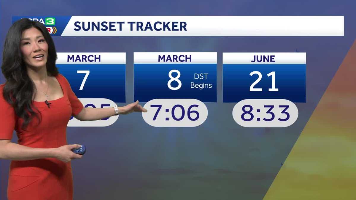
DST begins
Our new sunrise will be 7:28 on Sunday morning. The sun will set at 7:06 pm and will continue to set later each day through the start of Summer which is on June 21st.
Temperature trend
Highs dip slightly the first half of the week as weak disturbances pass. Even then, temperatures will still remain above the normal. High ridges in for the second half of the week and high temperatures soar.
Foothills & Sierra 7-day forecast
Warm weather will be widespread in the Foothills and Sierra, too.
Valley 7-day forecast
Spring-like weather is here to stay for a while in the Valley. There are currently no signs of rain or cooler temperatures for at least the next 7-10 days.