

One of the world’s top seasonal forecast models now puts the odds of a strong El Niño developing by late summer at 80 percent. The odds of at least a moderate event are even higher, around 98 percent, with some models flirting with super El Niño territory by fall.
That’s the latest from the European Centre for Medium-Range Weather Forecasts, which released its updated predictions last week. (A NOAA long-range model output released over the weekend is in agreement.) What’s striking isn’t just the potential strength of the El Niño, but how sharply the forecast confidence increased compared to a month ago.
“Something happened between February and March,” said Shang Ping Xie, a climate scientist at the Scripps Institution of Oceanography. As recently as a month ago, he noted, forecast models showed several possible outcomes. But now, there is a growing consensus that a moderate to strong El Nino will emerge by the end of the summer.
What it could mean for California
Daniel Swain, a climate scientist at the California Institute for Water Resources, pointed to potential impacts that could arrive before winter. A marine heat wave persisting along the California coast and down through Baja California would likely become anchored in place by a rapidly emerging El Niño, he said, keeping coastal waters warmer than average for much of the year.
Bay Area beaches that spent much of last summer socked in by a stubborn marine layer could see warmer, sunnier conditions this year if the El Niño signal holds. Previous studies have shown that warm water phases and increased ocean temperatures that come with El Niño often correlate with reduced coastal fog.
Strong El Niño years also historically tend to bring a more active eastern Pacific hurricane season, increasing the odds that tropical storm remnants reach California before fully dissipating. The 2023 El Niño year helped fuel 10 eastern Pacific hurricanes in 2023, including two Category 5 storms and Hurricane Hilary, which maintained hurricane strength within 200 miles of the California coast.

El Niño typically suppresses vertical wind shear over the eastern Pacific, creating favorable conditions for hurricane development west of Mexico while reducing activity in the Atlantic. (NOAA Climate.gov) (NOAA)
What’s driving the signal
The shift to a probable, and potentially strong, El Niño, has been driven in part by a series of unusually strong westerly wind bursts along the equator beginning in January. Some forecasters described it as the biggest mid-winter collapse of La Niña in two decades. These bursts temporarily overwhelmed the trade winds that sustain the current La Niña, allowing warm water that had been pooled in the western Pacific to surge eastward.
Each burst matters because of what it does both at the surface and below. Subsurface ocean temperatures are running nearly 6 degrees above normal in some parts of the Central Pacific. That gives the emerging El Nino pattern some staying power.
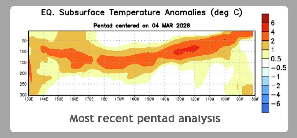
Equatorial subsurface ocean temperatures as of early March 2026 show anomalies of 4 to 6 degrees Celsius above normal at depths of 100 to 150 meters across much of the central and eastern Pacific. (NOAA CPC) (NOAA)
Paul Roundy, an atmospheric scientist at the University at Albany who studies tropical Pacific dynamics, also explained that the structure of these bursts is in line with producing the kind of east Pacific-centered El Niño associated with the most historically impactful events.
“When the westerly winds aren’t so focused on the equator, the resulting oceanic waves tend to fail to warm the central Pacific much, contributing most of their warming near the coast of South America,” Roundy said in an email. “In those cases the warm anomalies develop near the coast and then expand westward.” The Chilean Meteorological Agency has already declared this warming to be underway.
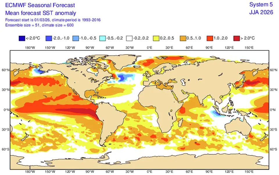
The ECMWF seasonal forecast projects widespread sea surface temperature anomalies of 1 to 2 degrees Celsius above normal across the tropical Pacific by summer 2026, with the strongest warming concentrated along the South American coast – a signature of a classic east Pacific El Niño. (ECMWF) (ECMWF )
That pattern points toward a classic eastern-Pacific El Niño, the structure associated with two of the strongest El Niños on record in 1982-83 and 1997-98.
Why the forecast confidence is higher and what could still go wrong
Part of what separates this outlook from prior near-misses is the model doing the forecasting. Roundy noted in an email that ECMWF is the best model in the world and that its latest forecast is now capturing recent Pacific Ocean temperatures and wind observations in ways that help penetrate the spring predictability barrier, a window each year when tropical Pacific forecasts are inherently less reliable.
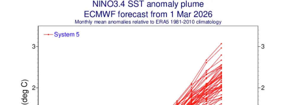
The ECMWF SEAS5 seasonal forecast, initialized March 1, shows 51 model runs converging sharply toward moderate to strong El Niño conditions by late summer 2026. (ECMWF) (ECMWF )
A 2014 false start remains the cautionary reference point. The Pacific looked similar that spring, but westerly wind bursts ceased in April and the anticipated El Niño fizzled, delaying its arrival by a full year. “In 2014 we were in a similar situation in March, but the westerly wind events ceased in April. This is why some caution remains merited,” said Roundy. “The next four to six weeks will be important to watch.”
‘It’s a crapshoot’
Not everyone sees the signal as story-worthy yet. Jan Null, a California-focused meteorologist and longtime ENSO analyst, pushed back on the forecast confidence and on what even a strong El Niño would mean for the state.
“We’ve had three previous major warming events in ’82, ’97, great big very wet years in California. 2014 was supposed to be the same, but it was a bust,” Null said. “All the past correlations that worked so well in predicting El Niño in the 80s and 90s are gone. It’s a crapshoot.”
Studies have shown that a fast-warming ocean has changed the rulebook on what impacts are to be expected from El Niño and La Niña. It resulted in NOAA recently updating its ENSO classification system to account for global warming.
On the increased model confidence of a major event, Null was equally skeptical. “I have not seen the model skill in the past be so reliable this far out ” he said. “I wouldn’t reach in my wallet and pull out 20 bucks to bet on it.”
Xie echoed the caution on one specific California impact. He noted that the data linking El Niño directly to tropical storms reaching the California coast is too limited to say either way.
What comes next
NOAA’s Climate Prediction Center is expected to release its updated March ENSO outlook later this week, and other global modeling centers will follow. NOAA currently places El Niño development at 50 to 60 percent probability for late summer and fall.
Swain, for his part, offered a carefully calibrated bottom line after reviewing the full picture. “The most likely outcome is a significant El Niño event for the summer – that’s a very high confidence statement,” he said. “And there are early but tentative signs that it could be a particularly strong one.”
This article originally published at Odds of strong El Niño surge – and potential California impacts become clearer.