
TODAY. SO WE’LL KEEP AN EYE IN THE PLAINS IN THE MIDWEST. MEANWHILE, IN THE WEST COAST AGAIN, BRACING OURSELVES FOR THE HEAT HERE ARE FORECAST HIGHS IN THE DESERT SOUTHWEST THIS WEEKEND. LAS VEGAS AND PHOENIX WARMING INTO THE 80S AND THE 90S. CHECK OUT NEXT WEEK WHEN PHOENIX IS EXPECTED TO CLIMB INTO THE TRIPLE DIGIT TERRITORY FOR THE FIRST TIME THIS YEAR AND BEYOND BY THE END OF NEXT WEEK. AND THAT DOES MEAN SACRAMENTO. LOOKING AT ABNORMALLY WARM WEATHER, TOO, WITH FORECAST HIGHS IN THE 80S NEXT WEEK. SO SOAK IN THE COOLER WEATHER WHILE YOU CAN, ESPECIALLY THIS MORNING WITH TEMPERATURES CURRENTLY RUNNING IN THE UPPER 40S IN SACRAMENTO AND STOCKTON. WE HAVE LOW 50S IN YUBA CITY AND MODESTO AUBURN AT 54 DEGREES TRUCKEE AND SOUTH LAKE TAHOE DEPENDING ON WHERE EITHER THE 20S OR THE 40. SO TEMPERATURES ARE A LITTLE BIT ERRATIC. SO ARE THE WINDS. WE HAVE A BREEZE THROUGH FAIRFIELD AND ALSO A BREEZE THROUGH SOUTH LAKE TAHOE. THAT ONSHORE WIND ENHANCE THIS MORNING THANKS TO THAT JET STREAM THAT’S DROPPING SOUTH. IN FACT, DROPPING OFF A FEW FLAKES OF SNOW IN THE HILLS OF SHASTA, LASSEN AND PLUMAS COUNTIES LOOKS LIKE THAT’S NOT LASTING LONG. WE HAVE HIGH PRESSURE GETTING READY TO MOVE IN FOR THE REST OF THE WEEK, AND THIS IS WHAT’S GOING TO DRAG THOSE TEMPERATURES UP INTO NEAR RECORD TERRITORY BY THE END OF THIS WEEK. SO WE’LL BE IN THE MID TO UPPER 70S ALREADY ABOVE AVERAGE TODAY. WE’RE GOING TO BE FAR ABOVE THAT BY THE END OF THIS WEEK WITH TEMPERATURES CLIMBING INTO THE LOW 80S FOR THE FIRST TIME THIS YEAR AND AGAIN APPROACHING THOSE DAILY RECORD HIGHS, WE HAVE HEAT RISK THAT IS GOING TO SPREAD ACROSS THE ENTIRE NORTHERN CALIFORNIA REGION, LEADING INTO THE FOOTHILLS AND THE SIERRA. BY THE END OF THIS WEEK. AND THE FOOTHILLS, THAT DOES MEAN TEMPERATURES THIS WEEKEND IN THE MID 60S
Northern California forecast: Slightly cooler Tuesday, but abnormal warmth likely to continue

Updated: 7:04 AM PDT Mar 10, 2026
Temperatures will slightly dip Tuesday for Northern California ahead of a warming trend bringing above-average heat to the region. Meteorologist Ophelia Young said Tuesday’s forecast high for downtown Sacramento is 72 degrees. The average for this time of year is 66 degrees.Highs in the Foothills could reach the upper 60s, while peak temperatures in the Sierra could reach the mid-50s.While Tuesday is expected to be slightly cooler in comparison to Monday, the region is likely to see warmer temperatures for the rest of the week as a high-pressure system moves in.The first 80-degree day of the year for the Sacramento area may come as early as this Saturday.Young said temperatures may continue to scale upward next week.REAL-TIME TRAFFIC MAPClick here to see our interactive traffic map.TRACK INTERACTIVE, DOPPLER RADARClick here to see our interactive radar.DOWNLOAD OUR APP FOR THE LATESTHere is where you can download our app.Follow our KCRA weather team on social mediaMeteorologist Tamara Berg on Facebook and X.Meteorologist Dirk Verdoorn on FacebookMeteorologist/Climate Reporter Heather Waldman on Facebook and X.Meteorologist Kelly Curran on X.Meteorologist Ophelia Young on Facebook and X.Watch our forecasts on TV or onlineHere’s where to find our latest video forecast. You can also watch a livestream of our latest newscast here. The banner on our website turns red when we’re live.We’re also streaming on the Very Local app for Roku, Apple TV or Amazon Fire TV.See more coverage of top California stories here | Download our app | Subscribe to our morning newsletter | Find us on YouTube here and subscribe to our channel
SACRAMENTO, Calif. —
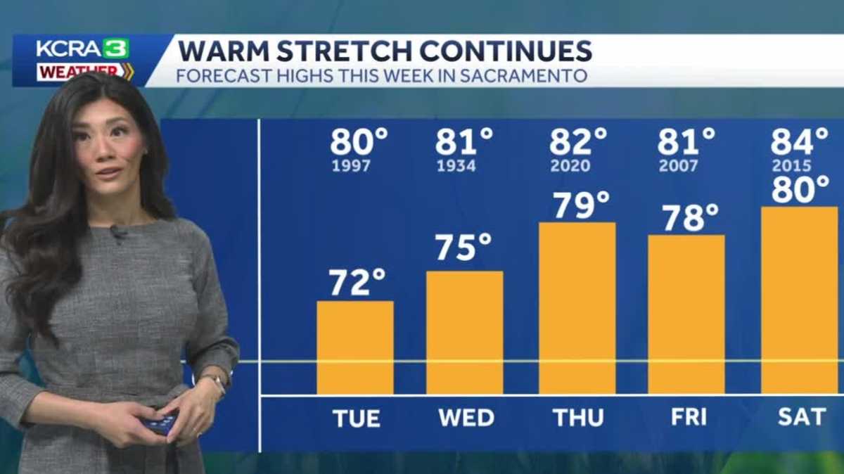
Temperatures will slightly dip Tuesday for Northern California ahead of a warming trend bringing above-average heat to the region.
Meteorologist Ophelia Young said Tuesday’s forecast high for downtown Sacramento is 72 degrees. The average for this time of year is 66 degrees.
Highs in the Foothills could reach the upper 60s, while peak temperatures in the Sierra could reach the mid-50s.
While Tuesday is expected to be slightly cooler in comparison to Monday, the region is likely to see warmer temperatures for the rest of the week as a high-pressure system moves in.
The first 80-degree day of the year for the Sacramento area may come as early as this Saturday.
Young said temperatures may continue to scale upward next week.
REAL-TIME TRAFFIC MAP
Click here to see our interactive traffic map.
TRACK INTERACTIVE, DOPPLER RADAR
Click here to see our interactive radar.
DOWNLOAD OUR APP FOR THE LATEST
Here is where you can download our app.
Follow our KCRA weather team on social media
Meteorologist Tamara Berg on Facebook and X.Meteorologist Dirk Verdoorn on FacebookMeteorologist/Climate Reporter Heather Waldman on Facebook and X.Meteorologist Kelly Curran on X.Meteorologist Ophelia Young on Facebook and X.
Watch our forecasts on TV or online
Here’s where to find our latest video forecast. You can also watch a livestream of our latest newscast here. The banner on our website turns red when we’re live.
We’re also streaming on the Very Local app for Roku, Apple TV or Amazon Fire TV.
See more coverage of top California stories here | Download our app | Subscribe to our morning newsletter | Find us on YouTube here and subscribe to our channel