
Northern California forecast: Increasing clouds on this Friday ahead of weekend showers
Aside from overcast skies, Friday will be dry and comfortable.
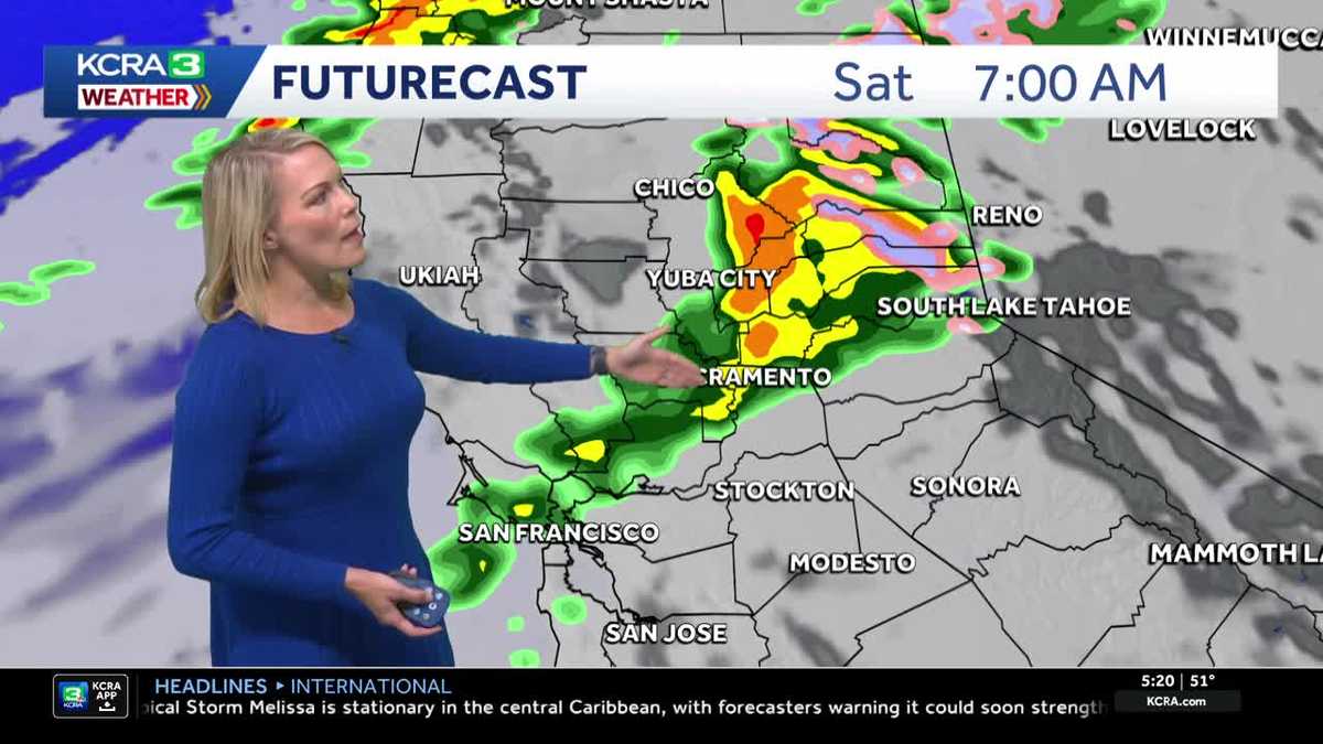
TIME NOW IS 519. LET’S TURN OUR ATTENTION TO KCRA 3 WEATHER. AND AGAIN, REALLY ANOTHER NICE START. SEE CAN KIND OF ENJOY IT TODAY. IT IS. YEAH. BUT IF YOU ARE DRIVING THROUGH SOME OF THE FOG THAT COULD BE A LITTLE TOUGH, ESPECIALLY AS WE GET CLOSER TO DAYBREAK. THAT’S WHEN THE FOG GETS A LITTLE BIT THICKER. PRIMARILY RIGHT NOW IN STOCKTON, YOU’VE GOT A NICE KICKOFF TO THE DAY, YOU’VE GOT SOME HAZY SKIES AROUND TOWN. THIS VANTAGE POINT COMING TO US FROM THE SOUTH ARENA. SKY CAMERA! LOOK AT THESE UNIFORM TEMPERATURES. IT’S 51. WHETHER YOU’RE JOINING US IN SACRAMENTO STOCKTON MODESTO AREA. IT IS 30 RIGHT NOW IN SOUTH LAKE TAHOE. AND LET’S TALK ABOUT THE FOG BECAUSE THIS VISIBILITY JUST DROPPED OFF WITHIN ABOUT THE LAST 20 MINUTES. SACRAMENTO NOW DOWN TO ABOUT LESS THAN A MILE. AND THAT’S RIGHT AROUND THE EXECUTIVE AIRPORT IN THE SOUTH SIDE HERE OF SACRAMENTO AND ALONG PART OF THE RIVERBED THERE, AS YOU DRIVE ALONG THE AMERICAN RIVER THIS MORNING, FIVE MILE VISIBILITY IN STOCKTON. NOT TOO BAD. SAME STORY IN MODESTO. WE DO HAVE SOME HAZY SKIES AS YOU GET WEST OF FAIRFIELD, AND SEEING SOME HEAVIER FOG IN AREAS LIKE SONOMA COUNTY WEATHER SYSTEM ON THE MOVE. AND AS IT TRACKS INTO OUR AREA STARTING TOMORROW MORNING, THAT’S WHEN WE’RE GOING TO SEE OUR BEST SHOT AT RAIN CHANCES. SO IF YOU’RE WONDERING ABOUT YOUR FRIDAY, WE’RE GOING TO STAY DRY. IT’S GOING TO BE GOOD FOR KIDS THAT HAVE GAMES INTO THE EVENING. JV VARSITY FOOTBALL GAMES, OR IF YOU HAVE AN OUTDOOR PLAN OR YOUR KIDS HAVE AFTER SCHOOL ACTIVITIES, YOU’RE IN GOOD SHAPE. THE CLOUDS WILL THICKEN UP THOUGH AS WE HEAD THROUGH THE OVERNIGHT. AND THEN HERE’S OUR SHOT AT THAT RAIN COULD SEE SOME LIGHT TO MODERATE BANDS OF RAIN PUSH THROUGH THE AREA, THIS MODEL AT LEAST INDICATING A BIT MORE MODERATE RAIN, ESPECIALLY UP IN THROUGH YUBA CITY, MARYSVILLE AND UP INTO PLUMAS COUNTY. FIRST THING TOMORROW MORNING WE GET BEYOND ABOUT 9:00. SHOWERS WILL START TO PUSH INTO THE FOOTHILLS AND IT’S JUST GOING TO BE A SOGGY DAY TOMORROW IN THE FOOTHILLS WITH THOSE SNOW SHOWERS PRIMARILY ABOVE 8000FT. NOW THAT SNOW LEVEL DROPS DOWN A BIT MORE AS WE GET INTO SUNDAY, ESPECIALLY AROUND 7 A.M., WE COULD SEE SNOW RIGHT AROUND 7000FT, SO WE MAY SEE A DUSTING, POSSIBLY AT SOME OF THE PASSES, BUT I’M NOT EXPECTING ANY ACCUMULATING SNOW AT THE PASS LEVEL. OCCASIONAL SHOWERS DURING THE DAY ON SUNDAY, SO JUST THE TYPE OF RAIN THAT WE’RE GOING TO BE DODGING THOSE DROPS HIT AND MISS AGAIN. IT’S NOT GOING TO BE AN OVERLY SOAKER OF A WEEKEND, BUT WHEN YOU GET UNDERNEATH SOME OF THESE SHOWERS, THEY COULD PRODUCE ANYWHERE FROM A 10TH TO MAYBE 3/10 IN THE FOOTHILLS, A BIT BETTER IN THE SIERRA, WE COULD SEE UP TO ABOUT A HALF AN INCH OF RAINFALL AGAIN, AND THAT’S THE TWO DAYS COMBINED. SO SATURDAY AND SUNDAY ARE SOME OF THOSE ACCUMULATION TOTALS. SHOWERS AHEAD FOR SATURDAY AND SUNDAY. AND THEN WE GET INTO SUNDAY NIGHT. WE CLEAR OUT MONDAY AND INTO NEXT WEEK GUYS. WE DO START TO WARM, BUT NOTICE THERE’S JUST A LOT OF 70S IN THE FORECAST FOR NEXT WEEK, WHICH IS PRETTY IDEAL FOR THE E
Northern California forecast: Increasing clouds on this Friday ahead of weekend showers
Aside from overcast skies, Friday will be dry and comfortable.

Updated: 6:19 AM PDT Oct 24, 2025
Aside from overcast skies, Friday will be dry and comfortable.Clouds will push in this morning. Expect valley highs in the mid-70s, foothill highs in the low 70s, and Sierra highs in the mid-60s. An afternoon breeze is likely.Conditions are becoming increasingly unsettled as an atmospheric river moves across the Pacific Northwest, with Northern California catching the tail end of this moisture.Our first chance of rain arrives early Saturday, turning into a few showers through Saturday morning and early afternoon. Breezes and cooler air will accompany the wet weather, with valley highs dropping to the mid-60s for the weekend.There will be a dry but cloudy window Saturday evening and night, but a few post-frontal showers may be intermittent through Sunday. Storm totals in the valley will be meager—up to a tenth of an inch—but higher amounts are expected north of Sacramento and toward the Sierra. Spots like Yuba City may receive up to a quarter-inch, and the Sierra should prepare for up to a half-inch, with snow levels dropping to around 7,000 feet Sunday morning.Conditions begin to dry out Sunday evening, and the rest of next week looks mild and dry.
SACRAMENTO, Calif. —
Aside from overcast skies, Friday will be dry and comfortable.
Clouds will push in this morning. Expect valley highs in the mid-70s, foothill highs in the low 70s, and Sierra highs in the mid-60s. An afternoon breeze is likely.
Conditions are becoming increasingly unsettled as an atmospheric river moves across the Pacific Northwest, with Northern California catching the tail end of this moisture.
Our first chance of rain arrives early Saturday, turning into a few showers through Saturday morning and early afternoon. Breezes and cooler air will accompany the wet weather, with valley highs dropping to the mid-60s for the weekend.
There will be a dry but cloudy window Saturday evening and night, but a few post-frontal showers may be intermittent through Sunday. Storm totals in the valley will be meager—up to a tenth of an inch—but higher amounts are expected north of Sacramento and toward the Sierra. Spots like Yuba City may receive up to a quarter-inch, and the Sierra should prepare for up to a half-inch, with snow levels dropping to around 7,000 feet Sunday morning.
Conditions begin to dry out Sunday evening, and the rest of next week looks mild and dry.