
Unseasonably warm weekend across Northern California
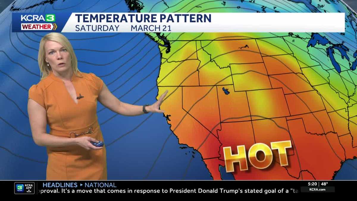
WE TALK A LOT ABOUT THE WARM UP, TAMARA, THAT WE’RE EXPECTING, BUT THERE IS A WINDOW DURING THE MORNING TIME TO REALLY JUST GET OUTSIDE AND DO SOME ERRANDS. FEEL LIKE I’VE SLID INTO JUNE, ALL OF US, I’M TELLING YOU. OKAY, PLAN YOUR DAY AROUND DOING THINGS OUTSIDE WHEN IT’S COMFORTABLE, ESPECIALLY STRENUOUS EXERCISE. I FEEL LIKE PEOPLE ARE GOING TO THINK WE DRESS IN THE SAME EXACT COLOR ON PURPOSE. I THINK. YOU KNOW WHAT? DID YOU SEND ME A MEMO YESTERDAY? MAYBE MAYBE, MAYBE I JUST WANT TO TAKE THAT OFF THE TABLE. YEAH, EXACTLY. IT’S EXACTLY THE SAME. TOTAL COINCIDENCE. WE’RE CHANNELING EACH OTHER. ALL RIGHT, THE FORECAST. HERE’S A LIVE LOOK OUTSIDE IN DOWNTOWN WHERE THE SKIES ARE IN GENERAL, MOSTLY CLEAR. IT’S 48 DEGREES CURRENTLY IN THE CAPITAL CITY, 46 OUT THE DOOR. STOCKTON 49 FOR YOU. MODESTO. AND CURRENTLY 27 SOUTH LAKE TAHOE. TODAY IT IS THE 13TH DAY OF MARCH. IT’S ALSO A FRIDAY. YOU CAN PUT TWO AND TWO TOGETHER. TEMPERATURES MOVING INTO THE UPPER 70S BY THE AFTERNOON DOWN A HAIR FROM YESTERDAY. WE’RE STILL RUNNING WELL ABOVE NORMAL THOUGH WITH NORMAL 66. THE RECORD ON THIS DAY IS 81. WE’RE GOING TO STAY AWAY FROM IT. AT LEAST TODAY. WE’RE PROBABLY GOING TO STAY AWAY FROM IT AGAIN TOMORROW. BUT SUNDAY WE REALLY START TO SEE THE JOG UPWARD. SO THE FORECAST FOR SATURDAY, VERY SIMILAR FEEL TO TODAY WITH MAYBE A LITTLE LESS CLOUD COVER. FOOTHILLS MID 70S FOR SATURDAY, LOW 60S IN THE SIERRA. AND THEN WE ALL START TO FEEL THE WARMTH BUILDING BY SUNDAY. WHAT YOU’LL NOTICE ABOUT THE FORECAST IS WE’VE GOT A BIG AREA OF HIGH PRESSURE BUILDING HERE ALONG THE EASTERN PACIFIC, WHILE YOU CAN ALSO SEE A BIG RIVER OF MOISTURE IN THAT SKY. TRACKING ACROSS THE PACIFIC NORTHWEST THAT’S PROVIDING SOME RAIN AND SNOW. THAT IS AN ATMOSPHERIC RIVER HITTING THE PACIFIC NORTHWEST DURING THE WEEKEND. NOW FOR US, UNDERNEATH THIS RIDGE OF HIGH PRESSURE, THE BUILDING OF THE HEAT CONTINUES. SUNDAY FORECAST HIGH 82. WE’LL MAKE THE JOG TO THE MID 80S BY MONDAY. UPPER 80S PUSHING CLOSE TO 90 BY THE END OF NEXT WEEK. NOW, IF ALL OF THESE NUMBERS DO COME TO FRUITION, WE WILL BREAK RECORDS SUNDAY ALL THE WAY THROUGH THURSDAY. SO THIS BIG AREA OF HIGH PRESSURE CONTINUES TO BUILD AND IT JUST SITS AROUND HERE AS WE GET INTO WEDNESDAY AND EVEN INTO THURSDAY, THURSDAY, WE COULD SEE THE PEAK OF THE HEAT. BUT THEN AS WE LOOK DOWN THE ROAD INTO THE NEXT WEEKEND, LOOKING AHEAD TO THE 21ST OF MARCH, WE COULD START TO SEE SOME COOLER AIR START TO MOVE IN. SO AGAIN, HOT WEATHER EXPECTED NEXT COUPLE OF DAYS. TALKING UPPER 70S SUNDAY IN THE FOOTHILLS MID 60S IN THE SIERRA AND 70S. BY NEXT WEEK, YOUR SEVEN DAY FORECAST AGAIN, YOU SEE THOSE NUMBERS? THOSE AREN’T TYPOS. UPPER 70S STRAIGHT THROUGH SATURDAY. AND THEN BYE BYE 70S INTO THE 80S BY SUNDAY AND TRACKING CLOSE TO 90 BY THURSDAY. IT IS HARD TO BELIEVE THAT THIS IS MIDDLE OF MARCH AND WE FEEL THIS HEAT. THERE’S AREAS IN THE DESERT OF SOUTHERN CALIFORNIA COULD. IN 100. I KNOW I WAS LOOKING AT ARIZONA’S GOT THIS HEAT WAVE GOING
KCRA Meteorologist Tamara Berg details how warm the weekend will get and when there’s potential for record-breaking heat.Friday will be very warm as highs across the region peak in the mid 70s to low 80s. Expect to see some clouds dim the sunshine as a system sweeps by to the North. Brighter skies ahead for Saturday with temps warming again. Valley highs peak in the upper 70s. Record-breaking heat possible starting on SundayWarmer days coming by Sunday and into the following work week. High temperatures expected to soar 20 degrees above normal through the week. Many records are likely to fall. Take a look at the Sacramento forecast vs. records below. Forecast RecordSunday 3/15 82 82 (2007)Monday 3/16 85 83 (2007Tuesday 3/17 87 83 (1972)Wednesday 3/18 88 82 (2004)Thursday 3/19 89 81 (2015)The unseasonably warm days looks to hold through the work week. Forecast models trending towards potential for cooling and a return to seasonable weather by next weekend.
KCRA Meteorologist Tamara Berg details how warm the weekend will get and when there’s potential for record-breaking heat.
Friday will be very warm as highs across the region peak in the mid 70s to low 80s. Expect to see some clouds dim the sunshine as a system sweeps by to the North.
Brighter skies ahead for Saturday with temps warming again. Valley highs peak in the upper 70s.
Record-breaking heat possible starting on Sunday
Warmer days coming by Sunday and into the following work week. High temperatures expected to soar 20 degrees above normal through the week.
Many records are likely to fall. Take a look at the Sacramento forecast vs. records below.
Forecast Record
Sunday 3/15 82 82 (2007)
Monday 3/16 85 83 (2007
Tuesday 3/17 87 83 (1972)
Wednesday 3/18 88 82 (2004)
Thursday 3/19 89 81 (2015)
The unseasonably warm days looks to hold through the work week. Forecast models trending towards potential for cooling and a return to seasonable weather by next weekend.