
Tuesday will likely be San Francisco’s hottest March day since modern weather measurements began 152 years ago.
Temperatures are forecast to skyrocket into the 80s, even threatening the 90-degree mark at the city’s official weather station outside the U.S. Mint near Duboce Triangle. The city’s current March high temperature record is 87 degrees, set on March 11, 2005.
The 2- to 5-degree jump in temperatures from Monday’s marks stems from an area of high pressure over California, which is predicted to strengthen Tuesday. There’s a chance Tuesday ends up as San Francisco’s hottest day of the week, because the center of the high-pressure system will shift east Wednesday, though it will become even stronger as it does so. Temperatures will be largely consistent through Thursday. An additional 2-3 degrees of heating is possible Friday.
Oakland and San Jose also will probably hit 90 degrees Tuesday. It would be the earliest 90-degree reading on record in both of those cities, and months sooner than a typical year. A heat advisory remains in effect through Friday evening.
Nights will become increasingly warm through the end of the week. Overnight lows may not drop below 60 degrees in urban areas, with only mid- to upper 50s in the valley towns of Wine Country. High elevations will remain in the upper 60s to 70s. That includes hilly neighborhoods in San Francisco, Oakland and Berkeley.
“The lows in those areas probably won’t see relief/anything cooler until the weekend,” said Brayden Murdock, a meteorologist at the National Weather Service in a written message.
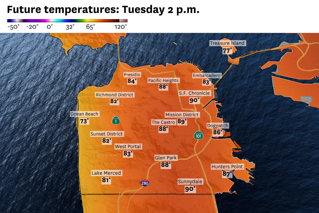
San Francisco: A warm warning will be a sign of the heat to come. Temperatures will push into the upper 80s to low 90s in the Mission District, downtown, North Beach and Potrero Hill. Highs will be in the low to mid-80s in the inner Richmond and Sunset districts. A weak, shallow marine layer should keep the perimeter of the city slightly cooler, in the upper 70s to low 80s. It’ll be warm overnight, with lows in the 60s, except in Golden Gate Heights, Twin Peaks, Diamond Heights and Mount Davidson, where temperatures will be in the low to mid-70s.
North Bay: The first 90-degree day of the year is forecast in most of Wine Country, though Petaluma, Napa and Vallejo may end up just shy of that mark. Regardless, temperatures will be 20 to 30 degrees above normal. The sea breeze won’t do the coast many favors, as highs are still forecast to reach the 80s there. Point Reyes may provide the best escape from the heat. Overnight lows will be in the mid-50s to low 60s in the valleys and mid-60s to mid-70s in the hills.
East Bay: Summerlike heat will grip the region, though the Caldecott Tunnel won’t prove to be the dividing line between fog and sun like it is in July. Bayshore cities will warm up nearly equally, with highs in the mid-80s to low 90s nearly everywhere. Alameda and Point Richmond may be spared by a shallow marine layer keeping temperatures in the upper 70s to low 80s. Overnight lows will be warm, in the low to mid-60s, except above 500 feet in the hills where it’ll remain in the upper 60s to mid-70s.
Pacific Coast and Peninsula: A 90-degree day is likely from South San Francisco to Redwood City. A shallow layer of cooler air may keep Foster City and other places northwest of Highway 101 in the 80s. Pacific beaches should be slightly cooler, in the 70s, though there won’t be much of a breeze and areas less than a mile inland will probably be in the 80s, including Daly City. It’ll be slow to cool overnight, with temperatures near 70 degrees at midnight and only dropping to the low to mid-60s by sunrise.
South Bay and Santa Cruz: There won’t be much escape from record-shattering March heat as even Santa Cruz is forecast to reach the mid-80s to low 90s. The Santa Cruz Mountains, San Jose foothills and Highway 85 corridor may reach the mid-90s. San Jose expected to surpass 90 degrees, which would be the city’s first time doing so on record in March. A weak afternoon and evening breeze will hardly cool things down as temperatures remain in the 70s through the evening. Lows will be in the 60s in the valleys and 70s in the mountains.