
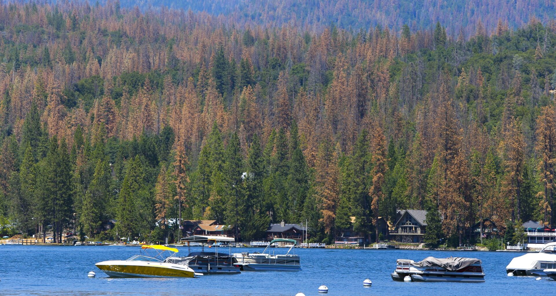
Aerial surveys by the U.S. Forest Service helped track an unprecedented tree die-off in the southern Sierra Nevada, as seen at Bass Lake, during last decade’s 5-year drought. The program’s flights were grounded last year because of funding cuts.
Michael Macor/The Chronicle
As California has endured increasingly severe droughts, a long-running federal research program has used planes to survey, and help explain, the growing toll on the landscape: how many trees have died, what areas are being hit hardest and where wildfire risk is greatest.
The state Aerial Detection Survey, run by the U.S. Forest Service, however, has become a casualty of the Trump administration, which has sought to aggressively slash spending, sometimes running afoul of federal courts, which have deemed many of its cuts illegal.
The research flights, which for decades crisscrossed California’s forests to assess their health, ground to a halt last year because of funding and staffing reductions, federal officials say. The program’s recently released annual report shows that less than a quarter of the area typically flown was covered in 2025, leaving researchers, land managers and fire agencies with an incomplete picture of forest conditions — and questions about when and if the surveys will return.
Article continues below this ad
Some are criticizing the rollback of the federal program, particularly its timing, as it comes as the warming climate is intensifying problems, and creating new ones, across the state’s wildlands.
“Our ability to detect emerging forest issues and address those challenges is going to be really impacted,” said Michael Jones, a forestry adviser at the University of California Cooperative Extension program, who uses the survey data to inform his work consulting on bugs, disease and other forest management concerns. “We have no other program that can fill this need.”
San Francisco Chronicle Logo
Make us a Preferred Source to get more of our news when you search.
Add Preferred Source
The U.S. Department of Agriculture, which oversees the Forest Service, did not detail the reasons for cutting the surveys. In response to a Chronicle inquiry about the funding and staff reductions, the agency provided a general statement about ensuring cost efficiency and preserving essential programs.
“In an effort to strengthen USDA’s services to the American people, the Forest Service is prioritizing critical work,” the statement read. “USDA fully supports the president’s directive to improve government, eliminate inefficiencies and strengthen USDA’s many services to the American people.”
Article continues below this ad
The Aerial Detection Survey has been around in some form in California since the 1970s.
The flights, which run at low altitudes so surveyors can see the ground below and make observations, were initially done over federal lands. But interest in the program’s dead tree counts and analysis of what’s driving disturbances on the landscape prompted the surveys to expand to other public and private forests.
Forests cover about one-third of California’s total land area.
The aerial survey program is credited with helping detect the spread of sudden oak death, a debilitating plant disease that wiped out more than a million oak and tanoak trees in California after its discovery in Marin County in 1994.
The program has also helped track the devastation of recent droughts. Since 2015, the Forest Service surveys estimate that more than 200 million trees, namely ponderosa and sugar pines as well as fir and cedar, have died statewide in an unprecedented die-off due in part to aridification amplified by climate change. The forests, in turn, have become more susceptible to burning.
Article continues below this ad
The state’s Cal Fire has used the federal survey data to help with its efforts to safely steward forests and fight wildfires.
“Understanding where dead or dying trees are on the landscape also provide information on potential wildfire intensity or severity, potential safety concerns to property or personnel, and what other ecosystem changes may be happening due to the loss of overstory or vegetation,” John Melvin, assistant deputy director of resource protection and improvement at Cal Fire, wrote in an email. “It can also help inform what mitigations might be necessary for such changes.”
The cuts to the survey program follow frequent commentary from the Trump administration, often directly from the president, about how California is mismanaging its forestlands. Federal officials, despite overseeing most of the state’s forests, have blamed the state for not doing more to make its wildlands resilient to fire.
The aerial surveys have sometimes been criticized for their large margin of error and for overestimating tree mortality. Since the program began last century, other methods of evaluating forest health have emerged, including the use of LiDAR and satellite imagery. The newer technology, though, also has disadvantages, among them the high cost.
Before the cuts last year, the aerial survey program in California operated on a budget of less than half a million dollars, with two full-time Forest Service staff, other part-time staff and contracted pilots and planes.
Article continues below this ad
One Forest Service official said more funding for the program is expected this year but it was yet to come.
Melvin, with Cal Fire, said state employees with his agency’s forest entomology and pathology program are planning to work with Forest Service staff to try to ensure that the federal flights resume.
Jones, with UC California Cooperative Extension, worries about a bigger problem: that cuts to the Aerial Detection Survey are part of a broader loss of scientific work at the federal government.
“There’s a whole conversation to be had around how this administration is cutting research,” Jones said. “It’s really causing a lot of doubt and concern about how we can conduct research on the scale we need to.”
Article continues below this ad