
It will feel like summer on the first day of spring in the Bay Area.
Baron/Lynx
Spring arrives at 7:46 a.m. on Friday. Our reward?
Perhaps the hottest day of a record-breaking heat wave. It’s a grand finale of sorts, with temperatures this weekend expected to drop as much as 15 degrees from the peak.
What a week it’s been. Since Monday, the region has broken or tied more than 30 daily high temperature records. Salinas broke its all-time March record Tuesday, then broke it again Wednesday. Redwood City has broken its daily record for four days running. In Napa, a mark that had stood since 1914 fell Wednesday.
Article continues below this ad
But on Thursday, the Bay Area offered up one of its classic microclimate curveballs. A shallow marine layer, maybe a few hundred feet thick, kept San Francisco and selected bayside locations cooler than forecast into the afternoon. Once it finally dissipated, temperatures were off to the races. Once it finally dissipated, temperatures were off to the races. San Francisco reached 86 degrees, breaking its daily record set in 2010.
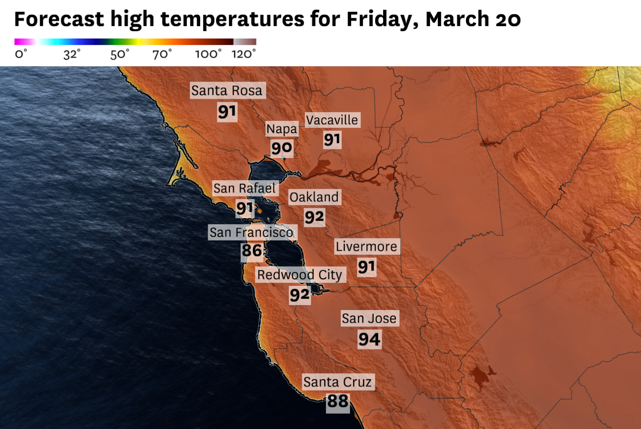
Friday looks different. Early morning offshore winds should dry out the atmosphere right as the sun rises and the season flips from winter to spring. Drier air, offshore flow and a warm upper-level air mass are a familiar recipe for a very warm day in the Bay Area.
San Francisco Chronicle Logo
Make us a Preferred Source to get more of our news when you search.
Add Preferred Source
Inland valleys will lead the way, with East Bay locations like Walnut Creek and Concord forecast to jump into the mid-90s. North Bay valleys won’t be far behind and even San Francisco, which got faked out Thursday, is forecast to reach 86, tying its monthly temperature record.
Article continues below this ad
Then comes the reset. The sprawling area of high pressure that baked the region all week begins shifting east Friday night, opening the door for an upstream cold front to push through Saturday. The marine layer, which made a cameo Thursday before retreating, will start rebuilding Friday night and return in force.
Temperatures on Sunday will feel much more refreshing and will be as much as 15 degree cooler than Friday.
Baron/Lynx
The front’s passage Saturday puts a firm end to the heat wave, knocking temperatures back 10 to 15 degrees from the peak. Sunday adds another 5-degree drop as the cool air settles in.
But here’s the catch. Even after the reset, temperatures this weekend will still run well above normal for late March. This week raised the bar that high.
Weekend breakdown
San Francisco: Friday is the main event. Highs climb into the upper 80s, and after Thursday’s marine layer interference, the city should come close to the monthly temperature record again. deliver this time. Offshore flow in the morning dries things out early, and with full sun, readings could flirt with the monthly record. The reset arrives Saturday, with clouds rolling in by morning and highs backing off to the mid 60s to upper 70s, as onshore winds pick up through the afternoon. Sunday settles into the lower 60s to mid 70s.
Article continues below this ad
North Bay: The valleys have been the heat engine all week and Friday is no different, with highs surging into the lower 80s to mid 90s depending on how far from the coast you are. Santa Rosa and Napa will be at the top end of that range. A weak cold front clips the region Saturday, dragging highs down into the 70s to 80s under partly cloudy skies. Sunday stays comfortable in the lower 70s to mid 80s.
East Bay: The inland valleys have been among the hottest spots in the region all week, and Friday closes out with highs in the upper 80s to lower 90s. Concord, Livermore and Walnut Creek will be at the top of that range. Clouds push in Saturday morning ahead of the front and highs ease back into the 70s to lower 80s with a westerly breeze picking up through the day. Sunday is a bit brighter and slightly cooler, with temperatures ranging through the 60s and 70s depending on how close you are to the bay.
Pacific Coast: An offshore breeze and no marine layer should allow temperatures to peak near 80 degrees on Friday. Cloudier and cooler on Saturday, highs will be pulled back into the 60s with a stiffening northwest wind in the afternoon. Sunday cools further with temperatures in the mid-60s.
Peninsula: Friday tops out in the mid 80s to lower 90s, with the inland side of the Peninsula staying hottest through the afternoon. Saturday morning clouds give way to partial sun by midday, but the sea breeze returns with the front and keeps highs in the 70s. Sunday comes out sunny with temperatures in the upper 60s to lower 70s.
Article continues below this ad
South Bay: The South Bay has run consistently hotter than the rest of the region all week, and Friday is the exclamation point, with highs peaking in the low to mid-90s. The cooldown arrives Saturday but with less force here than anywhere else, dropping to the lower 80s as the front’s reach weakens to the south. Sunday should land in the 70s, warm enough that it won’t feel much like a cooldown at all.