
Temperatures will slowly start to warm up again on Thursday.
Baron/Lynx
With just days left in the month, the Bay Area is nearing a historic milestone. This month is tracking as the driest March in more than a century of record-keeping.
There is one caveat. Accumulating rainfall looks increasingly likely on Tuesday, March 31st in a buzzer-beater that may mean the final numbers will fall short of such a record, though the overall trend will remain.
Through March 25th, just 0.06 inches of rain had fallen at the downtown San Francisco station, the second-driest March on record, trailing only 1923’s 0.03 inches of rain. Around the region, March totals range from 0.00 to 0.15 inches, well over 2 inches below normal.
Article continues below this ad
What happened in years like this one?
Looking at other historically dry Marches, 1972 stands out as the closest atmospheric match to 2026. Both years featured a fading La Niña, following a multi-year stretch of La Niña conditions. In 1972, that stretch ran from 1970 to 1972. In 2026, it follows an even longer run from 2020 to 2023.
Both years also shared a negative phase of the Pacific Decadal Oscillation (PDO), which occurs when ocean temperatures in the Central Pacific are warmer than ocean temperatures along the U.S. West Coast. This pattern tends to amplify drought conditions in the western U.S. when it runs negative.
San Francisco Chronicle Logo
Make us a Preferred Source to get more of our news when you search.
Add Preferred Source
In 1972, the dry pattern didn’t break for the rest of spring. Precipitation in April and May stayed well below normal. Downtown San Francisco recorded just 1.07 inches of rain in April, no rain in May, and just 0.11 inches in June. The April–June total of 1.18 inches of rain was below the average of 2.5 inches expected over those three months, based on 1990-2020 averages.
Article continues below this ad
California and much of the Southwest had a very dry April to June stretch in 1972. Precipitation totals for that 3-month period were 30 to 50 % below average in a continuation of a dry March that year.
PRISM/Oregon State
What does it mean for 2026?
Comparing analog weather years can be a useful exercise to help understand what may happen next, but history also shows that it does not guarantee the same outcome.
Of the top 10 driest Marches in the city’s history, five of those years went on to have well below normal precipitation through June, while the other five had above-average precipitation through June, with each of those years having particularly wet Aprils.
Several mitigating factors in 2026 will likely play a role in how the rest of the rainy season plays out. The oceans are running very warm. The atmospheric reactions to El Nino and La Nina have changed and the Sierra snowpack is running at historically low levels.
Article continues below this ad
Warm ocean waters can impact the position and strength of the jet stream, which can lead to either wetter or drier conditions. The lack of a snowpack will only increase soil moisture deficits, which can make heat waves more severe.
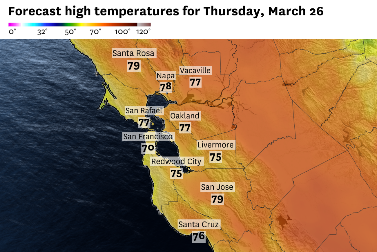
In the meantime, the Bay Area will stay dry on Thursday with a notable warming trend as temperatures rise back into the 80s across the interior, with a more muted warmup (into the 70s) closer to the water.
Thursday breakdown
San Francisco: Thursday’s conditions will look like Wednesday’s weather conditions in the city. Wispy high clouds will crisscross the sky and a north wind in the morning will keep temperatures cool at first, before the wind switches to the northwest by the afternoon. Temperatures will top out in the mid-60s at Ocean Beach and in the Presidio, while downtown and points east of Twin Peaks are closer to 70 degrees. More clouds filter in overnight, but it stays mild with lows in the mid-50s.
Article continues below this ad
North Bay: The valleys of the North Bay should warm up nicely again on Thursday. Along the highway 101 corridor, temperatures will rise into the low 80s in Petaluma and Santa Rosa. Highs will peak in the upper 70s in Novato, Benicia and Napa. Winds will be moderate from the northwest at 10 to 15 mph. Clouds build overnight and temperatures will cool off quickly after sunset, settling in the low to mid-40s.
East Bay: Thursday should start out nice and bright with lots of sunshine despite some high level clouds drifting by. The Richmond, Oakland to Hayward corridor will warm up into the mid- to upper 70s by the afternoon. A gusty north wind in the afternoon will keep temperatures slightly cooler, in the mid-70s, in the Tri-Valley and out towards Livermore. It will be mostly cloudy overnight, especially closer to the bay, with lows in the low to mid-50s.
Pacific Coast: Thursday is set to be a bit of a mixed bag along the Pacific Coast. The morning starts out with a mix of clouds and sunshine and a slight offshore wind could help places like Half Moon Bay warm up to 70 degrees. But places like Pacifica and Daly City will be more exposed to a northwest wind, keeping temperatures in the mid-60s. It will be mostly cloudy and mild overnight with temperatures in the low 50s.
Peninsula: The pattern that produced multiple daily temperature records at SFO is over. Thursday will be mostly sunny, with patches of fair weather clouds drifting through periodically. San Bruno and Millbrae will top out in the upper 60s, with highs in the low to mid-70s in San Mateo and Redwood City. Clouds build overnight but temperatures will be mild in the low 50s.
Article continues below this ad
South Bay: Along with the interior North Bay, the South Bay will have some of the warmer temperatures in the region on Thursday. Winds will be light and skies will be mostly sunny, allowing highs to warm into the upper 70s from Palo Alto to San Jose, with a few 80 degree readings scattered throughout. It will become mostly cloudy overnight with temperatures in the low 50s.